
Vat Phou or Wat Phu (temple-mountain) is a ruined Khmer temple complex in southern Laos. It is located at the base of mount Phu Kao, some 6 km from the Mekong river in Champasak province. There was a temple on the site as early as the 5th century, but the surviving structures date from the 11th to 13th centuries. The temple has a unique structure, in which the elements lead to a shrine where a linga was bathed in water from a mountain spring. The site later became a centre of Theravada Buddhist worship, which it remains today.
History
 Wat Phou was initially associated with the city of Shrestapura, which lay on the bank of the Mekong directly east of mount Lingaparvata (now called Phu Kao). By the latter part of the 5th century the city was already the capital of a kingdom which texts and inscriptions connect with both Chenla and Champa, and the first structure on the mountain was constructed around this time. The mountain gained spiritual importance from the linga-shaped protuberance on its summit; the mountain itself was therefore considered the home of Shiva, and the river as representing the ocean or the Ganges River. The temple was naturally dedicated to Shiva, while the water from the spring which emerges directly behind the temple was considered sacred.
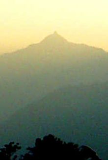 Wat Phou was a part of the Khmer empire, centred on Angkor to the southwest, at least as early as the reign of Yashovarman I in the early 10th century. Shrestapura was superseded by a new city in the Angkorian period, located directly south of the temple. In the later period, the original buildings were replaced, re-using some of the stone blocks; the temple now seen was built primarily during the Koh Ker and Baphuon periods of the 11th century. Minor changes were made during the following two centuries, before the temple, like most in the empire, was converted to Theravada Buddhist use. This continued after the area came under control of the Lao, and a festival is held on the site each February. Little restoration work has been done, other than the restoration of boundary posts along the path. Wat Phou was designated a World Heritage Site in 2001.
Like most Khmer temples, Wat Phou is orientated towards the east. although the axis actually faces eight degrees south of due east, being determined primarily by the orientation of the mountain and the river. Including the barays it stretches 1.4 km east from the source of the spring, at the base of a cliff 100 m up the hill. 6 km east of the temple, on the west bank of the Mekong, lay the city, while a road south from the temple itself led to other temples and ultimately to the city of Angkor.

Approached from the city (of which little remains), the first part of the temple reached is a series of barays. Only one now contains water, the 600 by 200 m middle baray which lies directly along the temples's axis; there were further reservoirs north and south of this, and a further pair on each side of the causeway between the middle baray and the palaces.
 The two palaces stand on a terrace on either side of the axis. They are known as the north and south palaces or, without any evidence, the men's and women's palaces (the term "palace" is also a mere convention — their purpose is unknown). Each consisted of a rectangular courtyard with a corridor and entrance on the side towards the axis, and false doors at the east and west ends. The courtyards of both buildings have laterite walls; the walls of the northern palace's corridor are also laterite, while those of the southern palace are sandstone. The northern building is now in better condition. The palaces are notable chiefly for their pediments and lintels, which are in the early Angkor Wat style.
 The next terrace has a small shrine to Nandin (Shiva's mount) to the south, in poor condition. The road connecting Wat Phou to Angkor ran south from this temple. Continuing west, successive staircases lead up further terraces; between them stands a dvarapala which has come to be worshipped as king Kammatha, mythical builder of the temple. On the narrow next terrace are the remains of six small shrines destroyed by treasure-hunters.
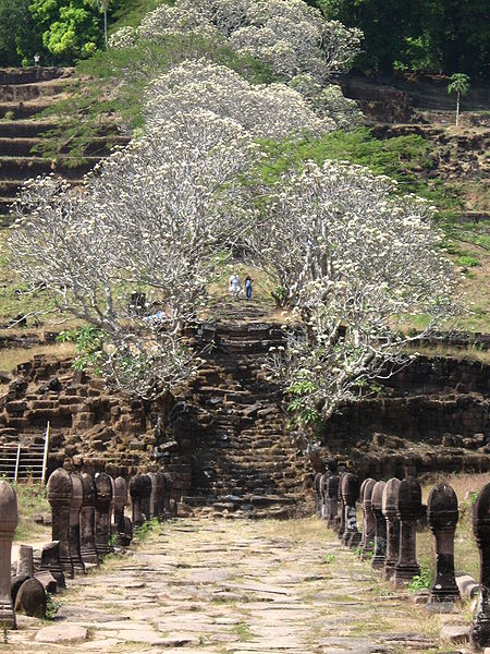
 The path culminates in seven sandstone tiers which rise to the upper terrace and central sanctuary. The sanctuary is in two parts. The front section, of sandstone, is now occupied by four Buddha images, while the brick rear part, which formerly contained the central linga, is empty. The entire roof is missing, although a makeshift covering has been added to the front. Water from the spring which emerges from the cliff about 60 m southwest of the sanctuary was channeled along stone aqueducts into the rear chamber, continuously bathing the linga. The sanctuary is later than the north and south palaces, belonging to the Baphuon period of the later 11th century. The east side has three doorways: from south to north, their pediments show Krishna defeating the naga Kaliya; Indra riding Airavata; and Vishnu riding Garuda. The east wall bears dvarapalas and devatas. Entrances to the south and north bear have inner and outer lintels, including one to the south of Krishna ripping Kamsa apart.
 Other features of the area are a library, in poor condition, south of the sanctuary, and a relief of the Hindu trinity to the northwest. There are other carvings further north: a Buddha's footprint on the cliff-face, and boulders shaped to resemble elephants and a crocodile. The crocodile stone has acquired some notoriety as being possibly the site of an annual human sacrifice described in a 6th century Chinese text; the identification is lent some plausibility by the similarity of the crocodile's dimensions to those of a human.
The Present

Global Heritage Fund, in association with the Lerici Institute (Italy) and the government of the Lao People's Democratic Republic, is providing emergency conservation of temple structures at this largest of archaeological sites in Laos. The stabilization and sustained conservation of Nandin Hall is the primary focus of these efforts, however the GHF-led team is working with local communities for training and development.
Within the framework of French – Lao cooperation project : "Priority solidarity funds Vat Phu Champassak. Historic and Cultural site arrangement and development ". The project has for objectives:
The institutional support for the creation of a body specialized management of the site.
The training of the scientific, technical and administrative staff.
The development of the site and its economic valuation.
The Indian Team from Archaeological survey of India, headed by Er. R. S. Jamwal arrived again in June 2009 at Vat Phou and conducted studies of foundations, drainage problems, super structural elements as well as did the documentation, recording, survey work etc. for the Northern Quadrangle of temple complex. The conservation and Restoration work of Northern Quadrangle is likely to be commenced from ensuing working season.

Champasak (or Champassak, Champasack) is a province in southwestern Laos, near the borders with Thailand and Cambodia. It is one of the three principalities that succeeded the Lao kingdom of Lan Xang. Population: 500,994 (2001 estimate). The river Mekong flows through the province. The capital of the province is Pakxe, but it takes its name from Champasak, the former capital of the Kingdom of Champasak. Champasak plays a central role in the history of Siam and Laos, with frequent battles taking place in and around Champasak. An English translation of Thao Suranaree, History of Important Thais, authored by Manit Plophinit and translated by Frank G Anderson, details the many references to Champasak.
 The small town of Champasak, location of the Khmer ruins of Wat Phu, is the seat of the Champasak District. Khone Phapheng Falls is in the province. Champasak is best known for a series of Khmer ruins, collectively named a UNESCO World Heritage Site as the Champasak Cultural Landscape.
 Neighboring are (from North clockwise) the provinces Salavan, Xekong and Attapu, as well as Cambodia (provinces Stung Treng and Preah Vihear) to the south and Thailand (Ubon Ratchathani Province) to the west.
Champasak can be reached from Thailand through the Chong Mek border crossing, at Vang Tao, from where the highway leads east towards the city of Pakxe. Crossing the border at Chong Mek is relatively straightforward, as there are large border posts on both sides of the border, as well as large outdoor markets. It is possible to obtain a Lao visa from this border post, and Thai baht and American dollars are widely accepted for purchases on the Lao side of the border.

Sources: http://en.wikipedia.org/wiki/Vat_Phou,
http://en.wikipedia.org/wiki/Champasak_Province
Images: http://commons.wikimedia.org/wiki/Category:Wat_Phou


0 comments:
Post a Comment