Phong Nha - Ke Bang (Vietnamese:Vườn quốc gia
Phong Nha-Kẻ Bàng) is a national
park and UNESCO World Heritage Site in the
Bố Trach and Minh
Hóa districts of central Quang
Binh Province, in north-central Vietnam,
about 500 km south of the nation's capital, Hanoi.
The park borders the Hin
Namno Nature Reserve in the province of
Khammouan, Laos by the
west, 42 km east of South
China Sea from its borderline point. Phong Nha-Ke
Bang National Park is situated in a limestone zone of 2,000 km2 in
Vietnamese territory and borders another limestone zone of 2,000 km2 of Hin
Namno in Laotian territory.
The core zone of this national park covers 857.54 km2 and a
buffer zone of 1,954 km2. The
park was created to protect one of the world's two largest karst regions
with 300 caves and grottoes and
also protects the ecosystem of limestone forest of the Annamite
Range region in north
central coast of Vietnam.
 The park is situated around
30 km west of South
China Sea and National
Road 1A, near Ho Chi Minh Highway and
28 km west of Hanoi-Saigon
Railway and is accessed by road or waterway by boat
through the estuary in South China Sea upwards. There is a small airport near
the park accessible by helicopter or small aircraft (Khe Gat Airbase), an
airbase used by North Vietnamese Air Force during Vietnam
War, notably in the Battle
of Đồng Hới.
The park is situated around
30 km west of South
China Sea and National
Road 1A, near Ho Chi Minh Highway and
28 km west of Hanoi-Saigon
Railway and is accessed by road or waterway by boat
through the estuary in South China Sea upwards. There is a small airport near
the park accessible by helicopter or small aircraft (Khe Gat Airbase), an
airbase used by North Vietnamese Air Force during Vietnam
War, notably in the Battle
of Đồng Hới.
Phong Nha-Ke Bang area is noted
for its cave and grotto systems as it is composed of 300 caves and grottos with
a total length of about 70 km, of which only 20 have been surveyed by
Vietnamese and British scientists; 17 of these are in located in the Phong Nha
area and three in the Ke Bang area. After April 2009, total length of caves and
grottoes are 126 km. Before
discovery of Son Doong Cave, Phong Nha held
several world cave records, as it has the longest underground river, as well as
the largest caverns and passageways.
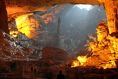
 The park derives its name from
Phong Nha cave, the most beautiful of all, containing many fascinating rock
formations, and Ke Bang forest. The plateau on which the park is situated is
probably one of the finest and most distinctive examples of a complex karst landform
in Southeast Asia.
The park derives its name from
Phong Nha cave, the most beautiful of all, containing many fascinating rock
formations, and Ke Bang forest. The plateau on which the park is situated is
probably one of the finest and most distinctive examples of a complex karst landform
in Southeast Asia.
This national park was listed
in UNESCO's World Heritage Sites in 2003 for
its geological values as defined in its criteria viii. In April 2009, the
world's largest cave Son
Doong Cave, was discovered by a team of British cave explorers of British
Caving Association.
 Since the recognition by UNESCO
in 2003, the government of Vietnam has continued to compile scientific
documentation to seek recognition of the park as a world natural heritage in
terms of biodiversity in addition to geographical values. According to World
Wildlife Foundation report in 2000, Phong Nha-Ke Bang National Park is one of
200 biodiversity centres of the world and one of the 60 significant sanctuaries
of Vietnam. It has a unique forest type in the world: green tropical forest. The
park also has 15 other types of forests.
Since the recognition by UNESCO
in 2003, the government of Vietnam has continued to compile scientific
documentation to seek recognition of the park as a world natural heritage in
terms of biodiversity in addition to geographical values. According to World
Wildlife Foundation report in 2000, Phong Nha-Ke Bang National Park is one of
200 biodiversity centres of the world and one of the 60 significant sanctuaries
of Vietnam. It has a unique forest type in the world: green tropical forest. The
park also has 15 other types of forests.
The park is situated around
30 km west of South
China Sea and National
Road 1A, near Ho Chi Minh Highway and
28 km west of Hanoi-Saigon
Railway and is accessed by road or waterway by boat
through the estuary in South China Sea upwards. There is a small airport near
the park accessible by helicopter or small aircraft (Khe Gat Airbase), an
airbase used by North Vietnamese Air Force during Vietnam
War, notably in the Battle
of Đồng Hới.
Climate
 Like Bac Trung Bo in general
and Quang Binh Province in particular, the climate in this national
park is tropical, hot, and humid. The annual mean temperature is 23 to 25 °C,
with a maximum of 41 °C in the summer and a minimum of 6 °C in the winter. The
hottest months in this region fall from June to August, with an average
temperature of 28 °C, and the coldest months from December to February with an
average temperature of 18 °C. Annual rainfall is 2,000 mm to
2,500 mm, and 88% of the rainfall is from July to December. With more than
160 rainy days per year, no month is without rain. Mean annual relative
humidity is 84%.
Like Bac Trung Bo in general
and Quang Binh Province in particular, the climate in this national
park is tropical, hot, and humid. The annual mean temperature is 23 to 25 °C,
with a maximum of 41 °C in the summer and a minimum of 6 °C in the winter. The
hottest months in this region fall from June to August, with an average
temperature of 28 °C, and the coldest months from December to February with an
average temperature of 18 °C. Annual rainfall is 2,000 mm to
2,500 mm, and 88% of the rainfall is from July to December. With more than
160 rainy days per year, no month is without rain. Mean annual relative
humidity is 84%.
Rivers and streams
 Besides the grotto and cave
systems, Phong Nha has the longest underground river. The Son and Chay are
the main rivers in this national park. Most of caves here have been shaped by
Son and Chay Rivers. The Son River flows into the mouth of the Phong Nha cave
and keeps on underground, where it is called as the Nam Aki River. It emerges
20 km to the south near Pu-Pha-Dam Mountain.
Besides the grotto and cave
systems, Phong Nha has the longest underground river. The Son and Chay are
the main rivers in this national park. Most of caves here have been shaped by
Son and Chay Rivers. The Son River flows into the mouth of the Phong Nha cave
and keeps on underground, where it is called as the Nam Aki River. It emerges
20 km to the south near Pu-Pha-Dam Mountain.
There are over ten spectacular
streams, springs and waterfalls in Phong Nha-Ke Bang area, namely: Gió
waterfall, Madame Loan waterfall, Mọc
stream erupting from a limestone mount range, and Trạ Ang stream.
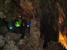
Cave and grottoes
 Phong Nha-Ke
Bang is home to the largest cave in the world and covers 300 different
grottoes and caves. Before Son Doong Cave was found, Phong Nha cave was regarded by British Caving
Association as the top cave in the world due to its 4 top records: the longest
underground river, the highest and longest cave, broadest and most beautiful
fine sand beaches inside the caves, the most spectacular stalagmites and
stalactites. In the
survey conducted in April 2009, the British cave explorers discovered 20 new
caves with total length of 56 km, including world's largest cave Son
Doong. According to
the assessment of UNESCO, the karst formation of Phong Nha-Ke Bang National
Park has evolved since the Palaeozoic (some 400 million years ago) and so is
the oldest major karst area in Asia and Phong Nha displays an impressive amount of evidence of
earth's history. It is a site of very great importance for increasing our
understanding of the geologic, geomorphic and geo-chronological history of the
region.
Phong Nha-Ke
Bang is home to the largest cave in the world and covers 300 different
grottoes and caves. Before Son Doong Cave was found, Phong Nha cave was regarded by British Caving
Association as the top cave in the world due to its 4 top records: the longest
underground river, the highest and longest cave, broadest and most beautiful
fine sand beaches inside the caves, the most spectacular stalagmites and
stalactites. In the
survey conducted in April 2009, the British cave explorers discovered 20 new
caves with total length of 56 km, including world's largest cave Son
Doong. According to
the assessment of UNESCO, the karst formation of Phong Nha-Ke Bang National
Park has evolved since the Palaeozoic (some 400 million years ago) and so is
the oldest major karst area in Asia and Phong Nha displays an impressive amount of evidence of
earth's history. It is a site of very great importance for increasing our
understanding of the geologic, geomorphic and geo-chronological history of the
region.
Tourist activities

The number of tourists has
increased dramatically since the park was listed in UNESCO's World Heritage
Sites. Quang Binh Province has invested into upgrading the Phong Nha-Ke
Bang visitor site to turn it into one of Vietnam's major tourist destinations.

Tourist activities in Phong Nha-Ke
Bang National Park are organized by local travel agencies and vary in form:
Tour for expedition of caves
and grottos in boats and with professional cave expedition means.
Ecotourism, discovering the
flora and fauna in this national park in the Ke Bang Forest.
Mountain climbing, trekking:
There are extreme sloping mountains here with a height of over 1,000 m, which
is a real challenge for adventurous climbers.

 Thanks to the tourism
development in this national park, about 1000 local residents have jobs in
tourism. The provincial Centre for Phong Nha-Ke Bang's Ecotourism and Culture
currently has 248 boats, creating jobs for 500 locals. Every boat has two
trained boatmen earning VND 70,000 per day. This income is relatively high for
peasants in this province. This centre also launched a programme in 2000 to
train former loggers to work as photographers taking pictures for tourists and
about 300 former loggers are now doing this.
Thanks to the tourism
development in this national park, about 1000 local residents have jobs in
tourism. The provincial Centre for Phong Nha-Ke Bang's Ecotourism and Culture
currently has 248 boats, creating jobs for 500 locals. Every boat has two
trained boatmen earning VND 70,000 per day. This income is relatively high for
peasants in this province. This centre also launched a programme in 2000 to
train former loggers to work as photographers taking pictures for tourists and
about 300 former loggers are now doing this.
In order to facilitate the
increasing flow of tourists to the site, the Dong Hoi Airport was constructed and
put into operation in May 2008 with air link with Hanoi’s Noi Bai International
Airport and
air link with Ho
Chi Minh City's Tan
Son Nhat International Airport beginning from 1 July 2009.
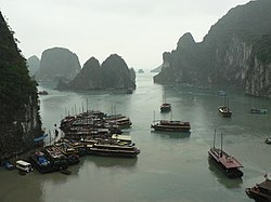
 Phong Nha-Ke Bang, together
with Ha
Long Bay and Fansipan of
Vietnam, is listed as a candidate for 7 new world natural wonders vote. As of
February 12, 2008 it ranked 10th in the voting list
Phong Nha-Ke Bang, together
with Ha
Long Bay and Fansipan of
Vietnam, is listed as a candidate for 7 new world natural wonders vote. As of
February 12, 2008 it ranked 10th in the voting list
In January 2009, the United States-based Los
Angeles Times listed
Phong Nha-Ke Bang National Park in its recommended world's 29
destinations to visit in 2009.
Source, Images:
http://en.wikipedia.org/wiki/Phong_Nha_Ke_Bang_National_Park


.jpg/200px-FishingVillage_HaLongBay_Vietnam_(pixinn.net).jpg)