Wednesday, June 22, 2011

Phuket Province - Thailand


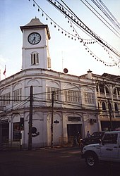
Phuket (Thai: ภูเก็ต), formerly known as Talang (Tha-Laang) and, in Western sources, Junk Ceylon (a corruption of the Malay Tanjung Salang, i.e. "Cape Salang"), is one of the southern provinces (changwat) of Thailand. Neighbouring provinces are (from north clockwise) Phang Nga and Krabi, but as Phuket is an island with no land boundaries.
Phuket, which is approximately the size of Singapore, is Thailand’s largest island. The island is connected to mainland Thailand by two bridges. It is situated off the west coast of Thailand in the Andaman Sea. Phuket formerly derived its wealth from tin and rubber, and enjoyed a rich and colorful history. The island was on one of the major trading routes between India and China, and was frequently mentioned in foreign ship logs of Portuguese, French, Dutch and English traders. The region now derives much of its income from tourism.
The name Phuket (of which the ph sound is an aspirated p) is apparently derived from the word bukit in Malay which means "hill", as this is what the island appears like from a distance. The region was formerly referred to as "Thalang" derived from the old Malay "Telong" which means "Cape". The northern district of the province, which was the location of the old capital, still uses this name.
History
In the 17th century, the Dutch, the English, and from the 1680s the French, competed with each other for trade with the island of Phuket (the island was named Junkseilon at that time), which was valued as a very rich source of tin. In September 1680, a ship from the French East India Company visited Phuket and left with a full cargo of tin. In 1681 or 1682, the Siamese king Narai, who was seeking to reduce Dutch and English influence, named Governor of Phuket the French medical missionary Brother René Charbonneau, a member of the Siam mission of the Société des Missions Etrangères. Charbonneau held the position of Governor until 1685.
In 1685, king Narai confirmed the French tin monopoly in Phuket to a French ambassador, the Chevalier de Chaumont. Chaumont's former maître d'hôtel Sieur de Billy was named governor of the island. The French were expelled from Siam in 1688 however, following the 1688 Siamese revolution. On April 10, 1689, the French general Desfarges led an expedition to re-capture the island of Phuket in an attempt to restore some sort of French control in Siam. The occupation of the island led nowhere, and Desfarges returned to Pondicherry in January 1690.
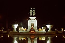
The Burmese attacked Phuket in 1785. Captain Francis Light, a British East India Company captain passing by the island, sent word to the local administration that he had observed Burmese forces preparing to attack. Than Phu Ying Chan, the wife of the recently deceased governor, and her sister Mook then assembled what forces they could. After a month-long siege, the Burmese were forced to retreat March 13, 1785. The two women became local heroines, receiving the honorary titles Thao Thep Kasattri and Thao Si Sunthon from King Rama I. During the reign of King Chulalongkorn (Rama V), Phuket became the administrative center of the tin-producing southern provinces. In 1933 Monthon Phuket (มณฑลภูเก็ต) was dissolved and Phuket became a province by itself. Old names of the island include Ko Thalang.
2004 Tsunami
On December 26, 2004, Phuket and other nearby areas on Thailand's western coast suffered extensive damage when they were struck by the Boxing Day tsunami caused by the 2004 Indian Ocean earthquake. The waves destroyed several highly populated areas in the region, killing as many as 5,300 people nationwide, and tens of thousands more throughout the wider Asian region. As many as 250 people were reported dead in Phuket including foreign tourists and as many as a thousand unreported deaths of illegal Burmese workers building new beach resorts in the Khao Lak area. Almost all the major beaches on the west coast, especially Kamala, Patong, Karon and Kata, sustained major damage, with some damage also being caused to resorts and villages on the island's southern beaches.
By February 2005 many damaged and most undamaged resorts were back in business, and throughout 2005 life slowly returned to normal for the people of Phuket. Following strenuous recovery programs, there is no remaining tsunami damage other than at the most remote beaches.
In the beginning of December 2006, Thailand launched the first of 22 U.S.-made tsunami-detection buoys to be positioned around the Indian Ocean as part of a regional warning system against giant waves caused by earthquakes under the sea. The satellite-linked deep-sea buoy will float 1,000 km (620 miles) offshore, roughly midway between Thailand and Sri Lanka.
Geography
Phuket is the biggest island in Thailand, located in the Andaman Sea of southern Thailand. The island is mostly mountainous with a mountain range in the west of the island from the north to the south. The mountains of Phuket form the southern end of the Phuket mountain range, which ranges for 440 kilometres (270 mi) from the Kra Isthmus. The highest elevation of the island is Mai Thao Sip Song (Twelve Canes), at 529 metres (1,736 ft) above sea level.
It is estimated that Phuket has a total area of approximately 570 square kilometres (220 sq mi) (including the province's other islands). Phuket is approximately 536 miles (863 km) south of Bangkok, and covers an area of approximately 543 square kilometres (210 sq mi) excluding small islets. It is estimated that if all its 39 other small islands are included, Phuket Province will cover an area of approximately 590 square kilometres (230 sq mi). The island total length, from north to south, is estimated at 30 miles (48 km) and 13 miles (21 km) wide.
Phuket's topology is exceptional with 70 percent of its area covered with mountains which stretch from north to south and the remaining 30 percent being plains located in the central and eastern parts of the island. The island does not have any major rivers except for a total of 9 brooks and creeks.
Forest, rubber and palm oil plantations cover 60% of the island. The western coast has several sandy beaches, while on the east coast beaches are more often muddy. Near the southernmost point is Laem Promthep (Brahma's Cape), which is a popular sunset viewing point. In the mountainous north of the island is the Khao Phra Thaeo Non-hunting Area, protecting more than 20 km² of rainforest. The three highest peaks of this reserve are the Khao Prathiu (384 metres (1,260 ft)), Khao Bang Pae 388 metres (1,273 ft) and Khao Phara 422 metres (1,385 ft). The Sirinat National Park on the northwestern coast was established in 1981 and protects an area of 90 square kilometres (35 sq mi) (68 kilometres (42 mi) marine area), including the Nai Yang beach where sea turtles lay their eggs.
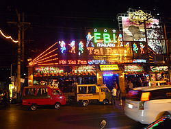
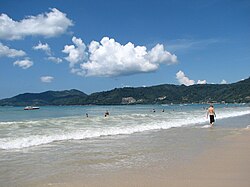
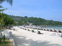
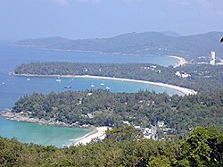
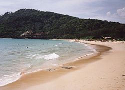
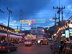
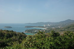
One of the most popular tourist areas on Phuket is Patong Beach on the central western coast, perhaps owing to the easy access to its wide and long beach. Most of Phuket's nightlife and its cheap shopping is located in Patong, and the area has become increasingly developed. Patong means "the forest filled with banana leaves" in Thai. Other popular beaches are located south of Patong. In a counterclockwise direction these include Karon Beach, Kata Beach, Kata Noi Beach, and around the southern tip of the island, Nai Harn Beach and Rawai. To the north of Patong are Kamala Beach, Surin Beach and Bang Tao Beach. These areas are generally much less developed than Patong, and sought out by individuals, families and other groups with a preference for more relaxed and less crowded environs than Patong. There are many islands to the southeast, including Bon Island, just a short boat trip away. There are several coral islands to the south of Phuket, the Similan Islands lie to the northwest, and Phi Phi Islands to the southeast. Islanders engage in a lively tourist trade, catering to snorkelers and scuba divers.
Attractions
  • Two Heroines Monument (อนุสาวรีย์วีรสตรี), a famous monument in Amphoe Thalang, is the memorial statue of the heroines Thao Thep Kasattri (Kunying Jan) and Thao Sri Sunthon (Mook), who rallied islanders in 1785 to repel Burmese invaders. As the island's governor had just died, organizing Phuket's defense against the Burmese invasion of 1785 was conducted by his widow, Thao Thep Kasattri. With her sister's help, they assembled what forces they had, then cleverly disguised local women as male soldiers, thus appearing to increase Phuket's military manpower. After a month's siege, the Burmese invaders became exhausted and retreated. King Rama I awarded Kunying Jan with the royal title of Thao Thep Kasattri.
  • Wat Chalong (วัดฉลองหรือวัดไชยธาราราม) is where stands the cast statue of Luang Poh Chaem, who helped the people of Phuket put down the Angyee, or Chinese Coolie Rebellion, in 1876 during the reign of Rama V. There are also statues of Luang Poh Chuang, and Luang Poh Chaem, abbots of the temple during later times.
  • Hat Patong (หาดป่าตอง) (Patong Beach) is Phuket's most developed beach and is 3 kilometres (1.9 mi)-long. It is located 15 km from Phuket town. Patong is mostly made up of hotels, restaurants, nightclubs and various tourist attractions. Daytime activities are primarily centered around the beach with many watersport activities available. Patong is equally well known for its nightlife, centered around Soi Bangla. Patong is also the cheap shopping option in Phuket selling items from clothes, fashion accessories to souvenirs. The northern end of Patong Bay is called Kalim and is a popular place for viewing the sunset and between April and September each year for surfing.
  • Hat Karon (หาดกะรน) is the second largest of Phuket's tourist beaches, approximately 20 kilometres (12 mi) from town. Large resort complexes line the road behind the shoreline, but the long, broad white sand beach itself has no development. Numerous restaurants and tourist stores are located across the street from the beach. The southern point has a fine coral reef stretching toward Kata and Bu Island. There is also its sister beach Karon Noi.
  • View Point (จุดชมวิว) This is located midpoint between Nai Han and Kata beaches. The scenic Kata Noi, Kata, and Karon beaches, and Ko Pu Island can be viewed from this point.
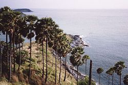
  • Laem Phromthep (แหลมพรหมเทพ) (Phromthep Cape) is a headland forming the extreme south end of Phuket. "Phrom" is Thai for the Hindu term "Brahma", signifying purity, and "Thep" is Thai for 'God'. Local villagers used to refer to the cape as "Laem Chao", or the God's Cape, and it was an easily recognizable landmark for the early seafarers traveling up the Malay Peninsula from the sub-continent.
  • Thalang National Museum (พิพิธภัณฑสถานแห่งชาติ ถลาง) is located near the Two Heroines Monument. In 1985, on the 200th anniversary of the Thalang War, the Thalang National Museum was established. The museum contains a permanent exhibition of life in old Phuket, ancient artefacts and remains discovered on the coast, and materials used during war with Burma (Myanmar).
  • Khao Phra Thaeo Wildlife Conservation Development and Extension Centre (สถานีพัฒนาและส่งเสริมการอนุรักษ์สัตว์ป่าเขาพระแทว) is a center for study of the environment. Its duty is to promote and distribute wildlife within Khao Phra Thaeo wildlife park. The park is full of virgin forest and also actively conserves a number of wild animals; they would otherwise be extinct in Phuket. Giant trees supported by huge buttresses are thick with creepers and climbers of every description.

Source: http://en.wikipedia.org/wiki/Phuket_Province
Images: http://commons.wikimedia.org/wiki/Category:Phuket

Tuesday, June 21, 2011

Patong & Karon Beach - Phuket

Patong Beach (Thai: หาดป่าตอง) refers to a beach on Phuket's west coast, and to the town adjoining it. It is the main tourist resort in Phuket. It also contains an important center of Phuket's nightlife and is the center of inexpensive shopping on the island. The beach became popular with Western tourists, especially Europeans, in the late 1980s. Numerous large hotels and chain hotels are located there.
Patong Beach is as equally famous for its nightlife as also the 3.5-kilometer beach that runs the entire length of Patong’s western side. Nightlife is centered on two main areas Bangla Road and 'Paradise Complex', with Bangla Road being predominantly straight and Paradise Complex being predominantly gay. Both roads are lined with many themed bars, discotheques, and go go bars. Prostitution in Thailand is illegal but tolerated as is the case with Patong Beach, especially on Bangla Road where there are many older Western men drinking with much younger Thai women and transvestites. Most discos in Patong charge a 100 baht admission fee but rather than being a cover charge, this is actually a drink minimum since you get a voucher and most clubs charge 100 baht for almost all drinks.
On December 26, 2004, Patong Beach along with many other areas along the western coast of Phuket and Thailand were struck by a tsunami caused by the 2004 Indian Ocean earthquake. The wave caused a great deal of destruction to the waterfront of the beach and immediately inland, and many people were killed there. Patong was one of the worst affected areas of Phuket, although the destruction was not nearly as bad as nearby in Khao Lak.
The island of Phuket has a tropical climate with a dry season from November to April and a rainy season from May to October. Average temperatures are consistent year-round. Average highs range from 29 °C (84 °F) to 33 °C (91 °F); average lows range from 23 °C (73 °F) to 26 °C (79 °F).
Karon Beach (Thai: หาดกะรน) refers to a beach, and the town adjoining it, on the western coast of Phuket, Thailand.
The beach is a popular destination for tourists. Generally quieter than neighbouring Patong Beach, it is especially popular among families and couples, and less popular with singles than Patong. It is also especially popular with Scandinavian tourists, with many businesses catering especially to them.
Karon Beach was heavily damaged by the tsunamis following the 2004 Indian Ocean earthquake, especially in its southern regions, but has since largely recovered and by 2008 showed little evidence of tsunami damage.

 
Sources: http://en.wikipedia.org/wiki/Patong_Beach, Karon_Beach
Images: http://commons.wikimedia.org/wiki/Category: Patong_Beach

Rawai & Nai Harn Beach - Phuket

Rawai Beach
The major attraction in Rawai must be Phromthep Cape which is famous for its romantic and spectacular sunsets. Though Rawai Beach itself is not an ideal place to swim, it has a charming and natural feel to it.
It has recently undergone a lot of renovations and now has a new pier and promenade and is worth spending some time there, especially with all its inexpensive seafood restaurants. For swimming, try nearby beaches such as Laem Ka, Ya Nui as well as Nai Harn Beach. 
Nai Harn Beach
Sometimes the charm of Nai Harn Beach is overlooked, with other west coast beaches getting a lot more attention. But ask the many frequent visitors to Nai Harn and they’ll tell you that they love the beach for its peaceful and unspoiled character. It’s also in a handy location, not far for all the action and fun nightlife spots (Patong is just 20 minutes away for example).
Beside the white sandy beach itself, there are a few interesting attractions in the area such as Nai Harn Lake, Nai Harn Monastery and a few nearby viewpoints such as Phromthep Cape and Kata Viewpoint.

Source: http://www.phuket.com/island/
Images: http://commons.wikimedia.org/wiki/Category:Phuket

Phromthep Cape - Phuket

Phromthep Cape or Laem Phromthep (แหลมพรหมเทพ) is probably the island's most photographed and perhaps best-known location. Every evening, large tour buses, scooters and cars sweep through Rawai and up the island's southernmost hill to the viewpoint. On the top of the hill stands a busy car park where vehicles disgorge crowds of people that have come from every corner of the world.
Cameras flash, fingers point and lovers cuddle as Phuket's most fabulous free show is re-enacted nightly – the sunset. Promthep also has a lighthouse that commands spectacular views over the east and southeast of the island and its environs.
It is air conditioned inside and if you go up to the outdoors viewing balcony you can see the distinctive shapes of the Phi Phi Islands, Koh Racha Yai and Koh Racha Noi on a clear day and of course a whole raft of nearer islands such as nearby Koh Kiaow with its Buddhist monastery.
The view from the cape is like a huge eternity pool from which you can mentally project the far-flung shores of Sri Lanka and the Indian Subcontinent and when night falls here you can peek down to the twinkling lights of Nai Harn Beach and Le Royal Phuket Yacht Club. Some people make the rather demanding trek down to the end of the cape but most stay up in the viewing part for sunset. By the car park there is a handicraft shop and a series of stalls that sell shells, batik, snacks, sarongs, shawls, toys and beachwear.
Elephant Shrine at Promthep Cape: Up the steps from the car park is a shrine to Brahma that is surrounded by thousands of wooden elephants of every size. It's all meticulously taken care of and the arrangement is photogenic, colourful and impressive. 

Source: http://www.phuket.com/island/phuket-viewpoints.htm
Images: http://commons.wikimedia.org/wiki/Category:Phuket

Wat Chalong - Phuket

In Phuket, there are 29 Buddhist temples spread around the island. In fact, this small island is also home to many other religions. There are Hindu and Sikh temples, Christian churches, mosques and Chinese shrines. Outside the wats there are also many more Buddhist shrines.
The most important of the 29 buddhist temples of Phuket is Wat Chalong (Thai: วัดฉลอง or วัดไชยธาราราม), located in the tambon Chalong, Mueang Phuket district. It is dedicated to two highly venerable monks, Luang Poh Chaem (หลวงพ่อแช่ม) and Luang Poh Chuang (หลวงพ่อช่วง), who with their knowledge of herbal medicine helped the injured of a tin miners rebellion in 1876.
Wat Chalong is about 8 km south of Phuket City. Travel along Chao Fah Nok Road (Chao Fa West Rd) from the Central Festival mall, and you will see the temple on the left side of the road. If you are coming from Chalong Circle, take the same road heading towards town, and you will see the temple on your right.
Wat Chalong has been extending a warm welcome to visitors for over a century. Locals come to pray and Westerners come to learn something about Buddhism. The temple is open from seven in the morning to five in the afternoon.
Poh Than Jao Wat is one of the more important Buddhist statues in Wat Chalong. It is located in the westerly old hall of the temple, with two statues of an elderly gentleman called Ta Khee-lek (grandpa Khee-lek), a famous local who won many lotteries after consulting the Poh Than Jao Wat statue. Another statue in this hall is called Nonsi.
One of the temple's halls features a gilt-covered statue of Luang Poh Chaem and this busy hall also contains statues of Luang Poh Chuang and Luang Poh Gleum, all ex-abbots of the temple. 
The Grand Pagoda dominating the temple contains a splinter of Lord Buddha's bone and is officially named Phramahathatchedi-Jomthaibarameepragat. The pagoda is decorated with wall paintings depicting the Buddha's life story and also features various Buddha images. Take your time in the pagoda; it is a breezy, cool location and one which is very popular with visitors to the temple.
There is also an air-conditioned 'exhibition home' of Luang Poh Chaem which features lifelike human-sized wax models of Luang Poh Chaem, Luang Poh Chuang, Luang Poh Gleum, and Luang Pu Thuad along with antique Thai furniture, and Benjarong (เบญจรงค์, Thai porcelain designed in five colours), while the famous 'magic' walking-stick of Luang Poh Chaem is kept at the current Abbot's dwelling.      
Do's and Don'ts
Wats in general are sacred places for local people, so it is wise for the visitor to watch and emulate the way Thais behave inside temples. For example, you will see that people are careful not to stand over, or otherwise position themselves higher than any Buddha images except when pasting gold leaf to them - which in any case happens only in some wats, not in most.
Even through Thailand can sometimes be very warm, it is inappropriate to go into a wat - a place of worship - wearing clothes that reveal one's shoulders, chest, belly or legs.
You will be asked to take your shoes off when entering some of the buildings, including the sermon hall and the chedi. It's best not to wear your most expensive shoes when visiting wats in case someone else mistaken walks away with them - literally! If that happens, and they are not your favorite shoes, then you won't be too upset.

Sources, Images: http://en.wikipedia.org/wiki/Wat_Chalong,
http://www.phuket.com/island/wat-chalong.htm

Monday, June 13, 2011

Hikone Castle - Shiga

Hikone Castle (Hikone-jō) is the most famous historical site in Hikone, Shiga Prefecture, Japan. This Edo period castle traces its origin to 1603 when Ii Naokatsu, son of the former daimyo Ii Naomasa, ordered its construction. The keep was originally built in 1575, as part of Ōtsu Castle, and was moved to Hikone by the Ii clan. Other parts of the castle were moved from Nagahama Castle. Hikone Castle was completed in 1622. Naokatsu's lands had been taken from him in the interval by the Tokugawa shogunate, and when his brother Naotake assumed control of the area around Ōmi Province, he was able to complete the castle by collecting stones from the former Sawayama Castle.
When the Meiji era began in 1868, many castles were scheduled to be dismantled, and only a request from the emperor himself, touring the area, kept Hikone Castle intact. Today it remains one of the oldest original-construction castles in Japan. Hikone Castle was designated a National Treasure by the Ministry of Education, Science, Sports and Culture in 1952.


Source, Images: http://en.wikipedia.org/wiki/Hikone_Castle

Himeji Castle - Hyogo

Himeji Castle (Himeji-jō) is a hilltop Japanese castle complex located in Himeji in Hyōgo Prefecture. The castle is regarded as the finest surviving example of prototypical Japanese castle architecture, comprising a network of 83 buildings with advanced defensive systems from the feudal period. The castle is frequently known as Hakurojō ("White Egret Castle") or Shirasagijō ("White Heron Castle") because of its brilliant white exterior and supposed resemblance to a bird taking flight.
Himeji Castle dates to 1333, when Akamatsu Norimura built a fort on top of Himeyama hill. The fort was dismantled and rebuilt as Himeyama Castle in 1346, and then remodeled into Himeji Castle two centuries later. Himeji Castle was then significantly remodeled in 1581 by Toyotomi Hideyoshi, who added a three-story castle keep. In 1600, Tokugawa Ieyasu awarded the castle to Ikeda Terumasa for his help in the Battle of Sekigahara, and Ikeda completely rebuilt the castle from 1601 to 1609, expanding it into a large castle complex. Several buildings were later added to the castle complex by Honda Tadamasa from 1617 to 1618. For over 400 years, Himeji Castle has remained intact, even throughout the extensive bombing of Himeji in World War II, and natural disasters such as the 1995 Great Hanshin earthquake.
Himeji Castle is the largest and most visited castle in Japan, and it was registered in 1993 as one of the first UNESCO World Heritage Sites in the country. The area within the middle moat of the castle complex is a designated Special Historic Site and five structures of the castle are also designated National Treasures. Along with Matsumoto Castle and Kumamoto Castle, Himeji Castle is considered one of Japan's three premier castles. In order to preserve the castle buildings, it is currently undergoing restoration work that is expected to continue for several years.
History
Himeji Castle's construction dates to 1333, when a fort was constructed on Himeyama hill by Akamatsu Norimura, the ruler of the ancient Harima Province. In 1346, his son Sadonori demolished this fort and built Himeyama Castle in its place. In 1545, the Kuroda clan was stationed here by order of the Kodera clan, and feudal ruler Kuroda Shigetaka remodeled the castle into Himeji Castle, completing the work in 1561. In 1580, Kuroda Yoshitaka presented the castle to Toyotomi Hideyoshi, and in 1581 Hideyoshi significantly remodeled the castle, building a three-story castle keep with an area of about 55 m2 (592 ft2).
Following the Battle of Sekigahara in 1600, Tokugawa Ieyasu granted Himeji Castle to his son-in-law, Ikeda Terumasa, as a reward for his help in battle. Ikeda demolished the three-story keep that had been created by Hideyoshi, and completely rebuilt and expanded the castle from 1601 to 1609, adding three moats and transforming it into the castle complex that is seen today. The expenditure of labor involved in this expansion is believed to have totaled 25 million man-days. Ikeda died in 1613, passing the castle to his son, who also died three years later. In 1617, Honda Tadamasa and his family inherited the castle, and Honda added several buildings to the castle complex, including a special tower for his daughter-in-law, Princess Sen (Senhime).
In the Meiji Period (1868 to 1912), many Japanese castles were destroyed. Himeji Castle was abandoned in 1871 and some of the castle corridors and gates were destroyed to make room for Japanese army barracks. The entirety of the castle complex was slated to be demolished by government policy, but it was spared by the efforts of Nakamura Shigeto, an Army colonel. A stone monument honoring Nakamura was placed in the castle complex within the first gate, the Diamond Gate (Hishimon). Although Himeji Castle was spared, Japanese castles had become obsolete and their preservation was costly.
When the han feudal system was abolished in 1871, Himeji Castle was put up for auction. The castle was purchased by a Himeji resident for 23 Japanese yen (about 200,000 yen or US$2,258 today). The buyer wanted to demolish the castle complex and develop the land, but the cost of destroying the castle was estimated to be too great, and it was again spared.
Himeji was heavily bombed in 1945, at the end of World War II, and although most of the surrounding area was burned to the ground, the castle survived intact. One firebomb was dropped on the top floor of the castle but miraculously failed to explode. In order to preserve the castle complex, substantial repair work was undertaken starting in 1956, with a labor expenditure of 250,000 man-days and a cost of 550 million yen. In January 1995, the city of Himeji was substantially damaged by the Great Hanshin earthquake, but Himeji Castle again survived virtually undamaged, demonstrating remarkable earthquake resistance. Even the bottle of sake placed on the altar at the top floor of the keep remained in place.
Historical recognition
Himeji Castle was registered on December 11, 1993 as one of the first UNESCO World Heritage Sites in Japan. Five structures of the castle are also designated National Treasures: the castle keep (tenshukaku), northwest small tower (,inui shōtenshu), west small tower (nishi shōtenshu), east small tower (,higashi kotenshu), and I, Ro, Ha, Ni-corridors (i, ro, ha, ni no watariyagura). The area within the middle moat of the castle complex is a designated Special Historic Site.
Along with Matsumoto Castle and Kumamoto Castle, Himeji Castle is considered one of Japan's three premier castles. It is the most visited castle in Japan, receiving over 820,000 visitors annually. Starting in April 2010, Himeji Castle underwent restoration work to preserve the castle buildings, and this work is expected to continue until 2014. Entry to the castle keep is closed throughout the renovation, but visitors can view the restoration process from observation platforms and they can continue to enter other areas of the castle complex.
Design details
Himeji Castle is the largest castle in Japan. It serves as an excellent example of prototypical Japanese castle architecture, containing many of the defensive and architectural features associated with Japanese castles. The curved walls of Himeji Castle are sometimes said to resemble giant fans (sensu), but the principle materials used in the structures are stone and wood. Feudal family crests (,mon) are installed throughout the architecture of the building, signifying the various lords that inhabited the castle throughout its history.
The Himeji Castle complex is located in the center of Himeji, Hyōgo on top of a hill called Himeyama, which is 45.6 m (150 ft) above sea level. The castle complex comprises a network of 83 buildings such as storehouses, gates, corridors, and turrets (yagura). Of these 83 buildings, 74 are designated as Important Cultural Assets: 11 corridors, 16 turrets, 15 gates, and 32 earthen walls. The highest walls in the castle complex have a height of 26 m (85 ft). Joining the castle complex is Koko-en Garden (Kōkoen), a Japanese garden created in 1992 to commemorate Himeji city's 100th anniversary.
From east to west, the Himeji Castle complex has a length of 950 to 1,600 m (3,117 to 5,249 ft), and from north to south, it has a length of 900 to 1,700 m (2,953 to 5,577 ft). The castle complex has a circumference of 4,200 m (2.53 mi). It covers an area of 233 hectares (2,330,000 m2 or 576 acres), making it roughly 50 times as large as the Tokyo Dome or 60 times as large as Koshien Stadium.
The castle keep (tenshukaku) at the center of the complex is 46.4 m (152 ft) high, standing 92 m (302 ft) above sea level. Together with the keep, three smaller subsidiary towers (kotenshu) form a cluster of towers. Externally, the castle keep appears to have five floors, because the second and third floors from the top appear to be a single floor; however, the tower actually has six floors and a basement. The basement of the keep has an area of 385 m2 (4,144 ft2), and the interior of the keep contains special facilities that are not seen in other castles, including lavatories, a drain board, and a kitchen corridor.
The keep has two pillars, with one standing in the east and one standing in the west. The east pillar, which has a base diameter of 97 cm (38 in), was originally a single fir tree, but it has since been mostly replaced. The base of the west pillar is 85 by 95 cm (33 by 37 in), and it is made of Japanese cypress. During the Shōwa Restoration (1956–1964) a Japanese cypress tree with a length of 26.4 m (87 ft) was brought down from the Kiso Mountains and replaced the old pillar. The tree was broken in this process, so another tree was brought down from Mount Kasagata, and the two trees were joined on the third floor.
The first floor of the keep has an area of 554 m2 (5,963 ft2) and is often called the "thousand-mat room" because it has over 330 Tatami mats. The walls of the first floor have weapon racks (,bugukake) for holding matchlocks and spears, and at one point, the castle contained as many as 280 guns and 90 spears. The second floor of the keep has an area of roughly 550 m2 (5,920 ft2).
The third floor has an area of 440 m2 (4,736 ft2) and the fourth floor has an area of 240 m2 (2,583 ft2). Both the third and fourth floors have platforms situated at the north and south windows called "stone-throwing platforms" (,ishiuchidana), where defenders could observe or throw objects at attackers. They also have small enclosed rooms called "warrior hiding places" (,mushakakushi), where defenders could hide themselves and kill attackers by surprise as they entered the keep. The final floor, the sixth floor, has an area of only 115 m2 (1,237 ft2). The sixth floor windows now have iron bars in place, but in the feudal period the panoramic view from the windows was unobstructed.
Defenses
Himeji Castle contains advanced defensive systems from the feudal period. Loopholes (sama) in the shape of circles, triangles, and rectangles are located throughout Himeji Castle, intended to allow defenders armed with matchlocks or archers to fire on attackers without exposing themselves. Roughly 1,000 loopholes exist in the castle buildings remaining today. Angled chutes called "stone drop windows" (ishi-otoshi-mado) were also set at numerous points in the castle walls, enabling stones or boiling oil to be poured on the heads of attackers passing by underneath, and white plaster was used in the castle’s construction for its resistance to fire.
The castle complex included three moats, one of which—the outer moat—is now buried. Parts of the central moat and all of the inner moat survive. The moats have an average width of 20 m (66 ft), a maximum width of 34.5 m (113 ft), and a depth of about 2.7 m (8.9 ft). The Three Country Moat (sangoku-bori) is a 2,500 m2 (26,910 ft2) pond; one of the purposes of this moat was to store water for use in fire prevention.
The castle complex, particularly the Waist Quarter (koshikuruwa), contains numerous warehouses that were used to store rice, salt, and water in case of a siege. A building known as the Salt Turret (shioyagura) was used specifically to store salt, and it is estimated that it contained as many as 3,000 bags of salt when the castle complex was in use. The castle complex also contained 33 wells within the inner moat, 13 of which remain; the deepest of these has a depth of 30 m (98 ft).
One of the castle's most important defensive elements is the confusing maze of paths leading to the castle keep. The gates, baileys, and outer walls of the complex are organized so as to confuse an approaching force, causing it to travel in a spiral pattern around the complex on its way to the keep. The castle complex originally contained 84 gates, 15 of which were named according to the Japanese syllabary (I, Ro, Ha, Ni, Ho, He, To, etc). At present, 21 gates from the castle complex remain intact, 13 of which are named according to the Japanese syllabary.
In many cases, the castle walkways even turn back on themselves, greatly inhibiting navigation. For example, the straight distance from the Diamond Gate (hishimon) to the castle keep (tenshukaku) is only 130 m (427 ft), but the path itself is a much longer 325 m (1,066 ft). The passages are also steep and narrow, further inhibiting entry. This system allowed the intruders to be watched and fired upon from the keep during their lengthy approach, but Himeji Castle was never attacked in this manner so the system remains untested. However, even today with the route clearly marked, many visitors have trouble navigating the castle complex.
Cultural impact
Himeji Castle is frequently known as Hakurojō ("White Egret Castle") or Shirasagijō ("White Heron Castle") because of its brilliant white exterior and supposed resemblance to a bird taking flight. The castle has been featured extensively in foreign and Japanese films, including Akira Kurosawa's Kagemusha (1980) and Ran (1985).
Folklore
Himeji Castle is associated with a number of feudal Japanese folklore stories. The ghost story of The Dish Mansion at Banchō (Banchō Sarayashiki) was centered around Okiku's Well, one of the wells at Himeji Castle that remains to this day. According to the legend, Okiku was falsely accused of losing dishes that were valuable family treasures, and then killed and thrown into the well. Her ghost remained to haunt the well at night, counting dishes in a despondent tone.
The legend of the "Old Widow's Stone" (Ubagaishi) is another folklore story associated with the castle. According to the legend, Toyotomi Hideyoshi ran out of stones when building the original three-story castle keep, and an old woman heard about his trouble. She gave him her hand millstone even though she needed it for her trade. It was said that people who heard the story were inspired and also offered stones to Hideyoshi, speeding up construction of the castle. To this day, the supposed stone can be seen covered with a wire net in the middle of one of the stone walls in the castle complex.
A folklore story is also associated with Genbei Sakurai, who was Ikeda Terumasa's master carpenter in the construction of the castle keep. According to the legend, Sakurai was dissatisfied with his construction, feeling that the keep leaned a little to the southeast. Eventually, he became distraught and climbed to the top of the keep, where he jumped to his death with a chisel in his mouth.


Source: http://en.wikipedia.org/wiki/Himeji_Castle
Images: http://commons.wikimedia.org/wiki/Category: Himeji_Castle

Followers