Showing posts with label Laos. Show all posts

Tuesday, January 11, 2011

Vientiane - Laos

Vientiane (Lao: Wiang-jun; Thai: เวียงจันทน์ Wiang-chan; literally "City of Sandalwood") is the capital and largest city of Laos, situated in the Mekong river. Vientiane became the capital in 1563 due to fears of a Burmese invasion. During French rule, Vientiane was the administrative capital and due to economic growth in recent times, it has become the economic centre of Laos.
The estimated population of the city is 726,000 (2007) while the number of people living in the Vientiane metropolitan area (the entire Vientiane Prefecture and parts of Vientiane Province) is believed to be over 730,000. The city hosted for the first time the 25th Southeast Asian Games in December 2009 celebrating the 50 years of SEA Games.
Sri Sattanak, or Sisattanak  is a former name of Vientiane. It is often confused with Sri Sattanakanahut, the Pali name of Lan Xang, the Kingdom of the Million Elephants. Sisattanak now is the name of one of the five districts of the city Vientiane.
The name of the city is derived from Pali, the liturgical language of Theravada Buddhism. Its original meaning is "royal sandalwood grove" or "city of sandalwood", this tree being highly valued in classical India for its fragrance. In modern Lao, the meaning of Vientiane is ambiguous, and is often mistakenly believed to mean "city of the moon", because the words for 'moon (Chandra in Sanskrit)' and 'sandalwood (chandana in Sanskrit)' are written and pronounced identically as 'jan'. However, the name in Thai, เวียงจันทน์, retains the etymologically correct spelling, and clearly indicates "city of sandalwood" as the meaning. The romanized spelling "Vientiane" is of French origin, and reflects the difficulty the French had in pronouncing the hard "j" sound in the Lao word; a common English-based spelling is "Viangchan", or occasionally "Wiangchan".
History
The great Laotian epic, the Phra Lak Phra Lam, claims that Prince Thattaradtha founded the city when he left the legendary Lao kingdom of Muong Inthapatha Maha Nakhone because he was denied the throne in favor of his younger brother. Thattaradtha founded a city called Maha Thani Si Phan Phao on the western banks of the Mekong River; this city was told to have later become today's Udon Thani, Thailand. One day, a seven-headed Naga told Thattaradtha to start a new city on the eastern bank of the river opposite Maha Thani Si Phan Phao. The prince called this city Chanthabuly Si Sattanakhanahud; which was told to be the predecessor of modern Vientiane.
Contrary to the Phra Lak Phra Ram, most historians believe Vientiane was an early Khmer settlement centered around a Hindu temple, which the Pha That Luang would later replace. In the 11th and 12th centuries, the time when the Lao and Thai people are believed to have entered Southeast Asia from Southern China, the few remaining Khmers in the area were either killed, removed, or assimilated into the Lao civilization, which would soon overtake the area.
In 1354, when Fa Ngum founded the kingdom of Lan Xang, Vientiane became an important administrative city, even though it was not made the capital. King Setthathirath officially established it as the capital of Lan Xang in 1563, to avoid Burmese invasion. When Lan Xang fell apart in 1707, it became an independent Kingdom of Vientiane. In 1779, it was conquered by the Siamese general Phraya Chakri and made a vassal of Siam.
When King Anouvong raised an unsuccessful rebellion, it was obliterated by Siamese armies in 1827. The city was burned to the ground and was looted of nearly all Laotian artifacts including Buddha statues and people. Vientiane was in great disrepair when the French arrived, arrived to only find a depopulated region with even the great city of Vientiane disappearing into the forest. It eventually passed to French rule in 1893. It became the capital of the French protectorate of Laos in 1899. The French rebuilt the city and rebuilt or repaired Buddhist temples such as Pha That Luang, Haw Phra Kaew, and left many colonial buildings behind.
Vientiane was the host of the incident free 2009 Southeast Asian Games, with 18 disciplines being dropped from the previous games held in Thailand due to Laos' landlocked state and the lack of adequate facilities in Vientiane.
Vientiane is situated on a bend of the Mekong river, which forms the border with Thailand at this point. Vientiane features a tropical wet and dry climate (Koppen Aw) with a distinct monsoon season and a dry season. Vientiane’s dry season spans from November through March. April marks the onset of the monsoons which in Vientiane lasts about seven months. Vientiane tends to be hot and humid throughout the course of the year, though temperatures in the city tend to be somewhat cooler during the dry season than the wet season.
Sights
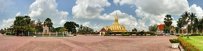
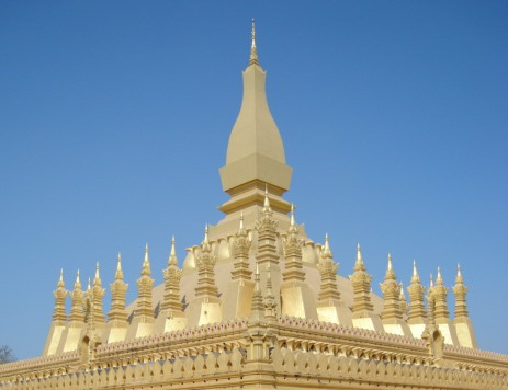
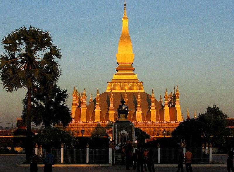
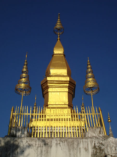
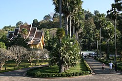
Although a small city still, the capital has many sites for tourist to see. The city contains many temples and Buddhist monument with Pha That Luang, a Buddhist stupa, one of the most famous in Laos. It is the most important national cultural monument and very popular amongst foreign tourist. The original was built in 1566 by King Setthathirath, and was restored in 1953. The golden stupa is 45 meters tall and is believed to contain a relic of the Lord Buddha.
Another site that is also popular amongst tourist is Wat Si Muang. The temple was built on the ruins of a Khmer Hindu shrine, the remains of which can be seen behind the ordination hall. It was built in 1563 and is believed to be guarded by the spirit of a local girl called “Si". Legend says that Nang Si, who was pregnant at the time, leapt to her death as a sacrifice, just as the pillar was being lowered into the hole. In front of the temple stands a statue of King Sisavang Vong.
The memorial monument, Patuxai, began construction in 1957 and completed in 1968, is perhaps the most prominent landmark in the city. While the arc de Triomphe in Paris inspired the architecture, the design incorporates typical Lao motifs including “Kinnari”, a mythical bird woman. Energetic visitors can climb to the top of the monument, which reveals an excellent panoramic view of the city.
Buddha Park was built in 1958 by Luang Pou Bounlua Soulilat and contains a collection of Buddhist and Hindu sculptures, scattered amongst gardens and trees. The park was built about 28 kilometers south of Vientiane at the edge of the Mekong River.
Vientiane is home to one of Laos' only bowling alleys (the other bowling alley being in Luang Prabang) and its only mosques. There are many upper-class hotels in Vientiane.
Other sites include:
  • Haw Phra Kaew, former temple, now museum and small shops
  • Lao National Museum
  • Talat Sao Morning Market
  • That Dam, large stupa
  • Wat Ong Teu Mahawihan, Buddhist monastery
  • Wat Si Saket, Buddhist wat
  • Wat Sok Pa Luang, Buddhist temple
Transportation
From Thailand: The First Thai-Lao Friendship Bridge, built in the 1990s, crosses the river 18 kilometers downstream of the city to Nong Khai in Thailand, and is the major crossing between the two countries. The bridge was built with provision for metre gauge rail services. Test trains began running and Thanaleng Railway Station on July 4, 2008, and the railway was formally inaugurated on March 5, 2009. Surveys are underway to continue to the line a further 12 km to Vientiane.
The official name of the bridge was changed in 2007 by the addition of "First", after the Second Friendship Bridge linking Mukdahan in Thailand with Savannakhet in Laos was opened early in 2007.
In October 2010, plans were announced for a 530km high-speed railway linking Vientiane to Xishuangbanna, in Yunnan province in China.
Within Laos: There are regular bus services connecting Vientiane Bus Station with the rest of the country.
To Thailand: Daily non stop direct bus services run between Vientiane and Nong Khai, Udon Thani and Khon Kaen.
By Air: Vientiane is served by the Wattay International Airport with international connections to other Asian countries. Lao Airlines has regular flights to several domestic destinations (several flights daily to Luang Prabang; a few flights weekly to other destinations).
Healthcare
The "Centre Medical de l’Ambassade de France" is available to the foreign community in Laos in April 2007. Also the Mahosot Hospital is an important hospital in treating and researching diseases and is in connection with the University of Oxford.

Source: http://en.wikipedia.org/wiki/Vientiane
Images: http://commons.wikimedia.org/wiki/Category:Vientiane

Pha That Luang - Vientiane

Pha That Luang ('Great Stupa') is a gold-covered large Buddhist stupa in the center of Vientiane, Laos. Since its initial establishment suggested to be in the 3rd century, the stupa has undergone several reconstructions until the 1930s due to foreign invasions to the area. It is generally regarded as the most important national monument in Laos and a national symbol.
History
Pha That Luang according to the Lao people was originally built as an Indic temple in the 3rd century. Buddhist missionaries from the Mauryan Empire are believed to have been sent by the Emperor Ashoka, including Bury Chan or Praya Chanthabury Pasithisak and five Arahata monks who brought a holy relic (believed to be the breast bone) of Lord Buddha to the stupa. It was rebuilt in the 13th century as a Khmer temple which fell into ruin.
In the mid-16th century, King Setthathirat relocated his capital from Luang Prabang to Vientiane and ordered construction of Pha That Luang in 1566. It was rebuilt about 4 km from the centre of Vientiane at the end of That Luang Road and named Pha That Luang. The bases had a length of 69 meters each and was 45 meters high, and was surrounded by 30 small Stupas.
In 1641, a Dutch envoy of the Dutch East India Company, Gerrit van Wuysoff, visited Vientiane and was received by King Sourigna Vongsa at the temple, where he was, reportedly, received in a magnificent ceremony. He wrote that he was particularly impressed by the "enormous pyramid and the top was covered with gold leaf weighing about a thousand pounds". However, the stupa was repeatedly plundered by the Burmese, Siamese and Chinese.
Pha That Luang was destroyed by the Thai invasion in 1828, which left it heavily damaged and left abandoned. It was not until 1900, when the French restored to its original design based on the detailed drawings from 1867 by the French architect and explorer Louis Delaporte. However the first attempt to restore it was unsuccessful and it had to be resigned and then reconstructed in the 1930s.
The architecture of the building includes many references to Lao culture and identity, and so has become a symbol of Lao nationalism. The stupa today consists of three levels, each conveying a reflection of part of the Buddhist doctrine. The first level is 223 feet by 226 feet, the second is 157 feet along each side and the third level is 98 feet along each side. From ground to pinniacle, Pha That Luang is 147.6 feet high.
The area around Pha That Luang is now gated, to keep traffic out. Previously visitors could drive around the whole complex. The encircling walls are roughly 279 feet long on each side and contain a large number of Lao and Khmer sculptures including one of Jayavarman VII.


Source: http://en.wikipedia.org/wiki/Pha_That_Luang
Images: http://commons.wikimedia.org/wiki/Category:Pha_That_Luang

Vang Vieng - Vientiane

Vang Vieng is a tourism-oriented town in Laos, located in Vientiane Province about four hours bus ride north of the capital. The town lies on the Nam Song river. The most notable feature of the area is the karst hill landscape surrounding the town.
The Nam Song River is a small river in Laos that flows through the town of Vang Vieng. It is a popular tourist destination as many people enjoy seeing the Laotian countryside while going down the river in the inner tube of a tractor tyre or in a kayak. The river is surrounded by striking karst rock formations. Upstream from Vang Vieng, numerous bars have been built on the river's banks to attract the tourists floating by. Nam Song River is connected to Nam Ngum Reservoir by Nam Song Diversion Dam.
History
One of the main features of the town is a long, mostly unused, airfield runway parallel to the road. It was used during the Vietnam War by the Air America's planes (the airstrip was then called "Lima site 6").
The town started to grow in the 1980s, due to the influx of backpackers. The opportunity for hiking and the laid-back atmosphere attracted more and more visitors.
Vang Vieng today is mainly a backpacker town. The main street is littered with guest houses, bars, restaurants, internet cafes and tour agencies. One of the main attractions of the town is inner tubing on the river and Kayaking. During the wet season, the river can be a series of raging rapids, but during the dry season, some of it is little more than a trickle. Climbing the limestone mountains is another popular activity.
The market is located five kilometres north of the town selling Lao textiles, household items and several stalls selling foodstuffs. The town is situated on the main north-south highway, Route 13 from Luang Prabang to the capital, Vientiane.
But the real attractions of the area are the scenery, the limestone hills and the numerous caves and caverns. Perhaps the most interesting is the Tham Phu Kham cave, half an hour from Vang Vieng by tuk-tuk or rented motorbike.
Tubing in Vang Vieng is popular. There are bars lining the shore of the Nam Song river that have swing ropes or water slides for the tubers to use as an attraction.


Source: http://en.wikipedia.org/wiki/Vang_Vieng
Images: http://commons.wikimedia.org/wiki/Category:Vang_Vieng

Plains of Jars - Phonsavan

The Plain of Jars (Lao: ton hai hin) is a megalithic archaeological landscape in Laos. Scattered in the landscape of the Xieng Khouang plateau Xieng Khouang, Lao PDR are thousands of megalithic jars. These stone jars appear in clusters, ranging from a single or a few to several hundred jars at lower foothills surrounding the central plain and upland valleys. The Xieng Khouang Plateau is located at the northern end of the Annamese Cordillera, the principal mountain range of Indochina. Initial research of the Plain of Jars in the early 1930s suggested that the stone jars are associated with prehistoric burial practices. Excavation by Lao and Japanese archaeologists in the intervening years has supported this interpretation with the discovery of human remains, burial goods and ceramics around the stone jars. The Plain of Jars is dated to the Iron Age (500 BCE to 500 CE) and is one of the most fascinating and important sites for studying Southeast Asian prehistory. The Plain of Jars has the potential to shed light on the relationship between increasingly complex societies and megalithic structures and provide insight into social organisation of Iron Age Southeast Asia’s communities. To visit the jar sites one would typically stay in Phonsavan.
The jar sites
More than 90 sites are known within the province of Xieng Khouang. Each site ranges from 1 up to 400 stone jars. The jars vary in height and diameter between 1 and 3 metres and are all without exception hewn out of rock. The stone jars are undecorated with the exception of a single jar at Site 1. This jar has a human bas-relief carved on the exterior. Parallels between this ‘frogman’ at Site 1 and the rock painting at Huashan in Guanxi, China have been drawn. The paintings which depict large full-frontal humans with arms raised and knees bent, are dated to 500 BCE - 200 CE .
From the fact that most of the jars have lip rims, it is presumed that all stone jars supported lids, although few stone lids have been recorded; this may suggest that the bulk of lids have been fashioned from perishable materials. Stone lids with animal representations have been noticed at few sites such as Ban Phakeo (Site 52). The bas-relief animals are thought to be monkeys, tigers and frogs. No in situ lid has ever been found.
The jars lie in clusters on the lower footslopes and mountain ridges of the hills surrounding the central plateau and upland valleys. Several quarry sites have been recorded usually close to the jar sites. Five rock types are known:sandstone, granite, conglomerate, limestone and breccia. The majority of the jars are sandstone and have been manufactured with a degree of knowledge of what materials and techniques were suitable. It is assumed that Plain of Jars' people used iron chisels to manufacture the jars although no conclusive evidence for this exists. Regional differences in jar shape have been noted. While these differences in most cases can be attributed to choice and manipulation of rock source, form differences, such as small apertures and apertures on both ends (double holed jars) which would affect the use of the jar have been recorded in one district only.
The cave at Site 1 is a natural limestone cave with an opening to the northwest and two man-made holes at the top of the cave. These holes are interpreted as chimneys of the crematorium. The French geologist and amateur archaeologist Madeleine Colani excavated in side the cave in the early 1930 and found archaeological material to support a centralized crematorium theory. Colani also recorded and excavated at 12 Plain of Jar's sites and published two volumes with her findings in 1935. The material findings and context led her to the interpretation of the Plain of Jars as an Iron Age burial site. Inside the jars, she found embedded in black organic soil coloured glass beads, burnt teeth and bone fragments, sometimes from more than one individual. Around the stone jars, she found human bone, pottery fragments, iron and bronze objects, glass and stone beads, ceramic weights and charcoal. The bone and teeth inside the stone jars show signs of cremation, while the burials surrounding the jars yield unburnt secondary burial bones.
The suggestion that stone jars in a similar fashion as traditional Southeast Asian Royal mortuary practices functioned as 'distilling vessels' was put forward by R. Engelhardt and P. Rogers in 2001. In contemporary funerary practices connected to Thai, Cambodian and Laotian royalty the corpse of the deceased during the early stages of the funeral rites is placed into an urn, while the deceased is undergoing gradual transformation from the earthly to the spiritual world. The ritual decomposition is followed by cremation and secondary burial. The royal burials are located across watercourses from the habitation areas in a geographically high, prominent area. Meanwhile it is interesting to note that amongst the Black Tai people who have been in the region for at least since the 11th century, the elite are cremated releasing their spirit to heaven, while commoners are buried, leaving their spirit to remain on earth.
Colani connected the location of the jars sites to ancient trade routes and in particular with the salt trade. Colani assumed salt was a commodity sought after by the Plain of Jars people, bringing the traders to the Xieng Khouang Plateau. The Xieng Khouang area is rich in metallic minerals mainly due to the granite intrusions and associated hydrothermal activity. Two principal iron ore deposits exist in Lao and both are located in Xieng Khouang. The presence and locations of the numerous jar sites in Xieng Khouang may relate to trading and mining activities. History has also shown that Xieng Khouang at the northern end of the Annamite Range provides relative easy passage from the north and east to the south and west. Within the geographic setting of Xieng Khouang the jar sites may reflect a network of intercultural villages. Whereby the location of the jars are associated to long-distance overland routes which connect the Mekong basin and the Gulf of Tonkin System. The jar sites show superficial regional differences such as jar form, material and number of jars per site but share common setting characteristics such as burial practices, elevated locations and commanding views over the surrounding area.
The most investigated and visited Jar site is located close to the town of Phonsavan, and is known as Site 1. Seven jar sites however, have been cleared of UXO (unexploded bombs) and are open to visitors. These are currently most visited Site 1, 2 and 3, and Site 16 near the Old Capital Xieng Khouang, Site 23, near the big hot spring in Muang Kham, Site 25 in the largely unvisited Muang Phukoot district and Site 52, the largest known jar site to date with 392 jars near a traditional Hmong village only accessible on foot. The UXO are remnants of Secret War in Laos in the 1960s. The large quantity of UXOs (unexploded ordinances), in particular cluster munitions, in the area limits free movement. At Site 1 evidence of the war can be seen in the form of broken or displaced jars, trench systems and bomb craters.
Legends and local history
Lao stories and legends claim that there was a race of giants who once inhabited the area. Local legend tells of an ancient king called Khun Cheung, who fought a long, victorious battle against his enemy. He supposedly created the jars to brew and store huge amounts of lao lao rice wine to celebrate his victory. Some refer to local tradition that states that the jars were molded, by using natural materials such as clay, sand, sugar, and animal products in a type of stone mix. This leads the locals to believe that the cave at Site 1 was actually a kiln, and that the huge jars were fired there and are not of stone.
Another explanation for the jars' use is for collecting monsoon rainwater for the caravan travellers along their journey in a time where rain may have been only seasonal and water not readily available on the easiest foot traveled path. Rainwater could then be boiled, even if stagnant, to become potable again, a practice long understood in Eastern Eurasia. The trade caravans that were camping around these jars and could have placed beads inside jars as an offering, to accompany prayers for rain or they might simply have been lost items.
The Laotian government is considering applying for status as a UNESCO World Heritage site for the Plain of Jars. UNESCO-Lao Safeguarding the Plain of Jars Project has been an ongoing effort by UNESCO and the Lao Government in documenting and rehabilitating of the Plain of Jars. Clearing of the UXO hazard is one of the requirements and necessities before the sites can be studied and developed for tourism. Community based involvement in the management and conservation of the jar sites has been one of the main objectives of the project and is proving to be success. Tourism pressure on the main visited sites however, is the main cause of recent damage to the stone jars.
The Mines Advisory Group, a non-governmental organization, in collaboration with UNESCO and funded by the New Zealand Government (NZAID) conducted a UXO clearance phase at the three most visited sites from July 2004 until July 2005. A second phase of UXO clearance at the jar sites also funded by NZAID was undertaken in 2007; four more jar sites were made safe.


Source: http://en.wikipedia.org/wiki/Plain_of_Jars
Images: http://commons.wikimedia.org/wiki/Category:Plain_of_Jars

Monday, January 10, 2011

Luang Prabang - Laos

Luang Prabang, or Louangphrabang (literally: "Royal Buddha Image (in the Dispelling Fear mudra)"), is a city located in north central Laos, where the Nam Khan river meets the Mekong River about 425 kilometers (264 mi) north of Vientiane. It is the capital of Luang Prabang Province. The current population of the city is about 103,000.
The city was formerly the capital of a kingdom of the same name. Until the communist takeover in 1975, it was the royal capital and seat of government of the Kingdom of Laos. The city is also notable as a UNESCO World Heritage Site.
The main part of the city consists of four main roads located on a peninsula between the Nam Khan and Mekong rivers. The city is well known for its numerous Buddhist temples and monasteries. Every morning, hundreds of monks from the various monasteries walk through the streets collecting alms. One of the major landmarks in the city is a large steep hill on which sits Wat Chom Si.
History
Muang Sua was the old name of Luang Prabang following its conquest in 698 A.D. by a Tai prince, Khun Lo, who seized his opportunity when Nan-chao was engaged elsewhere. Khun Lo had been awarded the town by his father, Khun Borom, who is associated with the Lao legend of the creation of the world, which the Lao share with the Shan and other peoples of the region. Khun Lo established a dynasty whose fifteen rulers reigned over an independent Muang Sua for the better part of a century.
In the second half of the 8th century, Nan-chao intervened frequently in the affairs of the principalities of the middle Mekong Valley, resulting in the occupation of Muang Sua in 709. Nan-chao princes or administrators replaced the aristocracy of Tai overlords. Dates of the occupation are not known, but it probably ended well before the northward expansion of the Khmer empire under Indravarman I (r. 877-89) and extended as far as the territories of Sipsong Panna on the upper Mekong.
In the meantime, the Khmers founded an outpost at Xay Fong near Vientiane, and Champa expanded again in southern Laos, maintaining its presence on the banks of the Mekong until 1070. Chanthaphanit, the local ruler of Xay Fong, moved north to Muang Sua and was accepted peacefully as ruler after the departure of the Nan-chao administrators. Chanthaphanit and his son had long reigns, during which the town became known by the Tai name Xieng Dong Xieng Thong. The dynasty eventually became involved in the squabbles of a number of principalities. Khun Chuang, a warlike ruler who may have been a Kammu (alternate spellings include Khamu and Khmu) tribesman, extended his territory as a result of the warring of these principalities and probably ruled from 1128 to 1169. Under Khun Chuang, a single family ruled over a far-flung territory and reinstituted the Siamese administrative system of the 7th century. At some point, Theravada Buddhism was subsumed by Mahayana Buddhism.
Xieng Dong Xieng Thong experienced a brief period of Khmer suzerainty under Jayavarman VII from 1185 to 1191. By 1180 the Sipsong Panna had regained their independence from the Khmers, however, and in 1238 an internal uprising in the Khmer outpost of Sukhothai expelled the Khmer overlords. Xieng Dong Xieng Thong in 1353 became the capital of Lan Xang. The capital was moved in 1560 by King Setthathirath I to Vien Chang, which remains the capital today.
In 1707, Lan Xang fell apart and Luang Prabang became the capital of the independent Luang Prabang kingdom. When France annexed Laos, the French recognized Luang Prabang as the royal residence of Laos. Eventually, the ruler of Luang Prabang became synonymous with the figurehead of the French Protectorate of Laos. When Laos achieved independence, the king of Luang Prabang, Sisavang Vong, became the head of state for the Kingdom of Laos.
During World War II the Japanese occupied the city although it remained under nominal Vichy French control. On March 9, 1945, independence was declared for Laos, and Luang Prabang was the capital. After the Japanese surrender, Colonel Hans Imfeld, commissioner of the French Republic, entered Luang Prabang on 25 August 1945 with a party of Franco-Laotian guerrillas and received assurances from the king that the protectorate was still in force.
Monarchs of Luang Prabang
  • Khun Lo, warlord who founded the city
  • Fa Ngum, prince of Luang Prabang who founded Lan Xang
  • Oun Kham, king who ruled under the French
  • Kham Souk (Zakarine), king who ruled under the French and who pushed for independence
  • Sisavang Vong, king under the French, and when France granted Laos independence, he became king of the whole country
Tourism
Luang Prabang has both natural and historical sites. Among the natural tourism sites, there are the Kuang Si Falls and Pak Ou Caves. Tourists may also ride elephants. At the end of the main street of Luang Prabang is a night market where stalls sell shirts, bracelets, tea - suitable souvenirs. The Haw Kham Royal Palace Museum and the Wat Xieng Thong temple are among the most well known historical sites. Along with the magnificent wats a significant part of the old town's appeal are the many French provincial style houses.
As China has recently allowed its citizens to travel more freely to Laos, the number of tourists in the area is expected to increase rapidly, creating pressure to modernize the tourist infrastructure, particularly catering to package tourism.
Luang Prabang is served by Luang Prabang International Airport with non-stop flights to
  • Laos: Phongsaly, Vientiane, Xieng Khuang (Phonsavan)
  • Thailand: Bangkok, Chiang Mai,
  • Cambodia: Siem Reap
  • Vietnam: Ha Noi
Luang Prabang is linked by Route 13 with Vang Vieng and Vientiane, and by Route 1 with Muang Xay. Route 13 also connects the city to Cambodia.
The road from Huay Xai (the Laos town across the river from Chiang Khong) to Luang Prabang is poorly maintained, remote, unlit, unmarked and extremely dangerous for the unfamiliar traveler, particularly in the wet season. Regular buses nonetheless do run, taking 14–16 hours.
Route 13 from Vientiane, passing Vang Vieng, to Luang Prabang is paved, though the pavement is in poor condition at places. It is also relatively narrow, with sharp curves. There are no markings or lighting on the road. Several daily buses run from Vientiane to Luang Prabang, taking 9–11 hours.
The Mekong River itself is also an important transportation link. Travelers from Chiang Khong can hire a barge to cross the river. Huay Xai, just across the river from the Thai border is 20 baht on a boat, Luang prabang can be reached by slow boat in two days, typically with a stop at Pakbeng.

Source: http://en.wikipedia.org/wiki/Luang_Prabang
Images: http://commons.wikimedia.org/wiki/Category:Luang_Prabang

Wat Xieng Thong, Wat Sen - Luang Prabang

Wat Xieng Thong is a Buddhist temple (wat), located on the northern tip of the peninsula of Luang Phrabang, Laos.
History
It was built in 1560 by King Setthathirath and was under royal patronage during the Kingdom of Laos. Like the royal palace, the wat was placed near the mekong. In 1880, the Tripitaka library was added and then the drum tower in 1961. This temple, along with Wat Suwannaphumaham, was spared by any damage during the sacking of the city in 1887. This was because the Black Flag Haw leader, Deo Van Tri, had studied here as a monk in his early life, and used it as his headquarters during the sacking of Luang Phrabang.
On one side of the sim, there are several small halls and stupas that contain Buddha images of the period. There is a reclining Buddha sanctuary, which contains a especially rare reclining Buddha that dates from the construction of the temple. In 1931, the image was taken to Paris and displayed at the Paris Exhibition and was kept in Vientiane until 1964, where it returned to Luang Phrabang. In the near compound's eastern gate stands the royal funerary carriage house, where it houses the funeral carriage, which stands 12 meters high and there are various urns for the members of the royal family.
Today it is a popular tourist attraction.
---------------------------------------------------------------------------------
Wat Sen, Luang Prabang also known as Wat Sene Souk Haram is a Buddhist temple (wat), located in Luang Phrabang, Laos.
It was built in 1718 by King Kitsarath with 100,000 stones from the Mekong river. It literally means "Temple of a 100,000 treasures". It was restored in 1957 commemorating the Buddha’s birth 2500 years earlier.

Sources: http://en.wikipedia.org/wiki/Wat_Xieng_Thong,
  http://en.wikipedia.org/wiki/Wat_Sen
Images: http://commons.wikimedia.org/wiki/Category:Wat_Xieng_Thong

Haw Kham Royal Palace Museum - Luang Prabang

The Royal Palace (official name "Haw Kham") in Luang Prabang, Laos was built in 1904 during the French colonial era for King Sisavang Vong and his family. The site for the palace was chosen so that official visitors to Luang Prabang could disembark from their river voyages directly below the palace and be received there. After the death of King Sisavang Vong, the crown Prince Savang Vatthana and his family were the last to occupy the grounds. In 1975, the monarchy was overthrown by the communists and the Royal Family were taken to re-education camps. The palace was then converted into a national museum.
On the palace grounds, there are other several buildings surrounding the palace which includes:
  • The Kitchen/Storage
  • The Royal Barge Shelter
  • Conference Hall
  • Haw Pha Bang
  • Staff headquarters
There is a lotus pond on the grounds and also two cannons at the entrance of the palace. Also, a statue of King Sisavang Vong stands on the ground, outside the conference hall.
The architecture of the building has a mixed of traditional Lao motifs and French Beaux Arts styles, and has been laid out in a double-cruciform shape with the entrance on one side of the lower crossbar. Above the entrance is a three-headed elephant sheltered by the sacred white parasol, the symbol of the Lao monarchy. The steps to the entrance are made of Italian marble. There are a variety of royal religious objects on display in the large entrance hall.
On the right of the entrance is the King's reception room, where busts of the Lao monarchy are displayed along with two large gilded and lacquered Ramayana screens, crafted by the local artisan Thit Tanh. The room's walls are covered with murals that depict scenes from traditional Lao lifestyles, painted in 1930 by a French artist, Alix de Fauntereau. Each of the walls is intended to be viewed at a different time of day, depending on the light that enters the windows on one side of the room, which matches the time the day depicted.
In the right front corner room of the Palace, which opens to the outside, is a collection of the palace's most prized art, including the Phra Bang, cast of a gold, silver and bronze alloy. This Buddha stands at 83 cm tall and weighs around 50 kg.
Legend has it that the statue was made around the 1st century in Sri Lanka and was later presented to the Khemer King Phaya Sirichantha, who then gave it to King Fa Ngum in 1359 as a Lao Buddhist leader. The Siamese twice took the image to Thailand in 1779 and 1827, but it was returned to Laos by King Mongkut in 1867. There are rumours that the one on display is a copy and the original is stored in Vientiane or Moscow. It is said the real one had gold leaf over the eyes and a hole drilled through one of its ankle.
Also in the room are another Buddha, engraved with large elephant tusks, and three beautiful saew mai khan (embroidered silk screens with religious imagery) that were crafted by the Queen.
On the left of the entrance hall, the secretary's reception room is filled with paintings, silver and china that have been presented to Laos as diplomatic gifts from Myanmar, Cambodia, Thailand, Poland, Hungary, Russia, Japan, Vietnam, China, Nepal, USA, Canada and Australia. These objects are grouped by "socialist" and "capitalist" countries.
The next room to the left was once the Queen's reception room. Large royal portraits of King Savang Vatthana, Queen Khamphoui and Crown Prince Vong Savang, painted by Russian artist Ilya Glazunov in 1967, are hung on the walls. Also displayed are friendship flags from China and Vietnam and replica's of sculpture from the National Museum, New Delhi.
In the far rooms are the royal family's bedrooms and living quarters. The bedrooms have been preserved as they were in 1975 when the king departed. There is a dining hall and a room that contain royal seals and medals.
The throne room contains the Crown Jewels of Laos.

Source: http://en.wikipedia.org/wiki/Haw_Kham
Images: http://commons.wikimedia.org/wiki/Category:Haw_Kham

Kuang Si Falls - Luang Prabang

The Kuang Si Falls, sometimes spelled Kuang Xi, is a waterfall about 29 kilometers (18 miles) south of Luang Prabang in Laos. These waterfalls are a favorite side trip for tourists in Luang Prabang. The falls begin in shallow pools atop a steep hillside. These lead to the main fall with a 50 m cascade. The water collects in numerous turquoise blue pools as it flows downstream. The many cascades that result are typical of travertine waterfalls.
The locals charge a nominal admission fee to visit the site, but it is well main maintained with walkways and bridges to guide the visitor. Most of the pools are open to swimming (although at least one is closed as being a sacred site). Hikers are able to climb to the top of the falls.
The Kuang Si park starts out at the very bottom of the falls. A winding trail then takes you  past a small enclosure displaying Asian black bears rescued from poachers. This trail continues on through the woods past several turquoise-blue pools of water and small 10-15 foot high cascades, before you reach the top where you’ll find a 180 foot high waterfall. 
There are changing rooms and picnic benches at several of the pools, and there is a deck area with more benches at the top waterfall.  The whole area is shaded and cool, although the water is a bit cold.  Kuang Si is a great destination for a hot afternoon. Some visitors get their thrills by jumping off of the shorter cascades, or off a tree whose branches extend out over the water. The ground is a little slippery with mud, so watch your step.
To the right of the 180 foot waterfalls is a steep trail that leads up to the top of the waterfalls.  This trail is extremely slippery, and you’ll need proper shoes to climb to the top.  At the top you’ll be able to cross over the waterfalls and look down to the pool of water below. This route is also the way you will come if you take the Green Discovery hike to Kuang Si


Source: http://en.wikipedia.org/wiki/Kuang_Si_Falls
Images: http://commons.wikimedia.org/wiki/Category:Kuang_Si_Falls

Followers