Monday, November 28, 2011

The Maldives

The Maldives (Dhivehi Raa'je), officially Republic of Maldives (Dhivehi Raa'jeyge Jumhooriyya), also referred to as the Maldive Islands, is an island nation in the Indian Ocean formed by a double chain of twenty-six atolls oriented north-south off India's Lakshadweep islands, between Minicoy Island and Chagos Archipelago. It stands in the Laccadive Sea, about 700 kilometers (430 mi) south-west of Sri Lanka and 400 kilometers (250 mi) south-west of India. During the colonial era, the Dutch referred to the country as "Maldivische Eilanden" in their documentation, while "Maldive Islands" is the anglicised version of the local name used by the British, which later came to be written "Maldives".

The archipelago is located on top of the Chagos-Maldives-Laccadive Ridge a vast submarine mountain range in the Indian Ocean. The Maldives also form a terrestrial ecoregion together with the Chagos and the Lakshadweep. The atolls of the Maldives encompass a territory spread over roughly 90,000 square kilometers (35,000 sq mi), making it one of the world's most dispersed countries in geographic terms. Its population of 313,920 (2010) inhabits 200 of its 1,192 islands. Maldives capital and largest city Malé has a population of 103,693 (2006). It is located at the southern edge of North Malé Atoll, in the Kaafu Atoll. It is also one of the Administrative divisions of the Maldives. Traditionally it was the King's Island where the ancient Maldive Royal dynasties were enthroned.

The Maldives is the smallest Asian country in both population and land area. With an average ground level of 1.5 meters (4 ft 11 in) above sea level, it is the planet's lowest country. It is also the country with the lowest highest point in the world, at 2.3 meters (7 ft 7 in); the Maldives' forecast inundation is a great concern for the Maldivian people.

The name Maldives may derive from Mahal'deeb, and the people were called Maldivian 'Dhivehin'. The word Dheeb/Deeb (archaic Dhivehi, related to Sanskrit dvīp (द्वीप)) means "island", and Dhives (Dhivehin) means "islanders" (in other words, the Maldivians). During the colonial era, the Dutch referred to the country as Maldivische Eilanden in their documentation, while Maldive Islands is the anglicised version of the local name used by the British, which later came to be written as "Maldives".

The ancient Sri Lankan chronicle, The Mahawamsa, refers to an island called Mahiladiva ("Island of Women", महिलादिभ) in Pali, which is probably a mistranslation of the same Sanskrit word meaning "garland". The Mahawamsa is derived from an even older Sinhala work dating back to the 2nd century BC.

Some theorize that the name Maldives derives from the Sanskrit mālādvīpa (मालाद्वीप), meaning "garland of islands". In Malayalam "Garland of Islands" can be translated into "Maladhweepu" (മാലിദ്വീപ്). In Tamil "Garland of Islands" can be translated into "MalaiTheevu" (மாலைத்தீவு). None of the names are mentioned in any literature, but classical Sanskrit texts dating back to the Vedic times mention the "Hundred Thousand Islands" (Lakshadweepa), a generic name which would include not only the Maldives, but also the Laccadives, Amindivi Islands, Minicoy and the Chagos island groups.

Some medieval travelers such as Ibn Batuta called the islands "Mahal Dibiyat" (محل دبيأت) from the Arabic word Mahal ("palace"), which must be what the Berber traveler interpreted of the local name having been through Muslim North India, where Perso-Arabic words were introduced into the local vocabulary. This is the name currently inscribed in the scroll of the Maldive state emblem. The classical Persian/Arabic name for Maldives is Dibajat.

The name Maldives also might have come from the Sinhalese word Maala Divaina ("Necklace Islands"), perhaps referring to the shape of the archipelago.

Geography
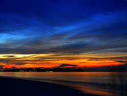
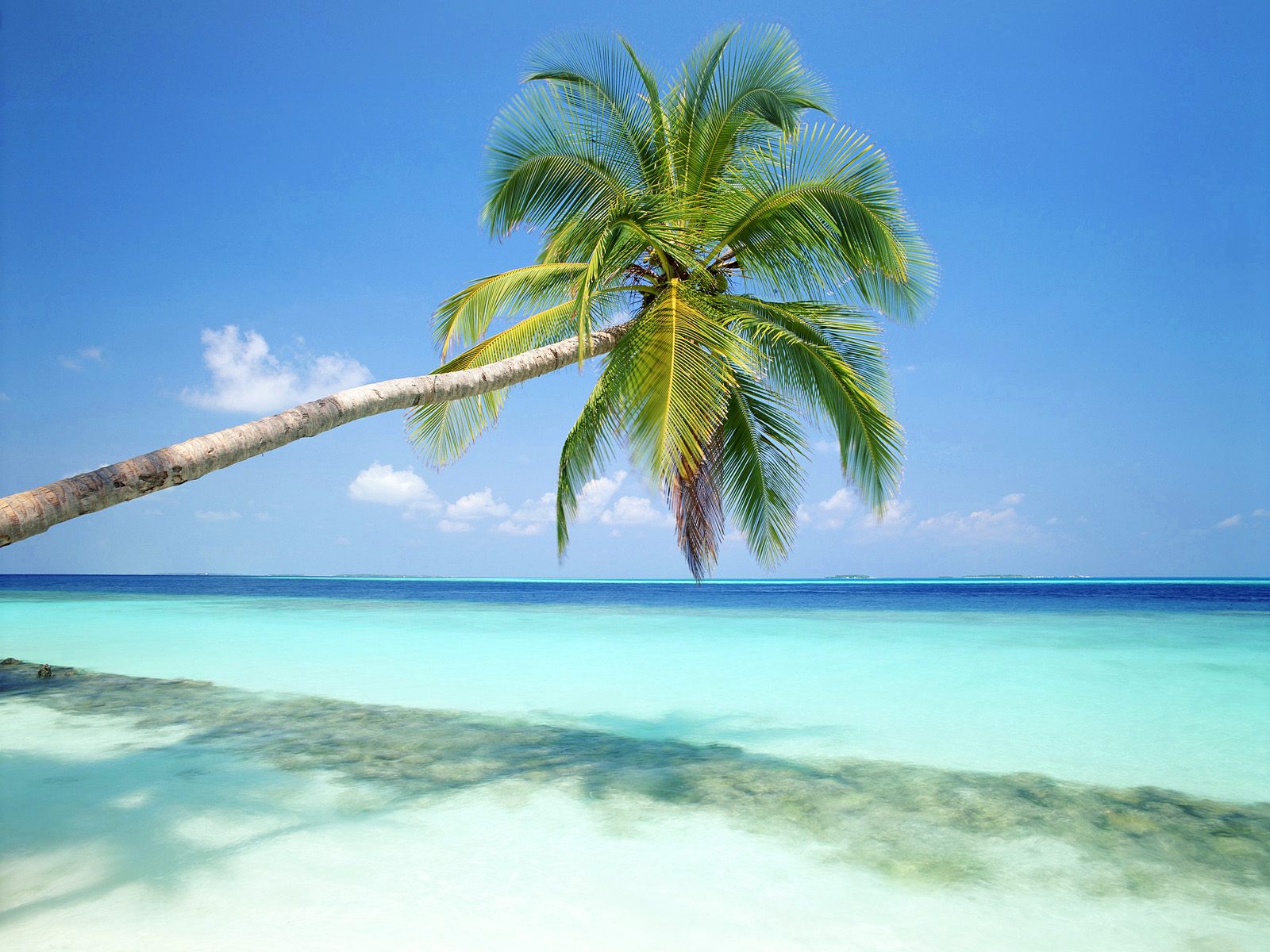
The Maldives consists of approximately 1,190 coral islands grouped in a double chain of 26 atolls, along the north-south direction, spread over roughly 90,000 square kilometers (35,000 sq mi), making this one of the world's most dispersed countries. It lies between latitudes 1°S and 8°N, and longitudes 72° and 74°E. The atolls are composed of live coral reefs and sand bars, situated atop a submarine ridge 960 kilometers (600 mi) long that rises abruptly from the depths of the Indian Ocean and runs north to south. Only near the southern end of this natural coral barricade do two open passages permit safe ship navigation from one side of the Indian Ocean to the other through the territorial waters of Maldives. For administrative purposes the Maldivian government organized these atolls into twenty one administrative divisions. The largest island of Maldives is Gan, which belongs to Laamu Atoll or Hahdhummathi Maldives. In Addu Atoll the westernmost islands are connected by roads over the reef (collectively called Link Road) and the total length of the road is 14 km (9 mi).

The Maldives is the lowest country in the world, with a maximum natural ground level of only 2.3 meters (7 ft 7 in), with the average being only 1.5 meters (4 ft 11 in) above sea level, although in areas where construction exists, this has been increased to several meters. More than 80 percent of the country's land, composed of coral islands are less than one meter above sea level.

The reef is composed of coral debris and living coral. This acts as a natural barrier against the sea, forming lagoons. Other islands, set at a distance and parallel to the reef, have their own protective fringe of reef. An opening in the surrounding coral barrier allows access to the calmer lagoon waters. The barrier reefs of the islands protect them from the storms and high waves of the Indian Ocean.

A 15 centimeters (6 in) thick layer of humus forms the top layer of soil. Below the humus layer are 60 centimeters (2 ft) of sandstone, followed by sand and then fresh water. Due to high levels of salt in the soil near the beach, vegetation is limited there to a few plants such as shrubs, flowering plants, and small hedges. In the interior of the islands, more vegetation such as mangrove and banyan grow. Coconut palms, the national tree, are able to grow almost everywhere on the islands and are integral to the lifestyle of the population.

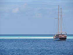
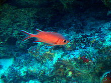
The limited vegetation and land wildlife is supplemented by the abundance of marine life. The waters around the Maldives are abundant in rare species of biological and commercial value. Tuna fisheries are one of the main commercial resources. The Maldives have an amazing diversity of sea life, with corals and over 2,000 species of fish, ranging from reef fish to reef sharks, moray eels, and a wide variety of rays: Manta rays, Stingray and Eagle ray. The Maldivian waters also host whale sharks and hawksbill and green turtles.

Tourism
Maldives was largely terra incognita for tourists until the early 1970s. Only 185 islands are home to its 300,000 population, while the other islands are used entirely for economic purposes of which tourism and agriculture are the most dominant. Tourism accounts for 28% of GDP and more than 60% of the Maldives' foreign exchange receipts. Over 90% of government tax revenue comes from import duties and tourism-related taxes. The development of tourism fostered the overall growth of the country's economy. It created direct and indirect employment and income generation opportunities in other related industries. The first tourist resorts were opened in 1972 with Bandos island resort and Kurumba Village.

According to the Ministry of Tourism, the emergence of tourism in 1972 transformed the economy, moving rapidly from dependence on fisheries to tourism. In just three and a half decades, the industry became the main source of income. Tourism was also the country's biggest foreign currency earner and the single largest contributor to the GDP. As of 2008, 89 resorts in the Maldives offered over 17,000 beds and hosted over 600,000 tourists annually.

Maldives' Firsts
·     Set a record in 2006 for the largest number of scuba divers participating in one dive, with a grand total of 958 divers descending into the water at the same time. This record was broken by Indonesia in 2009.
·     Opened the first virtual embassy, in the online world Second Life, on 22 May 2007.
·  Held the first cabinet meeting underwater. The meeting was chaired by President Mohamed Nasheed. In the meeting, the President, Vice President, and the cabinet signed a declaration calling for concerted global action on climate change, ahead of the UN climate conference in Copenhagen. The underwater meeting was part of a wider campaign by international environmental NGO 350.org.


Source, Images: http://en.wikipedia.org/wiki/Maldives

Weather in the Maldives

The Indian Ocean acts as a heat buffer, absorbing, storing, and slowly releasing the tropical heat. The temperature of Maldives ranges between 24 °C (75 °F) and 33 °C (91 °F) throughout the year. Although the humidity is relatively high, the constant cool sea breezes keep the air moving and the heat mitigated.

The weather in the Maldives is affected by the large landmass of South Asia to the north. The presence of this landmass causes differential heating of land and water. These factors set off a rush of moisture-rich air from the Indian Ocean over South Asia, resulting in the southwest monsoon. Two seasons dominate Maldives' weather: the dry season associated with the winter northeastern monsoon and the rainy season which brings strong winds and storms. The shift from the moist southwest monsoon to the dry northeast monsoon occurs during April and May. During this period, the northeast winds contribute to the formation of the northeast monsoon, which reaches Maldives in the beginning of June and lasts until the end of August. However, the weather patterns of Maldives do not always conform to the monsoon patterns of South Asia. The annual rainfall averages 254 centimeters (100 in) in the north and 381 centimeters (150 in) in the south.

Marine ecosystem
Maldives waters are home to several ecosystems, but are most noted for their variety of colorful coral reefs, home to 300 species of fish. Seven marine species have been described as new to science, while several more await description. Over 400 have been identified and catalogued and many are now held in the reference collection, including 5 species of sea turtles, 51 species of echinoderms, 5 species of sea grasses and 285 species of alga & sponges, crustaceans, and tunicates. About 200 coral species have been recorded to date, representing over 60 genera.

Among the many marine families represented are Pufferfish, Fusiliers, Jackfish, Lionfish, Oriental Sweetlips, reef sharks, Groupers, Eels and Snappers. Bannerfish, Batfish, Humphead Wrasse, Spotted Eagle Rays, Scorpionfish, Lobsters, Nudibranches, Angelfish, Butterflyfish, Squirrelfish, Soldierfish, Glassfish, Surgeonfish, Unicornfish, Triggerfish, Napoleon wrasses and Barracudas.

These coral reefs are home to a variety of marine ecosystems that vary from planktonic organisms to whale sharks. Sponges have gained importance as five species have displayed anti-tumor and anti-cancer properties.

1998 El Niño
In 1998, warming due to the El Niño phenomenon killed 2/3 of the nation's coral reefs due to bleaching. Coral reef bleaching is a "term suggested in place of "coral bleaching" because this condition is seldom limited to corals and most affected photo symbiotic hosts reside on coral reefs". Bleaching is the loss of photo symbiotic microorganisms (dinoflagellates, red and green algae, or cyanobacteria), or the pigments of these photosymbionts, or some of both, from tissues of host cnidarians, sponges, molluscs or other photosymbiotic host animals. The name comes from the whitening of many hosts which possess few pigments of their own.

The water temperature had been raised as much as 5 °C (41 °F) degrees. Several scientists placed electrified cones anywhere from 20–60 feet (6.1–18 m) below the surface. The cones created an attraction for coral larva to attach itself. In 2004, scientists witnessed corals regenerating. Corals began to eject pink-orange eggs and sperm. The growth of these electrified corals was five times faster than ordinary corals. Scientist Azeez Hakim stated, "before 1998, we never thought that this reef would die. We had always taken for granted that these animals would be there, that this reef would be there forever. El Niño gave us a wake-up call that these things are not going to be there forever. They help by removing and recycling the carbon-dioxide which in excess amounts can lead to global warming. Not only this, they also act as a natural barrier against the tropical storms, floods and tsunamis”. Seaweeds grow on the skeletons of dead coral. The corals reefs are like the rainforest for marine life.

2004 Tsunami
On 26 December 2004, following the 2004 Indian Ocean earthquake, the Maldives were devastated by a tsunami. Only nine islands were reported to have escaped any flooding, while fifty-seven islands faced serious damage to critical infrastructure, fourteen islands had to be totally evacuated, and six islands were destroyed. A further twenty-one resort islands were forced to close because of serious damage. The total damage was estimated at more than US$400 million, or some 62 percent of the GDP. A total of 108 people, including six foreigners, reportedly died in the tsunami. The destructive impact of the waves on the low-lying islands was mitigated by the fact there was no continental shelf or land mass upon which the waves could gain height. The tallest waves were reported to be 14 feet (4.3 m) high.


Source, Images: http://en.wikipedia.org/wiki/Maldives

Thursday, November 24, 2011

Tourism in the Maldives

Tourism is the largest economic industry in the Maldives, as it plays an important role in earning foreign exchange revenues and generating employment in the tertiary sector of the country. The archipelago of the Maldives is the main source of attraction to many tourists visiting the country worldwide.

Tourism began in the Maldives in the late 1900's. A United Nations mission on development which visited the Maldives Islands in the 1960s did not recommend tourism, claiming that the islands were not suitable. Ever since the launch of the first resort in Maldives in 1972, however, tourism in Maldives has flourished. The arrival of the first tourist group is estimated to have occurred in February 1972. The group landed at Malé, the capital island of the Maldives, and spent 12 days in the country. Tourism in Maldives started with just two resorts with a capacity of about 280 beds in Kurumba Village and Bandos. At present, there are over 80 resorts located in the different atolls constituting the Republic of Maldives. Over the past few decades, the number of tourists in Maldives has risen continuously. Today, more than 500,000 tourists visit the Maldives each year.

The number of resorts increased from 2 to 92 between 1972 and 2007. As of 2007, over 8,380,000 tourists had visited Maldives. Most visitors arrived at Malé International Airport, on Hulhulé Island, adjacent to the capital Malé. The airport is served by flights to India, Sri Lanka, Doha, Dubai, Singapore and major airports in South-East Asia, as well as of charters from Europe. Gan Airport, on the southern atoll of Addu, also serves an international flight to Milan several times a week.

Outside the service industry, Male is the only location where the foreign and domestic populations are likely to interact. The tourist resorts are not on islands where the natives live, and casual contacts between the two groups are discouraged.

Natural beauty
Maldives is very famous for its natural beauty which includes the blue ocean and white beaches, accompanied by clean air and pleasant temperatures. The climate of the Maldives is ideal for visitors to get engaged in water sports such as swimming, fishing, scuba diving, snorkeling, water-skiing and windsurfing.

Due to its extraordinary underwater scenery and clean water, Maldives is ranked among the best recreational diving destinations of the world. A tourist resort in the Maldives consists of an exclusive hotel on its own island, with its population entirely based on tourists and work force, with no local people or houses.

These islands developed for tourism are approximately 800 by 200 meters in size and are composed of sand and coral to a maximum height of about 2 meters above the sea. In addition to its beach encircling the island, each island has its own "house reef" which serves as a coral garden and natural aquarium for scuba divers and snorkelers. The shallow water enclosed by the house reef also serves as a large natural swimming pool and protects swimmers from the ocean waves and strong tidal currents outside the house reef.

The buildings on a typical resort includes rooms and suites reserved for use by its guests, restaurants, coffee shops, shops, lounges, bars, discos and diving schools. A portion of the island also contains staff lodgings and support services such as catering, power generators, laundry, and a sewage plant. On-island shops offer a wide range of products, such as souvenirs and artifacts. Most resorts offer a wide variety of activities such as aerobics, volleyball and table tennis.

Ecotourism in Maldives
Some promotion of ecotourism is practiced in the Maldives, with resorts emphasizing recycling of heat that is wasted in producing electricity and stricter policies of waste disposal. Furthermore, the government aims to conserve the natural beauty of the islands before they are being altered into resorts by enforcing laws such as prohibition of catching turtles and reduction in the damages caused to the coral reefs.

Nevertheless, the Maldives have frequently come under criticism for their lack of protection of the local shark populations, which have sharply decreased after being hunted extensively for decades. In some areas of the island, sharks have entirely disappeared. Sharks are hunted primarily for their fins. Shark fins are exported from the Maldives to other countries in Asia, where they are regarded as a delicacy. The fins are amputated from the live animals, which are then thrown back alive into the sea.

Although laws exist that prohibit this practice in the Maldives, these laws are not respected or enforced by the local authorities.


Source, Images: http://en.wikipedia.org/wiki/Tourism_in_the_Maldives

Friday, October 21, 2011

Thi Lor Sue Waterfall - Tak

The Umphang Thi Lor Sue Waterfall (also The Lor Sue, Thee Lor Sue or Te-law-zue) is claimed to be the largest and highest waterfall in Thailand. It stands 250 meters (820 ft) high and nearly 450 meters (1,480 ft) wide on the Mae Klong River, flowing down from Huai Klotho into the Umphang Wildlife Sanctuary in Tak Province in northwestern Thailand. However, the waterfall has apparently never been surveyed, as the figures given are approximate.   

In fact, to be pronounced "Thee Lor Sue" and as a noun in the Karen language means "Waterfall". The name "Thi Lo Sue" is an attempt to interpret each word "Thee" or "Thi" means "water", "Lo" or "Lor" means "fall", but "Sue" has no meaning similar, so it is trying to make as meaningful as "Su" means "black", thus leading to called "Thi Lor Su" which means "black waterfall".

Thi Lor Sue waterfall is one main reason people travel to Umphang. It is the largest waterfall of Thailand, containing many smaller drops combined together for a magnificent view. Its height is about 200 meters and total width is about 400 meters. It is most beautiful during rainy season from June to November because of the larger water flow. However during this period, the road access to the waterfall is closed for safety reason and some hiking is required. The peak season for tourism is in December and January where the water level is still high and the road to waterfall (25 km) is open for public. Only cars with four wheel drive can pass this steep and slippery road. An alternative way to reach the waterfall is by whitewater rafting downstream along the calm section of Klong River and then continue journey either on foot or by car for another about 12 km. Travelling this way, two waterfalls dropping into Klong River will be seen: Thi Lo Jo Waterfall (Thai: น้ำตกทีลอจ่อ), and Sai Rung Waterfall (Thai: น้ำตกสายรุ้ง). The name Thi Lo Sue, in Karen language, means giant waterfall or black waterfall.

Thi Lor Jo or Falling Rain waterfall is approximately 3 km from Umphang. The waterfall is divided into 2 tiers. The upper falls are located on a high cliff and the tier is narrow whereas the lower falls are part of the stream of the Klong River, falling like rain fall. It is possible to travel all year-round. It is only recently that Thi Lo Le Waterfall (Thai: น้ำตกทีลอเล) is promoted as an attraction for those who prefer adventure. It is a waterfall dropping directly into Klong River located deep in Thungyai Naresuan Wildlife Sanctuary with no road access. Only traveling with tour companies is possible. The journey to the waterfall typically involves white water rafting along Klong River of about 40 km through rapids of Class 4 or 5 while the journey back is usually by riding elephants. The trip takes 2 or 3 days.

Some other places of interests are Ta Ko Bi Cave (Thai: ถ้ำตะโค๊ะบิ), a cave formerly used by Communist Party of Thailand; Doi Hua Mot (Thai: ดอยหัวหมด), view point above cloud attitude; Ban Pa La Ta (Thai: บ้านปะละทะ), a Karen village dated back to over 250 years ago.

The rafting route begins from Ban Palata, follow the smooth flowing stream for approximately an hour. The first point is where the upper stream meets, Huai Klotho that come from Thi Lor Sue waterfall, that pass Ban Klotho. The banks of the river are full of green mountain forest. In some place, there are high mountain ranges stretching from Phawatu Mountain Range. The first rapid to be seen are Kaeng Lekati that are divided into 3 parts and extend for many kilometers. There are large rocks obstructing small river basin. The rapid that are the most difficult is Lekati 2.

Below the rapid, there is a narrow sand bank where it is possible to rest. From there, follow the river past a small waterfall on the right hand side surrounded by high cliff. Continuing on, there is an overhang that looks like a person’s face. The top is known as Phakhonmong. On the lower side is a stream that became a large set of rapids that is full of meanders.

There are also large rocks known a Kaeng Khonmong that are divided into 3 parts. There will be a wide river basin that has a large sandy bank. Continuing on, there are known large rapids and the river flows continuously onto the month of Huai Kachochita also known as Elephant Running Creek. There is an island in front of this area, which is suitable for camping overnight. After this is Kaeng Kachochile. Passing this, there is a large open space where the water flows toward a cliff resembling a cave on the edge of the river. A large waterfall tumbles down and there are vines and other plants hanging onto the cliff side. Ferns adorn the top of the limestone cliff. This is Thi Lor Lay waterfall, the final destination on the rafting route.


Source, Images: http://en.wikipedia.org/wiki/Umphang_Thee_Lor_Sue_Waterfall

Tuesday, October 18, 2011

Doi Inthanon National Park and its Waterfalls - Chiang Mai

Doi Inthanon (Thai: ดอยอินทนนท์) is the highest mountain in Thailand. It is located in Mae Chaem District. The mountain was also known in the past as Doi Luang (meaning big mountain) or Doi Ang Ka, meaning the crow's pond top. Near the mountain's base was a pond where many crows gathered. The name Doi Inthanon was given in honour of the king Inthawichayanon, one of the last kings of Chiang Mai, who was concerned about the forests in the north and tried to preserve them. He ordered that after his death his remains shall be placed at Doi Luang, which was then renamed.

Doi Inthanon is part of a mountain range separating Burma from Thailand also known as Loi Lar Mountain Range or Daen Lao Range. This range, the westernmost of the Shan Highland system, separates the Salween watershed from the Mekong watershed. Other high peaks of the Loi Lar Mountain Range are Doi Luang Chiang Dao (2,175 m), Doi Pui (1,685 m), and Doi Suthep (1,601 m).

In 1954, the forests around Doi Inthanon were preserved, creating Doi Inthanon National Park, as one of the original 14 National parks of Thailand. It covers 482.40 km². The park spreads from the lowlands at 800 m altitude up to the peak in 2,565 m, thus covering many climatic and ecological different parts, thus with a total of 362 it has the second highest number of bird species of any national park in Thailand. Geologically the mountain is a granite batholith in a north-south oriented mountain range. The second-highest peak of this range is Doi Hua Mod Luang at 2,340 m.

Doi Inthanon National Park (nickname: "the roof of Thailand") is located in Mae Chaem District, Chiang Mai Province, northern Thailand. It includes Doi Inthanon, the country's highest mountain. Established in 1972, is 482 square kilometres (186 sq mi) in size.
The park is situated approximately 60 kilometres (37 mi) from Chiang Mai. It includes Karen and Meo Hmong villages of about 4,500 people. Its elevation range between 800–2,565 metres (2,600–8,415 ft). There are a number of waterfalls such as the Mae Klang Falls, Wachirathan Falls, Siriphum Falls, and Mae Ya Falls. The park has varied climatic and ecological different sections.

Flora and fauna
Its flora includes evergreen cloud forest, sphagnum bog, and deciduous dipterocarp forest. There are some relict pines. With 383 avifauna species, it ranks second in number of bird species within Thailand's national parks.

Its lowlands below 800 meters in elevation are warm and very dry during the rain-free season, but the summit of Doi Inthanon, at 2,565 meters, has a climate more like Canada than Thailand. The temperature has been known to drop as low as -8 degrees C. and frosts are not unusual during the cool, dry season. January is the coldest month: an average nighttime temperature is 5.5 degrees C. At any season, Doi Inthanon is a comfortable reprieve from the heat of the lowlands. At altitudes above 1000 meters, rainfall exceeds 2500 mm, considerably more than at nearby Chiang Mai. Even in the dry season, November to April, there is rare but occasional rain or the summit may be shrouded in cloud for a part of the day; persistent mist is an important factor in the maintenance of moist forest there.

The various sub montane forest formations at higher elevations are a unique asset of the park. They have dominant species belonging to temperate climate families rather than tropical. The summit area supports the only red rhododendron in Thailand (R. delavayi); it blooms from December through February. There are also two white-blossomed species abundant on Doi Inthanon which are restricted to only a few other sites.

Where mists are persistent, the slopes carry a moist hill evergreen or 'cloud forest' with many epiphytes, plants which live on tree trunks and branches but do not receive their moisture and nutrients from the host tree as do true parasitic plants. Instead, they are nurtured by the accumulation of dust particles and humus around their 'root' area and the moisture retained there, augmented by frequent bathing in cloud and mist. Epiphytic orchids are also abundant, along with lichens, lianas and fern.

At mid-elevations, 800 - 1500 meters, two species of pine are present, Pinus merkusii mixed with dipterocarp in the lower range, and P. kesiya with oak and laurel on drier slopes in the upper range. The pines are thought to be a relic from a prehistoric cooler climatic period when flora from the Sino-Himalayan region migrated southward. At the mid-elevations of the park, much of the forest has been removed by the activities of swidden cultivators and the slopes have converted to fire climax grasslands.

Bird watching: Because of its broad altitudinal range and the cool climate of its upper reaches, the park supports the largest number of bird species of any site in Thailand. The Center for Wildlife Research at Mahidol University records a present total of 362 species and expects additions; Many at the summit are migrants from northern Asia. Species restricted to Doi Inthanon are Ashy-throated Warbler and an endemic race of the Green tailed Sunbird; the park is the only site where the Chestnut-bellied Rock thrush and the Yellow-bellied Flower pecker are known to over summer and probably breed. Over 190 bird species are listed as common to abundant. Bird lists are available at the Visitor Center and at Park Headquarters.

Places To See
Mae Klang Waterfall
Because of its easy access, this unusual waterfall has been visited by Thai people for many years and they continue to come in large numbers on any sunny day in the year to swim, picnic and relax in this beautiful setting. The rapids and waterfall spill over a wide exposure of granite and can be approached closely. Visitors are asked to exercise caution around the waterfall area and while swimming either above or below the falls. A well-maintained trail leads up the side of the waterfall, and continues to the Visitor Center and beyond.

Wachirathan Waterfall (Km 20.8)
On the lower slope of Doi Inthanon, near the Karen hill tribe village Ban Sop Had, are the Wachirathan waterfalls (Thai: น้ำตกวชิรธาร), where the Wachirathan (lit. "Diamond Creek") tumbles over a granite escarpment. The falls are reached by a short, easy trail from the parking area. Wachirathan waters tumble down granite escarpment, creating a misty veil of great beauty. Visitors should be very cautious: three people have fallen to their deaths while taking photographs. Just a short distance on the main road beyond Wachirathan is the small Karen hill tribe village, Ban Sop Had. Turn right just past the bridge and you will find the village a few hundred meters up the dirt access road.

Napamaytanidol Chedi (Km 41)
Continuing north of the main summit road, turn left at km 41.8 over a bridge on a paved road which leads to a magnificent chedi completed in 1989. These temples were built to honor the 60th birthday of the King Bhumipol and Queen in 1987 and 1992 respectively.

Summit of Doi Inthanon (Km 48)
The drive to the summit offers some fine views, especially during November and December, before the dry season haze has become well established. On your visit to the summit stupa containing the remains of King Inthawidhayanon, be sure to read the English translation on the back of the marble plaque nearby. Photographing any part of the radar station is forbidden, but visitors may take pictures freely of any other subject.

On the main road and opposite the summit Ranger Station is a sign in Thai marking a short, self-guided nature trail which descends to a sphagnum bog in a small karst depression. The bog area, which displays the red blossomed Rhododendron delavayi, comes nearest to a true montane forest formation and is a good location for bird-watching. If you continue around the bog and down a short distance, you will reach a memorial shrine marking the site of a helicopter crash which occurred in the mid-seventies and killed the first superintendent of this park.
Mae Ya Waterfall (14 km from Chom Thong)
Thought to be the highest in Thailand and is well worth the extra effort to get there. Park officials estimate that the Mae Ya River plunges more than 250 meters at this point. It is a beautiful, fanning cascade, dropping down an ever-widening series of steps – without a doubt, a photographic favourite.

Siriphum Waterfall
The Siriphum Waterfall (pronounced "see-ree-POOM") was an impressively tall waterfall that we noticed was accompanied by another thinner but just-as-tall companion waterfall. This was the third or uppermost of the major waterfalls on the way up to Doi Inthanon's peak (not counting the Sirithat Waterfall, which we didn't get to see), but we worked our way down from the top so it was our first waterfall stop in the park.

According the Thailand Tourism, the name of this falls came from a combination of Queen Sirikit and King Bhumipol. Thus, we also noticed some signs indicating this waterfall was referred to as Namtok Siribhum as opposed to Namtok Siriphum.


Sources, Images: http://en.wikipedia.org/wiki/Doi_Inthanon_National_Park, 
http://www.chiangmai-chiangrai.com/doi_inthanon_park.html

Thursday, September 29, 2011

Mae Surin National Park and Waterfall - Mae Hong Son

Mae Surin National Park is given national park status in 1981, this natural wonder, which straddles Mueang and Khun Yuam districts, encompasses a wildlife and botanical reserve, a huge waterfall and a spectacular terraced mountain. Namtok Mae Surin, its main attraction, is 37 kilometers from Khun Yuam district. It is a huge waterfall cascading over eighty meters down below.

Mae Surin national park is located in Mae Hong Son province, it covers 397 square kilometers of rugged terrain. It was established in 1981 as the 37th national park of Thailand. The park contains some of the main peaks of Thanon Tongchai range with elevation varying between 300 and 1,700 meters above sea level. These highland give birth to numerous streams and small rivers which are important tributaries of the Pai river, the main river of this region. 

The three seasons of northern Thailand offer varied conditions within Mae Surin National Park throughout the year. With the mountain tops and river valleys often wreathed in mist, the cold season (November to February) offers beautiful scenery, lush vegetation, and comfortable temperatures for hiking and camping. The temperature during the hot season (late February to May) can be somewhat oppressive in the lowlands of Mae Hong Son with a mean high temperature of 39ºC in the month of April. Rainy season is normally from June to October. This brings the forest into vibrant life and fills the rivers and their waterfalls to full capacity. While nature is at this time in its grandest state, hiking along the mountains will be quite difficult. Careful planning must be done for safety. White water rafting on Pai river is a popular activity during the rainy season. 

Drastic variations in topography and soil types in this region have created numerous habitat types ranging from sparsely vegetated stands of broadleaf deciduous to lush stands of tropical evergreen forest. Flora of interest are: increasingly rare stands of teak, stands of temperate pine, and a number of orchid and wildflower species. Probable animal species present in the park include Malay sun bear, golden cat, common wild pig, barking deer, and serow.

Mae Surin waterfall (Thai: น้ำตกแม่สุรินทร์), is a not-to-miss attraction in the park and is set amidst towering limestone mountains. A single jet of water leaping off a cliff face and plunging gracefully onto the rocks 100 meters below, Mae Surin waterfall is one of the tallest and most beautiful single tier waterfalls in Thailand. The fall can be viewed from the hills across the valley, or you can hike down the hills for a closer look. On the way to the waterfall, there are Karen and Hmong hill tribe villages as well as the famous Toong Bua Tong (Thai: ทุ่งบัวตอง), or fields of wild sunflowers, which bloom for two weeks only in the month of November.

The Park itself has two main locations with visitor facilities. The main Headquarters is located just North of Mae Hong Sorn along Route 1095 and beside the Pai River. At Mae Surin Waterfall, there is another information centre and visitor facilities. Both locations have accommodation available. The Headquarters has three bungalows overlooking the Pai river. At Mae Surin Waterfall, there are 2 new Bungalows and 2 basic Adobe huts available (There is no mainline electricity at this location. A generator provides electricity from Dusk until 22:00 hrs.). Both locations have camp grounds and tent rental.

The highlights of the Park include Mae Surin Waterfall, Doi Mae U-Kor, Mae Sakeud Nature Trail, Rafting and the Huay Fai Kor Wildlife Conservation Project.


Source: http://www.theworldwonders.com/asia/mae-surin.html

Followers