Tuesday, December 21, 2010

Similan Islands National Marine Park - Phang Nga

The Similan Islands (Thai: หมู่เกาะสิมิลัน) is a group of islands in the Andaman Sea off the coast of Phang Nga Province, southern Thailand. It is a national park which was established in 1982. It is considered the best place in Thailand for divers.

Similan Islands National Park was established after a one-year exploration by the forestry department. The park is an archipelago consisting of nine islands named Ko Bon, Ko Bayu, Ko Similan, Ko Payu, Ko Miang (two adjoining islands), Ko Payan, Ko Payang, and Ko Huyong. Recently, the park was expanded to included two remote islands named Ko Bon and Ko Tachai. The Similans are situated 70 kilometres from Phang Nga town. "Similan" is a Yawi word which means "nine". Similan is one of the most famous diving sites in Thailand, and noted as one of the top ten dive destinations according to the National Geographic Society.
The islands were created by upwellings of hot magma during the Tertiary-Cretaceous period some 65 million years ago, then smoothed by glacial ice and the erosion by the sea. The coral reefs are about 5000 years old and hence the oldest in Thailand. In 1982, the national park was established and now it is scheduled to become a UNESCO World Heritage Site.
Koh Similan
Koh Similan is the largest island. There are a total of 9 islands. The sea in the area has an average depth of 60 feet. Underwater it is full of rock formations and coral reefs in several shapes and forms, resembling such things as deer, leaves, brains, and mushrooms.
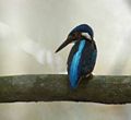
Above the water are found many diverse species such as the Nicobar Pigeon, Mangrove Monitor Lizards and more.
 Koh Huyong
Koh Huyong has the longest and widest beach in the park. However, the park prohibits any tourists from landing on the island as the beach a place where turtles come to lay their eggs.

Dive Sites
The Similan national park is famous for its dive sites. It has typically two different kinds of diving. East side diving consists of gently sloping coral reefs with sandy patches and the occasional boulder in between. The west side is known for its huge underwater granite boulders with numerous swimthroughs. Maybe the most famous east side dive site is East of Eden, off Island number 7. Elephant head rock is arguably the most famous west side dive site with a maze of swimthroughs and the reputation for spin-cycle like currents running in every direction.
Elephant head rock was named by Horst Hinrichs from Germany in the mid 70s, founder of one of the oldest dive shops in Phuket, Santana Diving. Other popular dive sites include North Point, Deep Six, Boulder City and the awesome pinnacles off Koh Bon and Koh Tachai.
The most important of all dive sites in the Similans, which is actually part of Surin National Park, is Richelieu Rock, famous for its incomparable variety and abundance of marine life. Whale shark sightings are not uncommon here.
However, since 1999, its once most beautiful dive site, the Fantasy Reef, has been closed from all diving activities after its condition had significantly deteriorated. Park chiefs officially blame diving for the deterioration, while dive operators in the area claim that fishing boats, with or without permission, enter the national park during low season, when no dive operators are allowed in the national park. The national park also claims that the dive site suffered significant damage from the tsunami in 2004, and continues to keep the reef closed. Since noone but the national park staff is allowed to dive Fantasy Reef it has been impossible to confirm that statement.
The nine granite islands are postcard perfect images of paradise, covered in tropical jungle and equipped with beaches of chalk-white sand. As if this was not enough, the views under the water surface are even more impressive - this is the best dive site in Thailand. Skin-Diver Magazine has acclaimed the Similans to be one of the ten most beautiful places in the world.
There is an enormous diversity in species - both in fish and corals. The visibility is the best you will find in Thailand. You will see plenty of colorful fish such as lionfish and clownfish (Nemo), and if you're lucky you may spot a bigger one like a manta or even a whale shark.
Wildlife Protection
Islands 1, 2 and 3 are closed for public due to turtle hatching protection program and reef conservation efforts. Island number 3 belongs to HM the Thai Princess. Fishing is banned in Similan and Surin National Park, however fishing boats are constantly seen in and around the Park. When diving, one can often find nets stuck to reefs and illegal fishing traps.
This season many illegal fishing traps have been found outside the most common dive sites, suggesting the fishermen are betting on divers not venturing off the known dive sites. They have contained among others Giant Trevallies, Batfish, Barracudas, Golden Pilot Jacks, Giant Triggerfish etc. The fishing traps seem to be overly abundant around Koh Bon and Koh Ta Chai.
Public awareness of this increasing problem will be the only way to change the situation so if you visit Similan and Surin National Parks and witness illegal fishing, please report your sightings. Public pressure and fear of lost revenue will eventually force the authorities to lean on the Rangers to actually do what they are supposed to do - protect the most beautiful and famous island group and dive sites in Thailand.
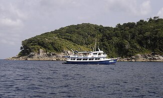
Access to the Similan Islands is easiest from Khao Lak, Phang Nga province. The mainland office is in Thap Lamu. Boats depart daily from November-May. The trip takes three hours each way on slow boats or 70 minutes via speedboat.
During the months November-May also live-aboard boats head to the Similan Islands. These dive boats depart and return from Khao Lak, Phuket and Ranong and stay for several days at the Similan National Marine Park.
High season in the Similans is from December until April, when the monsoon stays far away. The best period to visit is March, when the winds are calm and the water clear. The national park is closed from May 16 to November 15.


Sources: http://en.wikipedia.org/wiki/Similan_Islands, 
  http://wikitravel.org/en/Similan_Islands
Images: http://commons.wikimedia.org/wiki/Category:Similan_Islands

Tarutao National Marine Park - Satun

Tarutao National Marine Park (Thai: อุทยานแห่งชาติทางทะเลตะรุเตา) consists of 51 islands located in the Andaman Sea, off the coast of Satun Province of Southern Thailand. The Tarutao National Marine Park consists of two island groups: Tarutao (Thai: หมู่เกาะตะรุเตา) and Adang-Rawi (Thai: หมู่เกาะอาดัง-ราวี), which are scattered from 20 to 70 kilometers distance from the southwestern most point of mainland Thailand. The park covers an area of 1,490 square kilometers (1,260 ocean, 230 island). The southern most end of the Park lies on the border with Malaysia. Tarutao became Thailand's second marine national park on April 19, 1974. The coastal Khao Sam Roi Yot National Park had been designated in 1966.
The name Tarutao is a Thai corruption of its original Malay name, Pulau Tertua (the island of old).
There are essentially 7 islands of note in the Tarutao/Adang-Rawi archipelagoes:
  • Tarutao Archipelago (located approximately 30 km off the Thai coast)
    • Ko Tarutao (Thai: เกาะตะรุเตา) - The largest of the islands, Ko Tarutao is 26.5 km long, and 11 km wide. The highest point is over 2,000 feet. Forest covers over 60% of the island.
    • Ko Klang (Thai: เกาะกลาง), Ko Lek (Thai: เกาะเหล็ก)
  • Adang Archipelago (located approximately 45 km west of Tarutao)
    • Ko Adang (Thai: เกาะอาดัง), Ko Rawi (Thai: เกาะราวี), Ko Lipe (Thai: เกาะหลีเป๊ะ), Ko Dong (Thai: เกาะดง)
    • In the Adang Archipelago, the small (4 km²) island of Lipe is the most important. With water available year-round, it is the home of the largest permanent settlement, of approximately 800, and the gateway for boat transportation in and out of the Adang group.
History
The park was established in 1974. In 1982, it was listed as one of the original ASEAN Heritage Parks. It was also submitted to UNESCO for inclusion to the World Heritage in 1990, but its listing was deferred in the fifteenth session of the World Heritage Committee in 1991. The UNESCO requested a stronger management of the area.
The island had been used in the late 1930s as a penal colony for Thai political prisoners. During World War II, when support from the mainland was cut off, the guards and prisoners banded together and formed raiding parties on ships sailing through the waters near the island. After the pirates of Tarutao were eradicated by British forces at the end of the war, fishermen and farmers took up residence on the island.
Ko Tarutao was the setting for Survivor: Thailand, the 2002 season for the reality television series, Survivor. The Philippine version of the said series was also set there six years later.


Source: http://en.wikipedia.org/wiki/Tarutao_National_Marine_Park
Images: http://commons.wikimedia.org/wiki/Category:Koh_Tarutao

Dong Phaya Yen - Khao Yai Forest Complex - Nakhon Ratchasima

Dong Phaya Yen (Thai: ดงพญาเย็น, lit. Jungle of the Ice Lord) is a mountain range in central Thailand. Dong Phaya Yen is the southeastern extension of the Phetchabun mountains, dividing the Chao Phraya river valley of Central Thailand and the Khorat Plateau of the northeast. The mountain chain reaches a maximum altitude of 1,351 m above sea level at Khao Rom, its highest hill.
The range has a length of about 230 km. The southern arm of the Dong Phaya Yen Mountains is the Sankambeng range, that merges with the Dangrek Mountains on its eastern end. The mountains are drained to the north by several tributaries to the Mun River, while the south drains into the Prachinburi River.
Dong Phaya Yen was once known as Dong Phaya Fai or "Jungle of the Fire Lord" because this area was once the vast forest where malaria killed most travelers who dared to pass through the woods.
Much of the forest cover, however, was destroyed since the beginning of 20th century. Following the deforestation of the area, Vice King (Uparaja) Pinklao changed the name of the forest from Dong Phaya Fai to Dong Phaya Yen to imply that "the wild forest has been tamed".
Several national parks are located in the mountains. The most famous one is the Khao Yai National Park, which was the first national park of Thailand. Other parks are the Ta Phraya National Park at the boundary with Cambodia, the Thap Lan National Park, Pang Sida National Park, Phra Phutthachai National Park and the Dongyai Wildlife Sanctuary. Altogether 6155 km² are protected in these parks.
In 2005 the forests of the Dong Phaya Yen mountains were inscribed on the UNESCO World Heritage List under the name Dong Phaya Yen–Khao Yai Forest Complex.
Khao Yai National Park (Thai: เขาใหญ่) is a national park in Thailand. Khao Yai National Park is situated in the Sankambeng Mountain Range, the southern prolongation of the Dong Phaya Yen Mountains, at the southwestern boundary of the Khorat Plateau. This park lies largely in Nakhon Ratchasima Province (Khorat), but also includes parts of Saraburi, Prachinburi and Nakhon Nayok provinces.
The park is the second largest in Thailand. It covers an area of 2,168 square kilometers, including evergreen forests and grasslands. Its altitude mostly ranges from 400 to 1000 m above sea level. There are 3,000 species of plants, 320 species of birds like red junglefowl and green peafowl and 67 species of mammals, including Asiatic black bears, Asian elephants, gaur, tigers, gibbons, Indian sambar deer, crab-eating macaque, Indian muntjac, dholes, and wild pigs. Its waterfalls include the 80 metre Heo Narok, and Heo Suwat made famous from the film The Beach. Namtok Sarika is popular with the Thais.
Recent wildlife studies show that animal ranges, particularly the few resident tigers, are impacted by human activity near the center of the park. This study has not impacted the government's call for private lodging concessions within the park itself.
History
About a century ago the Ban Tha Dan people and the Baan Tachal people in the Nakhon Nayok Province to the south of Khao Yai built a settlement within the forest. Up to 30 households cultivated the land. The area was formally recognized by the government and classified as a sub-district known as Pak Ple.
However, due to its location and distance from authorities it became a refuge for criminals and fugitives. In an attempt to capture the fugitives the areas sub-district status was cancelled, and the villages relocated into the plains some 30 km away.
In 1959 the Prime Minister of Thailand, Marshall Sarit Thanarat, Coordinated the Ministry of Agriculture and the Ministry of the Interior to create a process where national parks could be established. Khao Yai National Park was then established on September 18, 1962, declared by royal proclamation in the Government Gazette (Book 79, Section 89) as the first National Park in Thailand. A major role in its establishment was received by Boonsong Lekakul, one of the 20th century's most famous conservationists in Thailand.
In 1984 the park was made an ASEAN Heritage Park, and on July 14, 2005 the park together with other parks in the Dong Phaya Yen mountains was inscribed as a UNESCO World Heritage Site under the name Dong Phaya Yen–Khao Yai Forest Complex.
Lands adjacent to the national park are becoming increasingly developed into luxury hotels and golf courses for weekending visitors from Bangkok. Such development limits wildlife corridors and permanently reduces future conservation and land acquisition ability.
Khao Yai National Park has three main seasons, with an annual mean temperature of 23 degrees celsius, though this varies greatly with the seasons.
Rainy Season Is from May to October. During this season most days have high rates of precipitation. The atmosphere is humid with average temperatures of 27 degrees celsius during the day dropping to 13 degrees celsius at night. Good waterfalls for travelers.
Cold season Is from November to February. Clear skies, sunny and cool. Average temperatures of 22 degrees celsius during the day and 10 degrees celsius at night. Good time for hiking.
Hot Season Is from March to April. Humid with day temperatures of 20-30 degrees celsius and 17 degrees celsius at night.
Limestones are present along the Dong Rek range. Sandstones outcrop in the south and north of the park. Shales and schist are also present. In the South, steep slopes made of granite and conglomerates can be seen.
There are four drainage areas in the park which are vital catchments for four river systems. The Takhong River drains from the central Khao Yai area and runs in a North-Easterly direction into the Mekong. The Sai Yai system drains from the Eastern Basin, turning sharply into the Southern Floodplains and on to the Gulf of Thailand. The Nakhon Nayok river system drains from the South-West watershed into the Nakhon Nayok Province to the South. The Saraburi Province drainage system drains Westward from the far West of the Khao Yai.
The park is often visited by travelers from Isan, Bangkok and beyond. The fee (per day) is 500 baht for foreigners (200 for children), and 50 for Thais.
  • Food is available from private concessions within the park.
  • Bicycles are available for hire from the park. Ask at the visitors center and they will direct you.
  • Kayaking and rafting services are also available.
  • Night-time "wildlife spotlighting" is available via pick-up trucks in the early evening. Animals sighted usually are limited to deer and civet cats, and only rarely include elephants.
  • Slide shows at the visitors center are available on weekends and public holidays at 10:00am, 14:00pm and 16:00pm.
  • Meeting rooms are available with audiovisual equipment for seminars and workshops.
  • Camping is permitted in camping zones. You may bring your own tent or hire one at the camping ground.
  • Lodges and cabins are available for singles and groups. Reservations are required.
Attractions
  • There are over 50 km of hiking trails. From easy to hard, one hour to three days. There trails on the map from the visitors center will only have the easier trails. Maps do come with English instructions. A guide is recommended for most trails if the tourist has no experience.
  • Kayaking and rafting.
  • Night time wildlife spotlighting.
  • Observation towers at Nong Pak Chee or Mo Sing. Early morning is the best time to view the Great Hornbills, guar, and sometimes elephants. Gibbons are most active in the early morning.
  • At about 5:30 at night thousands of wrinkled lipped bats emerge from a cave 3 km outside the northern gate to begin night time feeding. The bats fly in a ribbon pattern across the sky.
  • Klong Pa Kang-Wang Haew-Dinosaur Footprint. Four day trek to see a dinosaur footprint!
Waterfalls
  • Haew Narok Waterfall - The Haew Narok waterfalls are the largest waterfalls in the park. It is a three tiered structure that extends 150 meters from the top tier to the basal lake. The waterfall is located about 10 kilometers from the south gate along the central road through Khao Yai.
  • Haew Suwat Waterfalls - This waterfall runs over a 20 meter cliff into a large pool below. It is located to the about 8 km east of the visitors center and can be visited easily by car along one of the main easterly roads. It can also be reached by a 8 km hike from the visitors center (walk number 4) which takes about 4–7 hours. It is made up mainly of multiple layers of sandstone conglomerates with large interbeds of basalt.
  • Haew Sai Waterfalls - Haew Sai Waterfalls are located a 700 meters north of the Haew Suwat Waterfalls. It is 8 km east of the visitors centre and can also be reached vias car or by hike.
  • Haew Pratoon Waterfalls - Smaller waterfall that is about 1 km north of Haew Sai waterfall.
Haew Suwat in Rainy season


Sources: http://en.wikipedia.org/wiki/Khao_Yai_National_Park,      
  http://en.wikipedia.org/wiki/Dong_Phaya_Yen_Mountains
Images: http://commons.wikimedia.org/wiki/Category:Khao_Yai_National_Park

Monday, December 20, 2010

Wat Phra Kaew - Bangkok

The Wat Phra Kaew (Thai: วัดพระแก้ว, RTGS: Wat Phra Kaeo, English: Temple of the Emerald Buddha; full official name Wat Phra Si Rattana Satsadaram, Thai: วัดพระศรีรัตนศาสดาราม) is regarded as the most sacred Buddhist temple (wat) in Thailand. It is a "potent religio-political symbol and the palladium of Thai society". It is located in the historic centre of Bangkok (district Phra Nakhon), within the precincts of the Grand Palace.
The main building is the central ubosoth, which houses the statue of Emerald Buddha. The legendary history of this Buddha image is traced to India, five centuries after the Lord Buddha attained Nirvana, till it was finally enshrined in Bangkok at the Wat Phra Kaew temple in 1782 during Rama I's reign (1782–1809). This marked the beginning and raise of the Chakri Dynasty of the present Kingdom of Thailand (the present head of the dynasty is King Rama IX. The Emerald Buddha, a dark green statue, is in a standing form, about 66 centimetres (26 in) tall, carved from a single jade stone (Emerald in Thai means deep green colour and not the specific stone). It is carved in the meditating posture in the style of the Lanna school of the northern Thailand. Except for the Thai King, no other person is allowed to touch the statue. The King changes the cloak around the statue three times a year, corresponding to the summer, winter, and rainy seasons, an important ritual performed to usher good fortune to the country during each season.
While legend traces this statue to India, its rich historical records dates its finding in Cambodia in the 15th century, moved to Laos in the 16th century and then to Vientiane where it remained for 215 years, and finally to Thailand in the 18th century. Considering the long history and Nagasena's (a Brahmin who became a Buddhist sage and lived about 150 BC) prophesy that the Emerald Buddha would bring "prosperity and pre-eminence to each country in which it resides", the Emerald Buddha deified in the Wat Phra Kaew is deeply revered and venerated in Thailand as the protector of the country.
The earliest legend narrated to the ionic emerald image of the Buddha is that of Nagasena, a saint in India who with the help of Hindu god, Vishnu and demigod Indra got the Emerald Buddha image made, 500 years after Buddha attained Nirvana, from the precious stone of Emerald. Nagasena had, with his psychic powers predicted then that:
The image of the Buddha is assuredly going to give to religion the most brilliant importance in five lands, that is in Lankadvipa (Sri Lanka), Ramalakka, Dvaravati, Chieng Mai and Lan Chang (Laos).
As regards the historical legend of What Phra Kaew, it was originally known as the "Wat Pa Yia", (Bamboo Forest Monastery) in the Chiang Rai province of Northern Thailand. The What was struck by a lightning storm in 1434, when the octagonal Chedi broke up and revealed the Emerald Buddha (made of Jade), locally known as Phra Kaew Morakot. From there it was moved, initially to Vientianne and finally to Bangkok where it was deified in the temple by the original name, What Phra Kaew.
Another legend mentions that attempts made by the King of Chiang Mai to possess the statue after it was found in 1434; these failed thrice because the elephants transporting the statue refused to proceed beyond a crossroad in Lampang. The King of Chiang Mai considered the incident to be a strong divine directive and allowed the Buddha statue to remain in Lampang, where it remained for the next 32 years in an exclusively built temple.
Architecture
Wat Phra Kaeo has a plethora of buildings within the precincts of the Grand Palace, which covers a total area of over 94.5 hectares (234 acres). It has over 100 buildings with “200 years royal history and architectural experimentation” linked to it. The architectural style is named as Rattanakosin style (old Bangkok style). The main temple of the Emerald Buddha is very elegantly decorated and similar to the temple in ancient capital of Ayudhya. The roof is embellished with polished orange and green tiles, the pillars are inlaid in mosaic and the pediments are made of rich marble. The Emerald Buddha is deified over an elevated altar surrounded by large gilded decorations. While the upper part of this altar was part of the original construction, the base was added by King Rama III. Two images of the Buddha, which represent the first two kings of the Chakri dynasty, flank the main image.
Over the years, the temple has retained its original design. However, minor improvements have been effected after its first erection during Rama I's reign; wood-work of the temple was replaced by King Rama III and King Chulalongkorn; during King Mongkut's reign, the elegant doors and windows and the copper plates on the floor were additions, Rama III refurbished the wall painting (indicative of the universe according to Buddhist cosmology) and several frescoes that display the various stages of the Buddha's life; three chambers were added on the western side by King Mongkut; in the chamber known as 'Phra Kromanusorn' at the northern end, images of Buddha have been installed in honour of the kings of Ayudya; and in the 19th century, In Khong, a famous painter executed the wall murals. The entry to the temple is from the third gate from the river pier.
Other monuments
While the surrounding portico of the shrine is an example of Thai craftsmanship, the perimeter of the temple complex has 12 open pavilions. These were built during the reign of Rama I. There is plethora of monuments in the temple complex. These are:
Grand Palace: Please see detail in next post.

Pagodas: The temple grounds also depict three pagodas to its immediate north, which represent the changing centres of Buddhist influence. One such shrine to the west of the temple is the Phra Si Ratana Chedi, a 19th-century stupa built in Sri Lankan style enshrining ashes of the Buddha.
Library: Rama I also built a library in Thai style, in the middle of the complex, known as the "Phra Mondop". The library houses an elegantly carved Ayutthaya-style mother-of-pearl doors, bookcases with the Tripitaka (sacred Buddhist manuscripts), human-and dragon-headed nagas (snakes), and images of Chakri kings.
During the 19th century, the Royal Pantheon was built in Khmer style to the east of the temple, which is kept open for only one day in year, in the month of October to commemorate the founding of the Chakri dynasty.
Model of Angkor Wat: The temple complex also contains a model of Angkor Wat (the most sacred of all Cambodian shrines), that was started by King Mongkut and completed by King Nangklao (Rama III), as the Khmer empire of Cambodia and the Thais' share cultural and religious roots.
Hermit statue: A hermit's bronze image, which is believed to have healing powers, is installed in a sala on the western side of the temple. It is near the entry gate. It is a black stone statue, considered a patron of medicine, before which relatives of the sick and infirm pay respects and make offerings of joss sticks, fruit, flowers, and candles.
Nine towers: On the eastern side of the temple premises there are nine towers. They were erected during the reign of Rama I. Each tower is affixed with glazed tiles, with different colours for each tower, supposed to denote colours of the nine planets.
Elephant statues: Statues of elephants, which symbolize independence and power, are seen all around the complex. As Thai kings fought wars mounted on elephants, it has become customary for parents to make their children circumambulate the elephant three times with the belief that that it would bring them strength. The head of an elephant statue is also rubbed for good luck; this act of the people is reflected in the smoothness of the surface of elephant statues here.
The sacred temples in Thailand follow a dress code, which is strictly followed. Men must wear long pants and long-sleeved shirts and shoes; women must wear long skirts. Visitors who arrive dressed otherwise may rent appropriate clothing items at the entry area of the temple. It is compulsory to remove the shoes before entering the temple, as a sign of respect of the Buddha, as is the practice in all other temples in Thailand. While offering prayers before the Buddha image, the sitting posture should avoid any offensive stretching of feet towards the deity; the feet should be tucked in towards the back.


Source: http://en.wikipedia.org/wiki/Wat_Phra_Kaew
Images: http://commons.wikimedia.org/wiki/Category:Wat_Phra_Kaew

Grand Palace - Bangkok

The Grand Palace (Thai: พระบรมมหาราชวัง, Phra Borom Maha Ratcha Wang) is a complex of buildings in Bangkok, Thailand. It served as the official residence of the Kings of Thailand from the 18th century onwards. Construction of the Palace began in 1782, during the reign of King Rama I, when he moved the capital across the river from Thonburi to Bangkok. The Palace has been constantly expanded and many additional structures were added over time. The present King of Thailand, King Bhumibol Adulyadej, however, resides at the Chitralada Palace.
History
When King Buddha Yodfa Chulaloke (Rama I) decided to move the capital of Siam from Thonburi on the west to Bangkok on the east of the Chao Phraya River he decided to build a magnificent new palace as a place of residence as well as a centre of government. The area chosen was however occupied by Chinese merchants, whom he promptly asked to relocate (to the present day Yaowarat area).
The tower of gold began construction on 6 May 1782. At first the palace consisted of several wooden buildings surrounded on four sides with a high defensive wall of 1,900 metres in length, which encloses an area of 218,400 square metres. Soon the King ordered the building of the Temple of the Emerald Buddha; as the Monarch’s personal place of worship and royal temple. Once the palace was complete the King decided to under go a coronation ceremony to celebrate in 1785.
The plan of the Grand Palace followed closely that of the old palace in Ayutthaya. The Palace is rectangular shaped, with the western side next to a river and the royal temple situated to the east side, with all structures facing north. The palace itself is divided into three quarters: the outer quarters, the middle quarters and the inner quarters.
The palace became the centre of the Rattanakosin government and royal court for most of the early Chakri Dynasty until the reign of King Chulalongkorn (Rama V) who preferred to stay at the Dusit Palace, but still used the Grand Palace as an office and primary place of residence. This practice was followed by his sons (Rama VI and Rama VII) who preferred their own palaces. King Ananda Mahidol (Rama VIII) moved into the palace full time after his return from abroad in 1945. However after his mysterious death a year later in one of the palaces inside the complex, his brother King Bhumibol Adulyadej (Rama IX) who succeeded him decided to move permanently to the Chitralada Palace.
The Palace is however still very much in use; as many royal rituals are performed here by the King every year. Other royal ceremonies celebrated here are coronations; royal funerals, marriages and state banquets. The Palace grounds also contain the offices and buildings of the Bureau of the Royal Household, the Office of the Private Secretary to the King and Royal Institute of Thailand.
Architecture
The four structures surrounding the temple have history of their own. At the eastern end is the Borombhiman Hall (built in French architectural design), which was the residence of King Rama VI, now used as guest house for visiting foreign dignitaries. It has the dubious distinction of having been used as the operational headquarters and residence of General Chitpatima who attempted a coup, in 1981. The building to the west is the Amarindra hall, earlier a hall of Justice, now used for formal ceremonies. The Chakri Mahaprasat is the largest hall in the Grand Palace, built in 1882 by British architects, the architecture of which is fusion of Italian renaissance and Traditional Thai architecture. This style is called farang sai chadaa, (meaning: "Western in a Thai crown") as each wing has a shrine (mandap) crowned by a spire. Ashes of the Chakri kings (five ancestors) are enshrined in the largest of these shrines, also known as the pantheons, that were rebuilt after a fire in 1903 during Rama IV's reign. Ashes of the Chakri princess who could not become kings are enshrined in an adjoining hall. The throne room and the reception hall are on the first floor, while the ground floor houses a collection of weapons. The inner palace had the King’s harem (the practice was discontinued during King Rama VI's time who decreed the one wife rule), which was guarded by well trained female guards. Another hall in the palace is the 'Duist hall' in Ratanokosin-style, which runs from east to west, which was initially an audience hall but now converted into a funerary hall for the Royal family. Royal family corpses are kept here for one year before they are cremated in a nearby field. There is also a garden which was laid during rama IV's reign. The garden depicts a "Thai mountain-and-woods-fable" mountain scenes where the coming of age ritual of shaving the topknot of the Prince is performed.


Source: http://en.wikipedia.org/wiki/Grand_Palace
Images: http://commons.wikimedia.org/wiki/Category:Grand_Palace_Bangkok

Followers