Showing posts with label China. Show all posts

Tuesday, March 15, 2011

Jinzhaigou National Park - China

Jiuzhaigou National Park (pinyin: Jiǔzhàigōu; literally "Valley of Nine Villages"; Tibetan: Zitsa Degu) is a nature reserve in the north of Sichuan, a province in south western China. It is known for its many multi-level waterfalls and colorful lakes, and was declared a UNESCO World Heritage Site in 1992. It belongs to the category V (Protected Landscape) in the IUCN system of protected area categorization.
Known in English as Jiuzhai Valley it lies at the southern end of the Minshan mountain range, 330 km (205 mi) north of the provincial capital of Chengdu. It is part of the Jiuzhaigou County (formerly Nanping County) in the Aba Tibetan Qiang Autonomous Prefecture of northwestern Sichuan province, near the Gansu border.
The valley covers 720 km2 (278 sq mi), with buffer zones covering an additional 600 km2 (232 sq mi). Its elevation, depending on the area considered, ranges from 1,998 to 2,140 m (at the mouth of Shuzheng Gully) to 4,558 - 4,764 m (on Mount Ganzigonggai at the top of Zechawa Gully).
The climate is cool temperate with a mean annual temperature of 7.2 °C, with means of -1 °C in January and 17 °C in July. Total annual rainfall is 661 mm, 80% of which occurs between May and October.
History
The remote region was inhabited by various Tibetan and Qiang peoples for centuries, but was not officially discovered by the government until 1972. Extensive logging took place until 1979, when the Chinese government banned such activity and made the area a national park in 1982. An Administration Bureau was established and the site officially opened to tourism in 1984; layout of facilities and regulations were completed in 1987. The site was inscribed by UNESCO as a World Heritage Site in 1992 and a World Biosphere Reserve in 1997.
Since opening, tourist activity has increased every year: from 5,000 in 1984 to 170,000 in 1991, 160,000 in 1995, to 200,000 in 1997, including about 3,000 foreigners. Visitors numbered 1,190,000 in 2002. As of 2004, the site averages 7,000 visits per day, with a quota of 12,000 being reportedly enforced during high season. The Town of Zhangzha at the exit of the valley and the nearby Songpan County feature an ever-increasing number of hotels, including several polished five-stars, such as Sheraton.
Population
Jiuzhaigou (literally "Nine Village Valley") takes its name from the nine Tibetan villages along its length. Seven of them are still populated today. The main agglomerations that are readily accessible to tourists are Heye, Shuzheng and Zechawa along the main paths that cater to tourists, selling various handicrafts, souvenirs and snacks. There is also Rexi in the smaller Zaru Valley and behind Heye village are Jianpan, Panya and Yana villages. The Valley's no longer populated villages are Guodu and Hejiao.
Finally, the Penbu, Panxing and Yongzhu villages lie along the road that passes through the town of Jiuzhaigou/Zhangza outside the valley.
In 1997, the permanent population of the valley was about 1000, made up of about 130 Tibetan families. Due to the protected nature of the park, agriculture is no longer permitted so the locals now rely on tourism and local government subsidies to make a living.
Ecology
Jiuzhaigou's ecosystem is classified as temperate broad-leaf forest and woodlands, with mixed mountain and highland systems. Nearly 300 km2 (116 sq mi) of the core scenic area are covered by virgin mixed forests. Those forests take on attractive yellow, orange and red hues in the autumn, making that season a popular one for visitors. They are home to a number of plant species of interest, such as endemic varieties of rhododendron and bamboo.
Local fauna includes the endangered giant panda and golden snub-nosed monkey. Both populations are very small (less than 20 individuals for the pandas) and isolated. Their survival is in question in a valley subject to increasing tourism. Jiuzhaigou is also home to approximately 140 bird species.
Jiuzhaigou's landscape is made up of high-altitude karsts shaped by glacial, hydrological and tectonic activity. It lies on major faultlines on the diverging belt between the Qinghai-Tibet Plate and the Yangtze Plate, and earthquakes have also shaped the landscape. The rock strata is mostly made up of carbonate rocks such dolomite and tufa, as well as some sandstone and shales.
The valley includes the catchment area of three gullies (which due to their large size are often called valleys themselves), and is one of the sources of the Jialing River, part of the Yangtze River system.
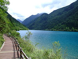
Jiuzhaigou's best-known feature is its dozens of blue, green and turquoise-colored lakes. The local Tibetan people call them "Haizi" in Chinese, meaning "son of the sea". Originating in glacial activity, they were dammed by rockfalls and other natural phenomena, then solidified by processes of carbonate deposition. Some lakes have a high concentration of calcium carbonate, and their water is very clear so that the bottom is often visible even at high depths. The lakes vary in color and aspect according to their depths, residues, and surroundings.
Some of the less stable dams and formations have been artificially reinforced, and direct contact with the lakes or other features is forbidden to tourists.
Notable features
Jiuzhaigou is composed of three valleys arranged in a Y shape. The Rize and Zechawa valleys flow from the south and meet at the centre of the site where they form the Shuzheng valley, flowing north to the mouth of the valley. The mountainous watersheds of these gullies are lined with 55 km (34 mi) of roads for shuttle buses, as well as boardwalks and small pavilions. The boardwalks are typically located on the opposite side of the lakes from the road, shielding them from disturbance by passing buses.
Most visitors will first take the shuttle bus to the end of Rize and/or Shuzheng gully, then make their way back downhill by foot on the boardwalks, taking the bus instead when the next site is too distant. Here is a summary of the sites found in each of the gullies.
Rize Valley
The 18 km (11 mi) long Rize Valley (pinyin: Rìzé Gōu) is the south-western branch of Jiuzhaigou. It contains the largest variety of sites and is typically visited first. Going downhill from its highest point, one passes the following sites:
-    The Primeval Forest (Yuánshǐ Sēnlín) is a preserved ancient woodland. It is fronted by spectacular views of the surrounding mountains and cliffs, including the 500 m high blade-shaped Sword Rock (Jiàn Yán).
-    Swan Lake (Tiān'é Hǎi) is a 2250 m long, 125 m wide picturesque lake named for its visiting swans and ducks.
-    Grass Lake (Cǎo Hǎi) is a shallow lake covered in intricate vegetation patterns.
-    Arrow Bamboo Lake (Jiànzhú Hǎi), covering an area of 170,000 m², is a shallow lake with a depth of 6 m. It lies at an elevation of 2,618 m, and was a main feature site for the 2002 Chinese film Hero.

-    Panda Lake (Xióngmāo Hǎi) features curious color patterns of blue and green. It empties into the multi-stream, multi-level Panda Waterfalls, dropping 78m in 3 steps.
-    Five Flower Lake (Wǔhuā Hǎi) is a shallow multi-colored lake whose bottom is criss-crossed by ancient fallen tree trunks.

-    Pearl Shoal (Zhēnzhū Tān) is a wide, gently sloping area of active calcareous tufa deposition covered in a thin sheet of flowing water. It empties into the famous Pearl Waterfalls, where the shoal drops 28 m in a 310 m wide broad curtain of water. A scene of the television adaptation of Journey to the West was filmed there.
-    Mirror Lake (Jìng Hǎi) is another quiet lake casting beautiful reflections of the surroundings when the water is calm.
Zechawa Valley
The Zechawa Gully (Zécháwā Gōu) is the south-eastern branch of Jiuzhaigou. It is approximately the same length as Rize gully (18 km ) but climbs to a higher altitude (3150 m at the Long Lake). Going downhill from its highest point, it features the following sites:
-    Long Lake (Cháng Hǎi) is the highest, largest and deepest lake in Jiuzhaigou, measuring 7.5 km (5 mi) in length and up to 103 m in depth. It reportedly has no outgoing waterways, getting its water from snowmelt and losing it from seepage. Local folklore features a monster in its depths.
-    Five-Color Pond (Wǔcǎi Chí) is one of the smallest but most spectacular bodies of water in Jiuzhaigou lakes. Despite its very modest dimensions and depth, it has a richly colored underwater landscape with some of the brightest and clearest waters in the area.
-    The Seasonal Lakes (Jìjié Hǎi) are a series of 3 lakes (Lower, Middle and Upper) along the main road, that change from empty to full during each year.
Shuzheng Valley
The Shuzheng Valley (Shùzhèng Gōu) is the northern (main) branch of Jiuzhaigou. It ends after 14.5 km (9 mi) at the Y-shaped intersection of the three gullies. Going downhill from the intersection to the mouth of the valley, visitors encounter the following:
-    Nuorilang Falls (Nuòrìlǎng Pùbù), near the junction of the valleys, are 20 m high and 320 m wide. They are reportedly the widest highland waterfall in China, and one of the symbols of Jiuzhaigou.
-    Nuorilang Lakes (Nuòrìlǎng Qúnhǎi) and Shuzheng Lakes (Shùzhèng Qúnhǎi) are stepped series of respectively 18 and 19 ribbon lakes formed by the passage of glaciers, then naturally dammed. Some of them have their own folkloric names, such as the Rhinoceros, Unknown, and Tiger lakes.
-    Sleeping Dragon Lake (Wòlóng Hǎi) is one of the lower lakes in the area. With a depth of 20 m, it is notable for the clearly visible calcareous dyke running through it, whose shape has been compared to a dragon lying on the bottom.
-    Reed Lake (Lúwěi Hǎi) is a 1375m-long, reed-covered marsh with a clear turquoise brook zigzaging through it. The contrast is particularly striking in the autumn when the reeds turn yellow.
Ecotourism
The Zharu Valley (Zārú Gōu) runs southeast from the main Shuzheng gully and is rarely visited by tourists. The valley begins at the Zharu Buddhist monastery and ends at the Red, Black, and Daling lakes.
Zharu Valley is the home of eco-tourism in Jiuzhaigou. The valley has recently been opened to a small number of ecotourists wishing to go hiking and camping off the beaten track. Visitors can choose from day walks and multiple day hikes, depending on their time availability. Knowledgeable guides accompany ecotourists through the valley, sharing their knowledge about the unique biodiversity and local culture of the national park. The Zharu Valley has 40% of all the plant species that exist in China and it is the best place to spot wildlife inside the national park.
The main hike follows the pilgrimage of the local Benbo Buddhists circumnavigating the sacred 4,528m Zha Yi Zha Ga Mountain.
The Fairy Pool (Shénxiān Chí) lies 42 km (26 mi) west of Jiuzhaigou and features travertine pools very similar to those of the nearby Huanglong Natural Reserve.
Jiuzhaigou, compared to other high-traffic scenic spots in China can be difficult to access by land. The majority of tourists reach the valley by a 10 hour bus ride from Chengdu along the Minjiang River canyon, prone to occasional minor rockslides and in the rainy season, mudslides that can add several hours to the trip. The new highway that had been constructed along this route was badly damaged during the May 12th 2008 earthquake but has now been repaired. Further repairs from Mao Xian to Chuan Zhu Si are still on going but the road is open to public buses and private vehicles.
Since 2003, it has been possible to fly from Chengdu or Chongqing to Jiuzhaigou Huanglong Airport on a 11,311 ft (3,448 m), high mountain side near Songpan County, and then take an hour-long bus ride to Huanglong, or a 90 minute bus ride to Jiuzhaigou. From 2006, a daily flight to Xi'an had been opened in peak season and new flights are being added all the time from different parts of China. In October 2009 new direct flights were added from Beijing, Shanghai and Hangzhou. Jiuzhaigou or Huanglong National Parks did not experience any damage during the earthquake of May 2008 and never closed after the event.

Source: http://en.wikipedia.org/wiki/Jiuzhaigou_Valley
Images: http://commons.wikimedia.org/wiki/Jiuzhaigou_Valley

Tuesday, December 14, 2010

Terracotta Army - China

The Mausoleum of the First Qin Emperor, Qin Shi Huang is the largest preserved one in China. It is a unique architectural ensemble whose layout echoes the urban plan of the capital, Xianyang, with the Imperial Palace enclosed by the walls of the city, themselves encircled by other walls. The mausoleum is also associated with an event of universal significance: the first unification of the Chinese territory in a centralized state created by an absolute monarch, in 221 BC.
Qin Shi Huang is a pivotal figure in Chinese history. After unifying China, he and his chief advisor Li Si passed a series of major economic and political reforms. He undertook gigantic projects, including the first version of the Great Wall of China, the now famous city-sized mausoleum guarded by a life-sized Terracotta Army, and a massive national road system, all at the expense of numerous lives. To ensure stability, Qin Shi Huang outlawed and burned many books.
The first Emperor of China, Qin Shi Huang (Ying Zheng: 221-210 BC) arranged for his burial place long before his accession to the seat of supreme power. When he became king of Qin in 247 BC, Zheng had his geomancers choose a favourable site at the foot of Mount Li. Work was commenced and was carried out more energetically with each new political and military success over his rivals Han, Zhao, Wei, Chu, Yan and Qi. Following the proclamation of the Empire of Ten Thousand Generations in 221, work at the burial place took on extraordinary dimensions.
After Qin Shi Huang's death, the principal craftsmen of the hypogeum were walled up on the orders of the second emperor, as a precaution against their betraying their secrets. The mausoleum, 35 km from Xian, is still landmarked by an imposing mound 43 m high. The interior is built within a first square enclosure, with doors in the middle of each of the four walls corresponding to the four cardinal points. This in turn is surrounded by a second rectangular enclosure running north-south.
The mausoleum's superstructures have disappeared and there remains only a wooded knoll resembling a truncated pyramid on a 350 m square base. While sinking a well 1.5 km from the exterior eastern wall of the mausoleum's inner room, three peasants from the small village of Yangeun-West came upon a pit in which there were lifesize terracotta statues of warriors. Excavations were begun immediately.
The Terracotta Army  (traditional Chinese; pinyin: bingma yong; literally "soldier and horse funerary statues") or the "Terra Cotta Warriors and Horses", is a collection of terracotta sculptures depicting the armies of Qin Shi Huang, the First Emperor of China. The figures, dating from 210 BC, were discovered in 1974 by some local farmers near Xi'an, Shaanxi province, China near the Mausoleum of the First Qin Emperor (Chinese; pinyin: Qin Shihuang Ling).
The figures vary in height 1.83–1.95 metres (6.0–6.4 ft), according to their roles, with the tallest being the generals. The figures include warriors, chariots, horses, officials, acrobats, strongmen and musicians. Current estimates are that in the three pits containing the Terracotta Army there were over 8,000 soldiers, 130 chariots with 520 horses and 150 cavalry horses, the majority of which are still buried in the pits.
The Terracotta Army was discovered in the spring of 1974 in the eastern suburbs of Xi'an, Shaanxi Province by a group of farmers who were digging a water well 1.5 miles (2.4 km) east of Mount Li. The region around the mountain was riddled with underground springs and watercourses. In 195 B.C., Liu Bang himself — the first emperor of the dynasty that followed the Qin — had ordered that 'twenty households' should move to the site of the mausoleum of the First Emperor of Qin (Qin Shi Huang, "shi huang" means the first emperor) to watch over the tomb. To this day, twenty villages sit in the immediate vicinity of the mausoleum, one of them the hamlet where the Yang family lived; the terracotta army may have been rediscovered by the direct descendants of the people left to guard it. For centuries, there were reports of pieces of terracotta figures and fragments of the Qin necropolis — roofing tiles, bricks, and chunks of masonry — having been occasionally dug up in the area.
This most recent discovery prompted archaeologists to investigate. The Terracotta Army is a form of funerary art buried with the First Emperor of Qin in 210-209 BC. The Army's purpose was to help rule another empire with Qin Shi Huang in the afterlife. Consequently, they are also sometimes referred to as "Qin's Armies." The material to make the terracotta warriors originated on Mount Lishan. In addition to the warriors, an entire man-made necropolis for the emperor has been excavated. Up to 5 metres (16 feet) of reddish, sandy soil had accumulated over the site in the centuries following its construction, but archaeologists also found evidence of earlier, impromptu discoveries. During the digs at Mount Li, archaeologists found several graves from the eighteenth and nineteenth centuries, whose diggers had obviously struck terracotta fragments, only to discard them as worthless with the rest of the back-filled soil.
Qin Shi Huang’s necropolis complex was constructed to serve as an imperial compound or palace. It comprises several offices, halls and other structures and is surrounded by a wall with gateway entrances. It was also said as a legend that the terracotta warriors were real soldiers, buried with Emperor Qin so that they could defend him from any dangers in the next life.
Construction
The terracotta army figures were manufactured in workshops by government laborers and by local craftsmen. The head, arms, legs and torsos were created separately and then assembled. Studies show that eight face moulds were most likely used, and then clay was added to provide individual facial features. Once assembled, intricate features such as facial expressions were added. It is believed that their legs were made in much the same way that terracotta drainage pipes were manufactured at the time. This would make it an assembly line production, with specific parts manufactured and assembled after being fired, as opposed to crafting one solid piece and subsequently firing it. In those times of tight imperial control, each workshop was required to inscribe its name on items produced to ensure quality control. This has aided modern historians in verifying that workshops that once made tiles and other mundane items were commandeered to work on the terracotta army. Upon completion, the terracotta figures were placed in the pits in precise military formation according to rank and duty.
The terracotta figures are life-like and life-sized. They vary in height, uniform and hairstyle in accordance with rank. The coloured lacquer finish, individual facial features, and actual weapons and armor from battle used in manufacturing these figures created a realistic appearance. The original weapons were stolen by robbers shortly after the creation of the army and the colouring has faded greatly. However, their existence serves as a testament to the amount of labor and skill involved in their construction. It also reveals the power the First Emperor possessed, enabling him to command such a monumental undertaking.
Pits: The four pits associated with the dig are about 1.5 km east of the burial ground and are about 7 metres deep. The outside walls of the tomb complex are as if placed there to protect the tomb from the east, where all the conquered states lay. They are solidly built with rammed earth walls and ground layers as hard as concrete. In addition to delineating the site, these served to protect the ground beneath the site from springs in the area, as also mentioned in the Shiji. Pit one, 230 metres long, contains the main army, estimated at 8,000 figures. Pit one has 11 corridors, most of which are over 3 metres wide, and paved with small bricks with a wooden ceiling supported by large beams and posts.
This design was also used for the tombs of noblemen and would have resembled palace hallways. The wooden ceilings were covered with reed mats and layers of clay for waterproofing, and then mounded with more soil making them, when built, about 2 to 3 metres higher than ground level. Pit two has cavalry and infantry units as well as war chariots and is thought to represent a military guard. Pit three is the command post, with high ranking officers and a war chariot. Pit four is empty, seemingly left unfinished by its builders.

According to current estimates, the statue army of the Qin Shi Huang Mausoleum must have represented the exact number of the imperial guards. Over the past thirteen years, discoveries have revealed the dimensions of the mausoleum, and the site constitutes one of the most fabulous archaeological reserves in the world.
Because of their exceptional technical and artistic qualities, the terracotta warriors and horses and the funerary carts in bronze are major works in the history of Chinese sculpture prior to the reign of the Han dynasty. The army of statues also bears unique testimony to the military organization in China at the time of the Warring Kingdoms (475-221 BC) and that of the short-lived Empire of a Thousand Generations (221-210 BC). The direct testimony of the objects found in situ (lances, swords, axes, halberds, bows, arrows, etc.) is evident.


Source: http://en.wikipedia.org/wiki/Terracotta_Army
Images: http://commons.wikimedia.org/wiki/Category:Terracotta_Army

Thursday, December 9, 2010

Forbidden City - China

The Forbidden City was the Chinese imperial palace from the Ming Dynasty to the end of the Qing Dynasty. It is located in the middle of Beijing, China, and now houses the Palace Museum. For almost five hundred years, it served as the home of emperors and their households, as well as the ceremonial and political center of Chinese government.

Built in 1406 to 1420, the complex consists of 980 buildings with 8,707 bays of rooms and covers 720,000 m2 (7,800,000 sq ft). The palace complex exemplifies traditional Chinese palatial architecture, and has influenced cultural and architectural developments in East Asia and elsewhere. The Forbidden City was declared a World Heritage Site in 1987, and is listed by UNESCO as the largest collection of preserved ancient wooden structures in the world.
Since 1925, the Forbidden City has been under the charge of the Palace Museum, whose extensive collection of artwork and artifacts were built upon the imperial collections of the Ming and Qing dynasties. Part of the museum's former collection is now located in the National Palace Museum in Taipei. Both museums descend from the same institution, but were split after the Chinese Civil War.
The common English name, "the Forbidden City", is a translation of the Chinese name Zijin Cheng  (literally "Purple Forbidden City"). Another English name of similar origin is "Forbidden Palace". The name "Zijin Cheng" is a name with significance on many levels. Zi, or "Purple", refers to the North Star, which in ancient China was called the Ziwei Star, and in traditional Chinese astrology was the abode of the Celestial Emperor. The surrounding celestial region, the Ziwei Enclosure, was the realm of the Celestial Emperor and his family. The Forbidden City, as the residence of the terrestrial emperor, was its earthly counterpart. Jin, or "Forbidden", referred to the fact that no-one could enter or leave the palace without the emperor's permission. Cheng means a walled city.
Today, the site is most commonly known in Chinese as Gugong , which means the "Former Palace". The museum which is based in these buildings is known as the "Palace Museum" (Chinese: Gugong Bowuyuan).
History
The site of the Forbidden City was situated on the Imperial City during the Mongol Yuan Dynasty. Upon the establishment of the Ming Dynasty, the Hongwu Emperor moved the capital from Beijing in the north to Nanjing in the south, and ordered that the Yuan palaces be burnt down. When his son Zhu Di became the Yongle Emperor, he moved the capital back to Beijing, and construction began in 1406 of what would become the Forbidden City.
Construction lasted 15 years, and required more than a million workers. Material used include whole logs of precious Phoebe zhennan wood found in the jungles of south-western China, and large blocks of marble from quarries near Beijing. The floors of major halls were paved with "golden bricks", specially baked paving bricks from Suzhou.
From 1420 to 1644, the Forbidden City was the seat of the Ming Dynasty. In April 1644, it was captured by rebel forces led by Li Zicheng, who proclaimed himself emperor of the Shun Dynasty. He soon fled before the combined armies of former Ming general Wu Sangui and Manchu forces, setting fire to parts of the Forbidden City in the process. By October, the Manchus had achieved supremacy in northern China, and a ceremony was held at the Forbidden City to proclaim the young Shunzhi Emperor as ruler of all China under the Qing Dynasty. The Qing rulers changed the names on some of the principle buildings, to emphasise "Harmony" rather than "Supremacy", made the name plates bilingual (Chinese and Manchu), and introduced Shamanist elements to the palace.
After being the home of 24 emperors — fourteen of the Ming Dynasty and ten of the Qing Dynasty — the Forbidden City ceased being the political centre of China in 1912 with the abdication of Puyi, the last Emperor of China. Under an agreement with the new Republic of China government, Puyi remained in the Inner Court, while the Outer Court was given over to public use, until he was evicted after a coup in 1924. The Palace Museum was then established in the Forbidden City in 1925. In 1933, the Japanese invasion of China forced the evacuation of the national treasures in the Forbidden City. Part of the collection was returned at the end of World War II, but the other part was evacuated to Taiwan in 1947 under orders by Chiang Kai-shek, whose Kuomintang was losing the Chinese Civil War. This relatively small but high quality collection was kept in storage until 1965, when it again became public, as the core of the National Palace Museum in Taipei.
After the establishment of the People's Republic of China in 1949, some damage was done to the Forbidden City as the country was swept up in revolutionary zeal. During the Cultural Revolution, however, further destruction was prevented when Premier Zhou Enlai sent an army battalion to guard the city.
The Forbidden City was declared a World Heritage Site in 1987 by UNESCO as the "Imperial Palace of the Ming and Qing Dynasties", due to its significant place in the development of Chinese architecture and culture. It is currently administered by the Palace Museum, which is carrying out a sixteen-year restoration project to repair and restore all buildings in the Forbidden City to their pre-1912 state.
Description
The Forbidden City is the world's largest surviving palace complex and covers 72 ha (hectares, 178 acres). It is a rectangle 961 metres (3,153 ft) from north to south and 753 metres (2,470 ft) from east to west. It consists of 980 surviving buildings with 8,707 bays of rooms. The Forbidden City was designed to be the centre of the ancient, walled city of Beijing. It is enclosed in a larger, walled area called the Imperial City. The Imperial City is, in turn, enclosed by the Inner City; to its south lies the Outer City.
The Forbidden City remains important in the civic scheme of Beijing. The central north-south axis remains the central axis of Beijing. This axis extends to the south through Tiananmen gate to Tiananmen Square, the ceremonial centre of the People's Republic of China. To the north, it extends through the Bell and Drum Towers to Yongdingmen. This axis is not exactly aligned north-south, but is tilted by slightly more than two degrees. Researchers now believe that the axis was designed in the Yuan Dynasty to be aligned with Xanadu, the other capital of their empire.
Religion was an important part of life for the imperial court. In the Qing Dynasty, the Palace of Earthly Harmony became a place of Manchu Shamanist ceremony. At the same time, the native Chinese Taoist religion continued to have an important role throughout the Ming and Qing dynasties. There were two Taoist shrines, one in the imperial garden and another in the central area of the Inner Court.
Another prevalent form of religion in the Qing Dynasty palace was Buddhism. A number of temples and shrines were scattered throughout the Inner Court, including that of Tibetan Buddhism or Lamaism. Buddhist iconography also proliferated in the interior decorations of many buildings. Of these, the Pavilion of the Rain of Flowers is one of the most important. It housed a large number of Buddhist statues, icons, and mandalas, placed in ritualistic arrangements.
While development is now tightly controlled in the vicinity of the Forbidden City, throughout the past century uncontrolled and sometimes politically motivated demolition and reconstruction has changed the character of the areas surrounding the Forbidden City. Since 2000, the Beijing municipal government has worked to evict governmental and military institutions occupying some historical buildings, and has established a park around the remaining parts of the Imperial City wall. In 2004, an ordinance relating to building height and planning restriction was renewed to establish the Imperial City area and the northern city area as a buffer zone for the Forbidden City. In 2005, the Imperial City and Beihai (as an extension item to the Summer Palace) were included in the shortlist for the next World Heritage Site in Beijing.
Depiction in art, film, literature and popular culture
The Forbidden City has served as the scene to many works of fiction. In recent years, it has been depicted in films and television series. Some notable examples include:
The Forbidden City (1918), a fiction film about a Chinese emperor and an American.
The Last Emperor (1987), a biographical film about Puyi, was the first feature film ever authorised by the government of the People's Republic of China to be filmed in the Forbidden City.
Marco Polo a joint NBC and RAI TV miniseries broadcast in the early 1980s, was filmed inside the Forbidden City. Note, however, that the present Forbidden City did not exist in the Yuan Dynasty, when Marco Polo met Kublai Khan.


Source: http://en.wikipedia.org/wiki/Forbidden_City
Images: http://commons.wikimedia.org/wiki/Category:Forbidden_City

Followers