Showing posts with label Islands and National Marine Parks. Show all posts

Tuesday, August 2, 2011

Koh Samui - Surat Thani

Ko Samui island of Surat Thani Province (or Koh Samui, Thai: เกาะสมุย), or often, simply Samui as it is referred to by locals, is an island off the east coast of the Kra Isthmus in Thailand, close to the mainland Surat Thani town. It is Thailand's second largest island, with an area of 228.7 km2 and a population of over 50,000 (2008). It is rich with natural resources, white sandy beaches, coral reefs and coconut trees.
History
The island was probably first inhabited about 15 centuries ago, settled by fishermen from the Malay Peninsula and Southern China. It appears on Chinese maps dating back to 1687, under the name Pulo Cornam. The name Samui is mysterious in itself. Perhaps it is an extension of the name of one of the native trees, mui, or from the Malay word Saboey, meaning "safe haven". Ko is the Thai word for "island".
Until the late 20th century, Ko Samui was an isolated self-sufficient community, having little connection with the mainland of Thailand. The island was even without roads until the early 1970s, and the 15 km journey from one side of the island to the other involved a whole-day trek through the mountainous central jungles.
Ko Samui has a population of about fifty-five thousand (source: Samui Mayor's Office) and is based primarily on a successful tourist industry, as well as exports of coconut and rubber. It even has its own international airport, Samui Airport, with flights daily to Bangkok and other major airports in Southeast Asia such as Hong Kong and Singapore. Whilst the island presents an unspoiled image to the public perception, economic growth has brought not only prosperity, but changes to the island's environment and culture, a source of conflict between local residents and migrants from other parts of Thailand and other countries. Reflecting Samui's growth as a tourist destination, the Cunard ship MS Queen Victoria (a 2000-plus passenger ship) docked at Samui during its 2008 world cruise.
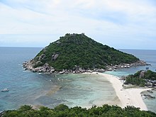
Ko Samui is located in the Gulf of Thailand, about 35 km northeast of Surat Thani town (9°N, 100°E). The island measures some 25 km at its widest point. It is surrounded by about sixty other islands, which compose the Ang Thong Marine National Park (Mu Ko Ang Thong National Park) and include other tourist destinations (Ko Phangan, Ko Tao and Ko Nang Yuan).
The central part of the island is an almost uninhabitable jungle mountain, Khao Pom, peaking at 635 m. The various lowland areas are connected together by a single 51 km road, running mostly along the coast to encircle the bulk of the island.
The old capital is Nathon, on the southwest coast of the island. It remains the major port for fishing and inter-island transportation. Nathon is the seat of the regional government, and the true commercial hub of the Samui locals. It has a charming pace, and is almost small enough to walk everywhere. The old Chinese shop houses along the middle street whisper of an exotic history.
Each of Samui's primary beaches is now also nominally considered as a small town, due to the number of hotels, restaurants and nightlife that have sprung up in recent years.
Ko Samui, being in Surat Thani Province, has essentially two seasons; warm and tropical most of the year, with a short rainy season. Unlike Phuket and most of the rest of Southern Thailand which has a 6-month rainy season between May and November, Samui's weather is relatively dry for the vast majority of the year, with the rainy season being primarily confined to November. For the rest of the year, since the weather is tropical, when it does rain, it usually doesn’t last long; rain showers of 20–60 minutes are typical.
Historically the island's economy has been based around subsistence agriculture and fishing, with coconuts as the main cash crop. From the 1980s onwards, tourism has become an economic factor and is now the dominant industry. The construction of a stable, high-speed internet connection in recent years has also made the island a feasible location for IT-based enterprises, which are beginning to provide a certain degree of economic diversity. The island's climate and accessibility make it particularly attractive for international investors.
Transportation
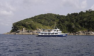
Ko Samui Airport (USM) is a private airport originally built by Bangkok Airways, which is still the main operator and was for a long time the only airline with services to Ko Samui from mainland Thailand. The airport is additionally served by Thai Airways International. Several ferries connect the island with the mainland, including the car ferry from Don Sak to a pier in the west of the island, south of the main town Nathon. Public buses to all parts of the mainland operate from a small bus station located in the south of Nathon. Songthaews (tuk-tuk style buses) circle the ring road, and private taxis are available throughout the island although these are often criticized for failure to use meters and flagrant overcharging.
Lifestyle
Although Ko Samui is in southern Thailand, where Islam has a strong influence, the original inhabitants of the island, known as 'Chao Samui', are predominantly Buddhist. In the past, most of the locals made their living in the coconut farming business. Nowadays, however, most work in jobs related to tourism.
Many locals have become wealthy from selling off land they have owned for decades. As a result of the extensive development of the island, many Thai-Chinese have come to Samui from the capital of Bangkok (Khung-Thep). Most of the manual labor needed to keep up with the island’s growth has been provided by people native to the country’s poorer north-eastern region. As a result, there is a wide cross section of economic classes on the island.
The south of Thailand is a melting pot of Buddhists, Thai Chinese, Muslims and traditional sea-faring gypsies. Ko Samui does not seem to suffer from the religious tensions in communities along the southern border of Thailand, and in general the locals live in harmony. Outside of the tourist areas, the Thai language is spoken with a thick Southern dialect which can be difficult even for northern Thais to understand.
With this broad mixture of cultures, Ko Samui is always celebrating some tradition or another, including some western ones.
Resorts & bungalows
After the exploding tourism in Ko Samui there has been a growth in building resorts, bungalows and luxury private villas on the island. This economic growth has led many businessmen from all over the world to invest in Ko Samui. With over 260 resorts and bungalows in Samui, counting from the end of year 2009, it has become Thailand's second largest resort business behind Bangkok and surpassing Phuket.
Events and festivals
Buffalo Fighting Festival One of the best-known festivals on Ko Samui is its Buffalo Fighting Festival, which is held on special occasions such as New Years Day and Songkran. Unlike Spanish bull-fighting, the fighting on Ko Samui is fairly harmless. The fighting season varies according to some ancient customs and ceremonies. The buffalo are beautifully decorated with ribbons and gold-painted leaves. Before the contest which lasts just two rounds, monks spray them with holy water. The winning owner typically takes home millions of baht in prize money.
Ten Stars Samui Art Party A recurring cultural event bringing together art lovers, local Thai and international artists and their new, original artworks. These bi-monthly events, hosted at various high-end resorts and other 5-star venues on the island, focus on building the art community on Ko Samui with presentations by featured artists.
Bowling Championship This is an annual bowling event held in May every year.
Avis Samui Tennis Open The annual amateur tennis tournament held in July.
The Fisherman's Village Festival This five-day festival is celebrated with fun, music and food. The music is usually played by well-known artists and food tents sell inexpensive cuisine provided by local hotels.
Triathlon Event The International Triathlon Union organizes this event every year. This event in Ko Samui draws more than five hundred participants from around the world. The event attracts competitors and visitors as well as locals. This event actually has never taken place and was promoted via a website only.
Samui Regatta The Samui Regatta is a sailing tournament, held every year. The tournament is internationally known and competitors come from as far away as Australia, Singapore, Japan and China. This event, for boats of all sizes and shapes, began in 2002.
Local food
In general, Southern Thai food is renowned for its spiciness. Much of the cuisine has its origins in Malay, Indonesian and Indian food. Favorite dishes from the south include Indian-style Muslim curry (massaman), rice noodles in fish curry sauce (Khanom Jeen) and chicken biryani.
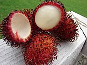
Local food in Ko Samui and its province of Surat Thani are salted eggs and rambutan.
There are four international private hospitals on Samui, Samui International Hospital on the Beach Road in north Chaweng, Thai International off the Lake Road in Chaweng, Bandon Hospital on the ring road and Bangkok Samui Hospital in Chaweng Noi. The Government Hospital is in Nathon. There are also numerous clinics and pharmacies, especially at Chaweng Beach.
There are many retirees living on Ko Samui, making it a popular destination for retirement in Thailand. This is probably due to the climate, natural surroundings, and ease of living on the island.

Source: http://en.wikipedia.org/wiki/Ko_Samui
Images: http://commons.wikimedia.org/wiki/Category:Ko_Samui

Wednesday, April 20, 2011

Koh Tao - Surat Thani

Ko Tao (also often Koh Tao, Thai: เกาะเต่า, lit. "Turtle Island") is an island in Thailand located near the western shore of the Gulf of Thailand. It covers an area of about 21 km². Administratively it forms a tambon within the district (Amphoe) Ko Pha Ngan of Surat Thani Province. As at end 2006 its official population is 1382. The main settlement is Ban Mae Hat.
The economy of the island is almost exclusively centered around tourism, especially scuba diving.
Ko Tao was named by its first settlers for the island's turtle-like geographic shape. Coincidentally, the island is an important breeding ground for Hawksbill turtles and Green turtles. Development of tourism has negatively impacted the health of these grounds but a breeding program organized in 2004 by the Royal Thai Navy and KT-DOC, a coalition of local scuba diving centers has reintroduced hundreds of juvenile turtles to the island's ecosystem.
Initially the island was not inhabited, there was only the occasional fisherman from the neighboring islands, looking for shelter in a storm or just taking a break before continuing his tiresome journey.
It would appear from old maps (1600-1850) and descriptions that this island was known by European cartographers and mariners as "Pulo Bardia". The best example is a map by John Thornton dated 1685. Page 383 of 'The Edinburgh Gazetteer, or Geographical Dictionary' (1822) also mentions the island and provides a geographical position. In his book titled "Narrative of a residence at the capital of the Kingdom of Siam" by Frederick Arthur Neale (1852 p. 120) he describes the people and wildlife of Bardia. According to the account there were farms and even cows in a village on the bay lying to the west side of the island - (probably Sairee?). The book includes a fanciful illustration of 'Bardia' showing huts and palm trees.
On June 18, 1899 King Chulalongkorn visited Ko Tao and left as evidence his monogram on a huge boulder at Jor Por Ror bay next to Sairee Beach. This place is still worshiped today.
In 1933 the island started to be used as a political prison. In 1947 Khuang Abhaiwongse, prime minister at that time, pleaded and received a royal pardon for all prisoners on the island. Everybody was taken to the shore of Surat Thani and Ko Tao was abandoned again.
In the same year Khun Uaem and his brother Khun Oh reached Ko Tao from the neighboring Ko Phangan by trying out their traditional sail boat, for that time a quite long and dangerous journey. Even though the island was still under royal patronage, it did not stop these pioneers claiming themselves a good part of the land on today's Sairee beach. Having brought their families over, they began to cultivate and harvest the excellent soil, forming the first generation of the present-day community. They lived a simple and tough life harvesting coconuts, fishing and growing vegetables, which were also traded with Ko Pha Ngan. Despite the difficulties in reaching the island, the population grew steadily.
In the 1980s the first travelers discovered Ko Tao and their special backpacker network quickly made it widely known and a popular destination. As a consequence, bigger, faster and safer boats were used to allow easier access to Ko Tao. In the 1990s the island finally became known as a diving site.
Tourism
The island is well known for scuba diving and snorkeling. Also offers some hiking, rock climbing and bouldering. The most popular place for tourists is Sairee on the West coast, which has a white sandy beach of 1.7 km interrupted only by a few huge boulders and a scattering of medium budget resorts and restaurants. Chalok Baan Khao, to the south of the island is becoming increasingly popular as an alternative for those wishing to escape the crowds. A multitude of beautiful granite boulders, which nestle both in the forests and on the beaches of Ko Tao, attract a growing number of climbers who visit each year to enjoy the adventurous aspect of their sport.
Ko Tao is less developed than Ko Samui and Ko Pha Ngan, but has become increasingly popular especially with the mid-20's backpacker crowd in search of relatively inexpensive scuba diving certification. For the last two years the demographics of the island has seen a age increase with many of the visitors that first visited the island over ten years ago are now for the first time returning with their families.
As of December 2005, Ko Tao had about 150 resorts offering accommodation and approximately 50 bars/clubs. Most of the resorts are still bungalow-style, not hotel/resort style. As of 2007 there is a trend to more up-market resorts which do not concentrate singularly on diving. Free WiFi is provided in increasing numbers and even the first sailing charter company on Ko Tao has opened.
Ko Tao is increasingly becoming a mecca for game fishermen on a budget. Species targeted include marlin, sailfish, king mackerel, cobia, baracuda, trevally and snapper.
Diving conditions have improved dramatically in the past few years with the continuing education of locals by the dive community. The El Nino weather pattern of 1997 caused a warming of the waters which resulted in the loss of a great deal of the shallow corals near the island. Since then, the recovery has been swift and dramatic. And with help by island conservation groups the island environmental outlook is strong.
Chumpon Pinnacle, a dive site to the west of the island has a reputation for divers in search of both whale sharks and bull sharks. However, because of the warmer water temperatures over the last year a great amount of bull sharks have migrated to cooler waters.
Transportation
With few exceptions, almost all roads on Ko Tao are dirt roads and generally are in poor shape. However, new roads are being paved at a quick rate. 95% of all traffic on the island is motorbike, with mopeds and dirt bikes being the main mode of transport. Motor bike accidents are the most common injury on the island. Poor roads, sand, reckless taxi drivers and drunkenness are all a factor.
Ko Tao is serviced by ferry services from Surat Thani (4 hours day boat, 9 hours on overnight boat), Chumphon (1.5 to 3 hours), Ko Samui (approx 2.5 hours) and Ko Pha Ngan (approx 1 hour). All ferries dock at Ban Mae Haad. Journey times vary due to the different boats used by the various ferry companies. Ticket prices are almost the same for all companies, however, the boats themselves differ greatly. The two main ferries are Lomprayah and Songserm, with Seatran also offering services between the islands and mainland. Lomprayah offer the quickest service on the newest boats, and also have VIP lounges where passengers can watch movies in an air conditioned lounge. In contrast, Songserm is a no-frills point to point fast ferry, where most passengers disembark slightly more green in the face than when they boarded.
Ko Tao has no airport, so anyone wishing to fly would need to fly to Koh Samui and then transfer over on a ferry. Flights to Samui are operated by Bangkok Air and Thai Air only. Another option for flying down from Bangkok is to fly to Surat Thani, and then catch the boat over after a bus ride of 2 hours to the ferry terminal from the airport. Flights to Surat Thani are much cheaper than flights to Samui, and budget airlines such as Air Asia service the airport from Bangkok, Chiang Mai, Krabi and Phuket.
Train services are available from Bangkok down to Chumphon where travelers can then catch a ferry. A first class ticket on an overnight train, second class tickets are a little cheaper, passengers do not have the luxury of their own private cabin in second class, however, beds do pull down and once the party is over it is possible to have a good night sleep. Food is served by train vendors.

Source: http://en.wikipedia.org/wiki/Ko_Tao
Images: http://commons.wikimedia.org/wiki/Category:Ko_Tao

Koh Nang Yuan - Surat Thani

Ko Nang Yuan is a small island near Ko Tao, at the Central Gulf Coast of Southern Thailand.
Ko Nang Yuan is a small island very close to Ko Tao. It is famous for its diving spots and its great snorkeling beach (where fish can be fed by hand). Many day trippers come from the islands of Ko Tao, Ko Pha Ngan and Ko Samui, as well as from Surat Thani on the Thai mainland.
Offering stunning and breathtaking views, the islands are connected by a three-way stretch of pure white powdery beach. The rich marine life at Ko Nang Yuan is similar to that of Ko Tao. With a wide variety of coral formations, the island is also an ideal diving and snorkeling spot. Accommodations and facilities are available with daily boat service to and from Ko Tao.
The only option is by boat. There are two types of boat available:
Long boat taxi from Ko Tao.
Lomprayah catamaran which does twice trips from Chumphon to Ko Samui and Ko Samui to Chumphon.
As of August 2006, one-way fare from Ko Samui takes just under 2 hours but more comfortable.
The island is tiny; the only way to get around is by walking.
The island is very pretty; it's formed by three separate rocky outcrops connected by a three-pronged white sand beach, much of which is submerged at high tide. The view from the southernmost outcrop is particularly impressive.
There is some great snorkeling at Japanese Gardens, which is one of the bays created by the islands. You can take a long tail here too.


Source, Images: http://wikitravel.org/en/Ko_Nang_Yuan

Wednesday, March 23, 2011

Phi Phi Islands - Krabi

The Phi Phi Islands (Thai: หมู่เกาะพีพี) are located in Thailand, between the large island of Phuket and the western Andaman Sea coast of the mainland. The islands are administratively part of Krabi province. Ko Phi Phi Don ("ko" (Thai: เกาะ) meaning "island" in the Thai language) is the largest island of the group, and is the only island with permanent inhabitants, although the beaches of the second largest island, Ko Phi Phi Lee (or "Ko Phi Phi Leh"), are visited by many people as well. The rest of the islands in the group, including Bida Nok, Bida Noi, and Bamboo Island, are not much more than large limestone rocks jutting out of the sea.
Phi Phi Don was initially populated by Muslim fishermen during the late 1940s, and later became a coconut plantation. The Thai population of Phi Phi Don remains more than 80% Muslim. The actual population however, if counting laborers, especially from the north-east, from the mainland is much more Buddhist these days.
The islands came to worldwide prominence when Ko Phi Phi Leh was used as a location for the 2000 British-American film The Beach. This attracted criticism, with claims that the film company had damaged the island's environment, an accusation the film's makers contest. The film's release was attributed to an increase in tourism to the islands. Phi Phi Leh also houses the 'Viking Cave', from which there is a thriving bird's nest soup industry.
Ko Phi Phi was devastated by the Indian Ocean Tsunami of December 2004, when nearly all of the island's infrastructure was destroyed. As of 2010 most, but not all, of this has been restored.
From archaeological discoveries, it is believed that the area was one of the oldest communities in Thailand dating back to the prehistoric period. It is believed that this province may have taken its name after the meaning of Krabi, which means sword. This may have stemmed from a legend that an ancient sword was unearthed prior to the city’s founding.
The name Phi Phi (pronounced ‘pee pee’) originates from Malay, the original name for the islands were ‘Pulao Pi ah Pi’. The name refers to the mangrove wood found there. They were incorporated into the national park in 1983. There are six islands in the group known as Phi Phi. They lie 50 km south-east of Phuket and are part of Hadnopparattara-Koh Phi Phi National Park which is home to an abundance of corals and marine life. There are limestone mountains with cliffs, caves and long white sandy beaches. The national park covers a total area of 242,437 Rai.
Phi Phi Don and Phi Phi Le are the largest and most well-known islands. Phi Phi Don is 28 sqm: 8 km in length and 3.5 km wide. Phi Phi Le is 6.6 km. Koh Phi Phi comprises 6 islands, 2 of them are the main island – Phi Phi Don and Phi Phi Le. On Koh Phi Phi there are 2 villages and under administration of Ao Nang sub-district, Muang district, Krabi Province. The islands are surrounded by the Andaman Sea.
The islands feature beaches and clear water that have had their natural beauty protected by National Park status. Tourism on Ko Phi Phi, like the rest of Krabi province, has exploded only very recently. In the early 1990s only the most adventurous travelers visited the island, staying in only the most basic accommodation. Nowadays, however, the place has turned into one of the major destinations for visitors to Krabi. The is still significantly less developed than the nearby island of Phuket, or Ko Samui, on Thailand's opposite coast.
Ko Phi Phi is a popular place for diving and snorkeling, kayaking and other marine recreational activities.
Post-tsunami reconstruction
After the tsunami, approximately 70% of the buildings on the island had been destroyed. However, January 6, 2005, a former Dutch resident of Phi Phi, Emiel Kok, set up a voluntary organization, Help International Phi Phi. Hi Phi Phi recruited 68 Thai staff from the refugee camp, as well as transient backpacker volunteers (of whom more than 3,500 offered their assistance), and returned to the island to undertake clearing and rebuilding work. On February 18, 2005, a second organization, Phi Phi Dive Camp, was set up to remove the debris from the bays and coral reef, most of which was in Ton Sai Bay.
By the end of July 2005, 23,000 tonnes of debris had been removed from the island, of which 7,000 tonnes had been cleared by hand. "We try and do as much as possible by hand," said Kok, "that way we can search for passports and identification". The majority of buildings that were deemed fit for repair by government surveyors had been repaired, and three hundred businesses had been restored. Hi Phi Phi was nominated for a Time Magazine Heroes of Asia award.
On October 31, 2005, Deputy Prime Minister Pinit Jarusombat proposed an upgrade to the hotels and restaurants on Phi Phi Don, and a limitation to the number of tourists visiting. "It'll help us preserve its environment," said Pinit. However, after consultation with residents and land-owners, many of whom opposed the plan, the Bangkok Post reported on February 17, 2006, that the proposals would not affect Phi Phi.
As of 6 December 2005, nearly 1,500 hotel rooms were open, and a tsunami early warning alarm system had been installed by the Thai government, with the help of volunteers.
Ko Phi Phi Don (Thai: เกาะพีพีดอน) is the largest of the Phi Phi Islands, in Thailand. It is the only island in the group with permanent inhabitants.
Like the other islands in the group, Ko Phi Phi Don is a non-volcanic island largely made of limestone. It is almost separated into two islands, but a strand of flat land connects them. On this strand lies the largest town on the island, as well as most of the resorts.
Ko Phi Phi Don is now squarely on the tourist map, and tourists from all over the world (especially Europe, Japan, and the wealthier Southeast Asian countries) flock to the island. Accessible from Phuket and mainland Krabi province, all tourists must arrive by boat. (The trip from Phuket takes around 90 minutes.) This has essentially turned the island into a rush of day trippers who overpopulate the island from 11AM-3PM. The island still holds much charm that can be enjoyed in the hours that the flocks from Phuket are not there. While in former times, Ko Phi Phi Don was a serene paradise, parts of it (especially the Ton Sai Bay area) have been exploited for tourism. Restaurants, shops, internet cafes, and shanty towns abound.
While much of the island is a so-called "marine reserve", not much is being done about the rampant growth on the island and destruction of the reefs. Also, litter (usually in the form of cans and plastic bags) is strewn all over certain areas of popular beaches (usually near the shanty towns). Much of the litter is not from tourists, but from the locals. However, since Ko Phi Phi Don is popular for diving and snorkeling, the locals have done away with dynamite fishing and other harmful activities that had probably threatened the reef even more than tourism.
Though in need of much greater conservation efforts, Ko Phi Phi Don is still a spectacular island in its own right. Featuring limestone cliffs abounding with vegetation, a look-out point, and clear waters, this island will probably stay on the tourist map as long as development becomes more in tune with nature.
Koh Phi Phi Leh or Ko Phi Phi Ley (Thai: เกาะพีพีเล) is an island of the Phi Phi archipelago, in the Andaman Sea. It belongs to the Krabi province of Thailand.
Koh Phi Phi Leh is the second largest island of the archipelago, the largest one being Ko Phi Phi Don. The island consists of a ring of steep limestone hills surrounding a shallow bay, the Maya Bay.
Maya Bay is popular for diving, and has become even more popular after the 2000 movie The Beach was filmed there. According to the Lonely Planet's Thailand guidebook, the 2004 tsunami dramatically improved the look of Maya Bay. This was due to the fact that the high waves had cleaned up the beach and removed all the landscaping the Fox production team had added.
Controversy arose during the making of the film The Beach due to 20th Century Fox bulldozing and rescaping of the natural beach setting of Koh Phi Phi Leh to make it more "paradise-like". The production altered some sand dunes and cleared some coconut trees and grass to widen the beach. Fox set aside a fund to reconstruct and return the beach to its natural state, however lawsuits were filed as many believed the damage to the ecosystem is permanent and restoration attempts failed.
The lawsuits dragged on for years. In 2006, Thailand's Supreme Court upheld an appeal court ruling that the filming had harmed the environment and ordered that damage assessments be made. Defendants in the case included 20th Century Fox and some Thai government officials.
Prior to 2004, the island had avoided development. However, it is now a part of Phi Phi National Park and has since begun to see the beginnings of development and some clearing of natural plant life. There are current plans to build bungalows on the island. Since 2007, there has been an entry charge for private visitors of Bt200 per person. There are now permanent basic facilities on the island - toilets, a snack bar and camping sites.


Sources: http://en.wikipedia.org/wiki/Phi_Phi_Islands,
http://en.wikipedia.org/wiki/Ko_Phi_Phi_Don, Ko_Phi_Phi_Lee
Images: http://commons.wikimedia.org/wiki/Category:Ko_Phi_Phi

Tuesday, December 21, 2010

Similan Islands National Marine Park - Phang Nga

The Similan Islands (Thai: หมู่เกาะสิมิลัน) is a group of islands in the Andaman Sea off the coast of Phang Nga Province, southern Thailand. It is a national park which was established in 1982. It is considered the best place in Thailand for divers.

Similan Islands National Park was established after a one-year exploration by the forestry department. The park is an archipelago consisting of nine islands named Ko Bon, Ko Bayu, Ko Similan, Ko Payu, Ko Miang (two adjoining islands), Ko Payan, Ko Payang, and Ko Huyong. Recently, the park was expanded to included two remote islands named Ko Bon and Ko Tachai. The Similans are situated 70 kilometres from Phang Nga town. "Similan" is a Yawi word which means "nine". Similan is one of the most famous diving sites in Thailand, and noted as one of the top ten dive destinations according to the National Geographic Society.
The islands were created by upwellings of hot magma during the Tertiary-Cretaceous period some 65 million years ago, then smoothed by glacial ice and the erosion by the sea. The coral reefs are about 5000 years old and hence the oldest in Thailand. In 1982, the national park was established and now it is scheduled to become a UNESCO World Heritage Site.
Koh Similan
Koh Similan is the largest island. There are a total of 9 islands. The sea in the area has an average depth of 60 feet. Underwater it is full of rock formations and coral reefs in several shapes and forms, resembling such things as deer, leaves, brains, and mushrooms.
Above the water are found many diverse species such as the Nicobar Pigeon, Mangrove Monitor Lizards and more.
 Koh Huyong
Koh Huyong has the longest and widest beach in the park. However, the park prohibits any tourists from landing on the island as the beach a place where turtles come to lay their eggs.

Dive Sites
The Similan national park is famous for its dive sites. It has typically two different kinds of diving. East side diving consists of gently sloping coral reefs with sandy patches and the occasional boulder in between. The west side is known for its huge underwater granite boulders with numerous swimthroughs. Maybe the most famous east side dive site is East of Eden, off Island number 7. Elephant head rock is arguably the most famous west side dive site with a maze of swimthroughs and the reputation for spin-cycle like currents running in every direction.
Elephant head rock was named by Horst Hinrichs from Germany in the mid 70s, founder of one of the oldest dive shops in Phuket, Santana Diving. Other popular dive sites include North Point, Deep Six, Boulder City and the awesome pinnacles off Koh Bon and Koh Tachai.
The most important of all dive sites in the Similans, which is actually part of Surin National Park, is Richelieu Rock, famous for its incomparable variety and abundance of marine life. Whale shark sightings are not uncommon here.
However, since 1999, its once most beautiful dive site, the Fantasy Reef, has been closed from all diving activities after its condition had significantly deteriorated. Park chiefs officially blame diving for the deterioration, while dive operators in the area claim that fishing boats, with or without permission, enter the national park during low season, when no dive operators are allowed in the national park. The national park also claims that the dive site suffered significant damage from the tsunami in 2004, and continues to keep the reef closed. Since noone but the national park staff is allowed to dive Fantasy Reef it has been impossible to confirm that statement.
The nine granite islands are postcard perfect images of paradise, covered in tropical jungle and equipped with beaches of chalk-white sand. As if this was not enough, the views under the water surface are even more impressive - this is the best dive site in Thailand. Skin-Diver Magazine has acclaimed the Similans to be one of the ten most beautiful places in the world.
There is an enormous diversity in species - both in fish and corals. The visibility is the best you will find in Thailand. You will see plenty of colorful fish such as lionfish and clownfish (Nemo), and if you're lucky you may spot a bigger one like a manta or even a whale shark.
Wildlife Protection
Islands 1, 2 and 3 are closed for public due to turtle hatching protection program and reef conservation efforts. Island number 3 belongs to HM the Thai Princess. Fishing is banned in Similan and Surin National Park, however fishing boats are constantly seen in and around the Park. When diving, one can often find nets stuck to reefs and illegal fishing traps.
This season many illegal fishing traps have been found outside the most common dive sites, suggesting the fishermen are betting on divers not venturing off the known dive sites. They have contained among others Giant Trevallies, Batfish, Barracudas, Golden Pilot Jacks, Giant Triggerfish etc. The fishing traps seem to be overly abundant around Koh Bon and Koh Ta Chai.
Public awareness of this increasing problem will be the only way to change the situation so if you visit Similan and Surin National Parks and witness illegal fishing, please report your sightings. Public pressure and fear of lost revenue will eventually force the authorities to lean on the Rangers to actually do what they are supposed to do - protect the most beautiful and famous island group and dive sites in Thailand.
Access to the Similan Islands is easiest from Khao Lak, Phang Nga province. The mainland office is in Thap Lamu. Boats depart daily from November-May. The trip takes three hours each way on slow boats or 70 minutes via speedboat.
During the months November-May also live-aboard boats head to the Similan Islands. These dive boats depart and return from Khao Lak, Phuket and Ranong and stay for several days at the Similan National Marine Park.
High season in the Similans is from December until April, when the monsoon stays far away. The best period to visit is March, when the winds are calm and the water clear. The national park is closed from May 16 to November 15.


Sources: http://en.wikipedia.org/wiki/Similan_Islands, 
  http://wikitravel.org/en/Similan_Islands
Images: http://commons.wikimedia.org/wiki/Category:Similan_Islands

Followers