Doi Inthanon (Thai: ดอยอินทนนท์) is the highest mountain in Thailand. It is located in Mae Chaem District. The mountain was also known in the past as Doi Luang (meaning big mountain) or Doi Ang Ka, meaning the crow's pond top. Near the mountain's base was a pond where many crows gathered. The name Doi Inthanon was given in honour of the king Inthawichayanon, one of the last kings of Chiang Mai, who was concerned about the forests in the north and tried to preserve them. He ordered that after his death his remains shall be placed at Doi Luang, which was then renamed.
 Doi Inthanon is part of a mountain range separating Burma from Thailand also known as Loi Lar Mountain Range or Daen Lao Range. This range, the westernmost of the Shan Highland system, separates the Salween watershed from the Mekong watershed. Other high peaks of the Loi Lar Mountain Range are Doi Luang Chiang Dao (2,175 m), Doi Pui (1,685 m), and Doi Suthep (1,601 m).
In 1954, the forests around Doi Inthanon were preserved, creating Doi Inthanon National Park, as one of the original 14 National parks of Thailand. It covers 482.40 km². The park spreads from the lowlands at 800 m altitude up to the peak in 2,565 m, thus covering many climatic and ecological different parts, thus with a total of 362 it has the second highest number of bird species of any national park in Thailand. Geologically the mountain is a granite batholith in a north-south oriented mountain range. The second-highest peak of this range is Doi Hua Mod Luang at 2,340 m.
 Doi Inthanon National Park (nickname: "the roof of Thailand") is located in Mae Chaem District, Chiang Mai Province, northern Thailand. It includes Doi Inthanon, the country's highest mountain. Established in 1972, is 482 square kilometres (186 sq mi) in size.
The park is situated approximately 60 kilometres (37 mi) from Chiang Mai. It includes Karen and Meo Hmong villages of about 4,500 people. Its elevation range between 800–2,565 metres (2,600–8,415 ft). There are a number of waterfalls such as the Mae Klang Falls, Wachirathan Falls, Siriphum Falls, and Mae Ya Falls. The park has varied climatic and ecological different sections.
Flora and fauna
Its flora includes evergreen cloud forest, sphagnum bog, and deciduous dipterocarp forest. There are some relict pines. With 383 avifauna species, it ranks second in number of bird species within Thailand's national parks.
 Its lowlands below 800 meters in elevation are warm and very dry during the rain-free season, but the summit of Doi Inthanon, at 2,565 meters, has a climate more like Canada than Thailand. The temperature has been known to drop as low as -8 degrees C. and frosts are not unusual during the cool, dry season. January is the coldest month: an average nighttime temperature is 5.5 degrees C. At any season, Doi Inthanon is a comfortable reprieve from the heat of the lowlands. At altitudes above 1000 meters, rainfall exceeds 2500 mm, considerably more than at nearby Chiang Mai. Even in the dry season, November to April, there is rare but occasional rain or the summit may be shrouded in cloud for a part of the day; persistent mist is an important factor in the maintenance of moist forest there.
 The various sub montane forest formations at higher elevations are a unique asset of the park. They have dominant species belonging to temperate climate families rather than tropical. The summit area supports the only red rhododendron in Thailand (R. delavayi); it blooms from December through February. There are also two white-blossomed species abundant on Doi Inthanon which are restricted to only a few other sites.
Where mists are persistent, the slopes carry a moist hill evergreen or 'cloud forest' with many epiphytes, plants which live on tree trunks and branches but do not receive their moisture and nutrients from the host tree as do true parasitic plants. Instead, they are nurtured by the accumulation of dust particles and humus around their 'root' area and the moisture retained there, augmented by frequent bathing in cloud and mist. Epiphytic orchids are also abundant, along with lichens, lianas and fern.
At mid-elevations, 800 - 1500 meters, two species of pine are present, Pinus merkusii mixed with dipterocarp in the lower range, and P. kesiya with oak and laurel on drier slopes in the upper range. The pines are thought to be a relic from a prehistoric cooler climatic period when flora from the Sino-Himalayan region migrated southward. At the mid-elevations of the park, much of the forest has been removed by the activities of swidden cultivators and the slopes have converted to fire climax grasslands.
 Bird watching: Because of its broad altitudinal range and the cool climate of its upper reaches, the park supports the largest number of bird species of any site in Thailand. The Center for Wildlife Research at Mahidol University records a present total of 362 species and expects additions; Many at the summit are migrants from northern Asia. Species restricted to Doi Inthanon are Ashy-throated Warbler and an endemic race of the Green tailed Sunbird; the park is the only site where the Chestnut-bellied Rock thrush and the Yellow-bellied Flower pecker are known to over summer and probably breed. Over 190 bird species are listed as common to abundant. Bird lists are available at the Visitor Center and at Park Headquarters.
Places To See
Because of its easy access, this unusual waterfall has been visited by Thai people for many years and they continue to come in large numbers on any sunny day in the year to swim, picnic and relax in this beautiful setting. The rapids and waterfall spill over a wide exposure of granite and can be approached closely. Visitors are asked to exercise caution around the waterfall area and while swimming either above or below the falls. A well-maintained trail leads up the side of the waterfall, and continues to the Visitor Center and beyond.
Wachirathan Waterfall (Km 20.8)
 On the lower slope of Doi Inthanon, near the Karen hill tribe village Ban Sop Had, are the Wachirathan waterfalls (Thai: น้ำตกวชิรธาร), where the Wachirathan (lit. "Diamond Creek") tumbles over a granite escarpment. The falls are reached by a short, easy trail from the parking area. Wachirathan waters tumble down granite escarpment, creating a misty veil of great beauty. Visitors should be very cautious: three people have fallen to their deaths while taking photographs. Just a short distance on the main road beyond Wachirathan is the small Karen hill tribe village, Ban Sop Had. Turn right just past the bridge and you will find the village a few hundred meters up the dirt access road.
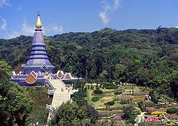
 Napamaytanidol Chedi (Km 41)
Continuing north of the main summit road, turn left at km 41.8 over a bridge on a paved road which leads to a magnificent chedi completed in 1989. These temples were built to honor the 60th birthday of the King Bhumipol and Queen in 1987 and 1992 respectively.
Summit of Doi Inthanon (Km 48)
The drive to the summit offers some fine views, especially during November and December, before the dry season haze has become well established. On your visit to the summit stupa containing the remains of King Inthawidhayanon, be sure to read the English translation on the back of the marble plaque nearby. Photographing any part of the radar station is forbidden, but visitors may take pictures freely of any other subject.
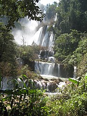
On the main road and opposite the summit Ranger Station is a sign in Thai marking a short, self-guided nature trail which descends to a sphagnum bog in a small karst depression. The bog area, which displays the red blossomed Rhododendron delavayi, comes nearest to a true montane forest formation and is a good location for bird-watching. If you continue around the bog and down a short distance, you will reach a memorial shrine marking the site of a helicopter crash which occurred in the mid-seventies and killed the first superintendent of this park. Mae Ya Waterfall (14 km from Chom Thong)
Thought to be the highest in Thailand and is well worth the extra effort to get there. Park officials estimate that the Mae Ya River plunges more than 250 meters at this point. It is a beautiful, fanning cascade, dropping down an ever-widening series of steps – without a doubt, a photographic favourite.
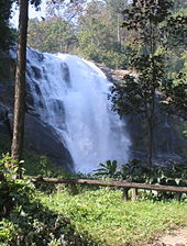
 Siriphum Waterfall
The Siriphum Waterfall (pronounced "see-ree-POOM") was an impressively tall waterfall that we noticed was accompanied by another thinner but just-as-tall companion waterfall. This was the third or uppermost of the major waterfalls on the way up to Doi Inthanon's peak (not counting the Sirithat Waterfall, which we didn't get to see), but we worked our way down from the top so it was our first waterfall stop in the park.
According the Thailand Tourism, the name of this falls came from a combination of Queen Sirikit and King Bhumipol. Thus, we also noticed some signs indicating this waterfall was referred to as Namtok Siribhum as opposed to Namtok Siriphum.
Sources, Images: http://en.wikipedia.org/wiki/Doi_Inthanon_National_Park,
http://www.chiangmai-chiangrai.com/doi_inthanon_park.html

 Thi Lor Sue waterfall is one main reason people travel to Umphang. It is the largest waterfall of Thailand, containing many smaller drops combined together for a magnificent view. Its height is about 200 meters and total width is about 400 meters. It is most beautiful during rainy season from June to November because of the larger water flow. However during this period, the road access to the waterfall is closed for safety reason and some hiking is required. The peak season for tourism is in December and January where the water level is still high and the road to waterfall (25 km) is open for public. Only cars with four wheel drive can pass this steep and slippery road. An alternative way to reach the waterfall is by whitewater rafting downstream along the calm section of Klong River and then continue journey either on foot or by car for another about 12 km. Travelling this way, two waterfalls dropping into Klong River will be seen: Thi Lo Jo Waterfall (Thai: น้ำตกทีลอจ่อ), and Sai Rung Waterfall (Thai: น้ำตกสายรุ้ง). The name Thi Lo Sue, in Karen language, means giant waterfall or black waterfall.
 Thi Lor Jo or Falling Rain waterfall is approximately 3 km from Umphang. The waterfall is divided into 2 tiers. The upper falls are located on a high cliff and the tier is narrow whereas the lower falls are part of the stream of the Klong River, falling like rain fall. It is possible to travel all year-round. It is only recently that Thi Lo Le Waterfall (Thai: น้ำตกทีลอเล) is promoted as an attraction for those who prefer adventure. It is a waterfall dropping directly into Klong River located deep in Thungyai Naresuan Wildlife Sanctuary with no road access. Only traveling with tour companies is possible. The journey to the waterfall typically involves white water rafting along Klong River of about 40 km through rapids of Class 4 or 5 while the journey back is usually by riding elephants. The trip takes 2 or 3 days.
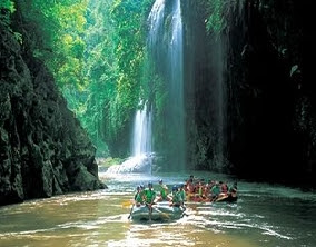

 There are also large rocks known a Kaeng Khonmong that are divided into 3 parts. There will be a wide river basin that has a large sandy bank. Continuing on, there are known large rapids and the river flows continuously onto the month of Huai Kachochita also known as Elephant Running Creek. There is an island in front of this area, which is suitable for camping overnight. After this is Kaeng Kachochile. Passing this, there is a large open space where the water flows toward a cliff resembling a cave on the edge of the river. A large waterfall tumbles down and there are vines and other plants hanging onto the cliff side. Ferns adorn the top of the limestone cliff. This is Thi Lor Lay waterfall, the final destination on the rafting route.