Tuesday, January 17, 2012

Cappadocia - Turkey

Cappadocia (also Capadocia; Turkish Kapadokya, from Greek: Καππαδοκία / Kappadokía) is a historical region in Central Anatolia, largely in Nevşehir Province.

In the time of Herodotus, the Cappadocians were reported as occupying the whole region from Mount Taurus to the vicinity of the Euxine (Black Sea). Cappadocia, in this sense, was bounded in the south by the chain of the Taurus Mountains that separate it from Cilicia, to the east by the upper Euphrates and the Armenian Highland, to the north by Pontus, and to the west by Lycaonia and eastern Galatia.
The name was traditionally used in Christian sources throughout history and is still widely used as an international tourism concept to define a region of exceptional natural wonders, in particular characterized by fairy chimneys and a unique historical and cultural heritage. The term, as used in tourism, roughly corresponds to present-day Nevşehir Province.

Cappadocia lies in eastern Anatolia, in the center of what is now Turkey. The relief consists of a high plateau over 1000 m in altitude that is pierced by volcanic peaks, with Mount Erciyes (ancient Argaeus) near Kayseri (ancient Caesarea) being the tallest at 3916 m. The boundaries of historical Cappadocia are vague, particularly towards the west. To the south, the Taurus Mountains form the boundary with Cilicia and separate Cappadocia from the Mediterranean Sea. To the west, Cappadocia is bounded by the historical regions of Lycaonia to the southwest, and Galatia to the northwest. The Black Sea coastal ranges separate Cappadocia from Pontus and the Black Sea, while to the east Cappadocia is bounded by the upper Euphrates, before that river bends to the southeast to flow into Mesopotamia, and the Armenian Highland. This results in an area approximately 400 km (250 mi) east–west and 250 km (160 mi) north–south. Due to its inland location and high altitude, Cappadocia has a markedly continental climate, with hot dry summers and cold snowy winters. Rainfall is sparse and the region is largely semi-arid.

History
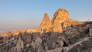
Cappadocia was known as Hatti in the late Bronze Age, and was the homeland of the Hittite power centred at Hattusa. After the fall of the Hittite Empire, with the decline of the Syro-Cappadocians (Mushki) after their defeat by the Lydian king Croesus in the 6th century, Cappadocia was ruled by a sort of feudal aristocracy, dwelling in strong castles and keeping the peasants in a servile condition, which later made them apt for foreign slavery. It was included in the third Persian satrapy in the division established by Darius, but continued to be governed by rulers of its own, none apparently supreme over the whole country and all more or less tributaries of the Great King.

Kingdom of Cappadocia
After bringing the Persian Empire to an end, Alexander the Great tried to rule the area through one of his military commanders. But Ariarathes, a Persian aristocrat, somehow became king of the Cappadocians. Ariarthes I (332—322 BC) was a successful ruler, and he extended the borders of the Cappadocian Kingdom as far as to the Black Sea. The kingdom of Cappadocia lived in peace until the death of Alexander. The previous empire was then divided into many parts, and Cappadocia fell to Eumenes. His claims were made good in 322 BC by the regent Perdiccas, who crucified Ariarathes; but in the dissensions which brought about Eumenes's death, the son of Ariarathes recovered his inheritance and left it to a line of successors, who mostly bore the name of the founder of the dynasty.

Under Ariarathes IV, Cappadocia came into relations with Rome, first as a foe espousing the cause of Antiochus the Great, then as an ally against Perseus of Macedon. The kings henceforward threw in their lot with the Republic as against the Seleucids, to whom they had been from time to time tributary. Ariarathes V marched with the Roman proconsul Publius Licinius Crassus Dives Mucianus against Aristonicus, a claimant to the throne of Pergamon, and their forces were annihilated (130 BC). The imbroglio which followed his death ultimately led to interference by the rising power of Pontus and the intrigues and wars which ended in the failure of the dynasty.

Roman and Byzantine province
The Cappadocians, supported by Rome against Mithridates VI of Pontus, elected a native lord, Ariobarzanes, to succeed (93 BC); but in the same year Armenian troops under Tigranes the Great entered Cappadocia, dethroned king Ariobarzanes and crowned Gordios as the new client-king of Cappadocia, thus creating a buffer zone against the encroaching Romans. It was not until Rome had deposed the Pontic and Armenian kings that the rule of Ariobarzanes was established (63 BC). In the civil wars Cappadocia was first for Pompey, then for Caesar, then for Antony, and finally, Octavian. The Ariobarzanes dynasty came to an end and a certain Archelaus reigned in its stead, by favour first of Antony and then of Octavian, and maintained tributary independence until AD 17, when the emperor Tiberius, on Archelaus' death in disgrace, reduced Cappadocia at last to a Roman province.

Cappadocia contains several underground cities (Kaymaklı Underground City), largely used by early Christians as hiding places before they became an accepted religion. The Cappadocian Fathers of the 4th century were integral to much of early Christian philosophy. It also produced, among other people, another Patriarch of Constantinople, John of Cappadocia, who held office 517—520. For most of the Byzantine era it remained relatively undisturbed by the conflicts in the area with the Sassanid Empire, but was a vital frontier zone later against the Muslim conquests. From the 7th century, Cappadocia was divided between the Anatolic and Armeniac themes. In the 9th–11th centuries, the region comprised the themes of Charsianon and Cappadocia.

Cappadocia shared an always-changing relationship with neighbouring Armenia, by that time a region of the Empire. The Arab historian Abu Al Faraj asserts the following about Armenian settlers in Sivas, during the 10th century: "Sivas, in Cappadocia, was dominated by the Armenians and their numbers became so many that they became vital members of the imperial armies. These Armenians were used as watch-posts in strong fortresses, taken from the Arabs. They distinguished themselves as experienced infantry soldiers in the imperial army and were constantly fighting with outstanding courage and success by the side of the Romans in other words Byzantine". As a result of the Byzantine military campaigns and the Seljuk invasion of Armenia, the Armenians spread into Cappadocia and eastward from Cilicia into the mountainous areas of northern Syria and Mesopotamia, and the Armenian Kingdom of Cilicia was eventually formed. This immigration was increased further after the decline of the local imperial power and the establishment of the Crusader States following the Fourth Crusade. To the crusaders, Cappadocia was "terra Hermeniorum," the land of the Armenians, due to the large number of Armenians settled there.

Turkish Cappadocia
Following the Battle of Manzikert in 1071, various Turkish clans under the leadership of the Seljuks began settling in Anatolia. With the rise of Turkish power in Anatolia, Cappadocia slowly became a tributary to the Turkish states that were established to the east and to the west, and some of the population converted to Islam. By the end of the early 12th century, Anatolian Seljuks had established their sole dominance over the region. With the decline and the fall of the Konya-based Seljuks in the second half of the 13th century, they were gradually replaced by the Karaman-based Beylik of Karaman, who themselves were gradually succeeded by the Ottoman Empire over the course of the 15th century. Cappadocia remained part of the Ottoman Empire for the centuries to come, and remains now part of the modern state of Turkey. A fundamental change occurred in between when a new urban center, Nevşehir, was founded in the early 18th century by a grand vizier who was a native of the locality (Nevşehirli Damat İbrahim Pasha), to serve as regional capital, a role the city continues to assume to this day.

In the meantime many former Cappadocians had shifted to a Turkish dialect (written in Greek alphabet, Karamanlıca), and where the Greek language was maintained (Sille, villages near Kayseri, Pharasa town and other nearby villages), it became heavily influenced by the surrounding Turkish. This dialect of Greek is known as Cappadocian Greek. Following the 1923 population exchange between Greece and Turkey, the language is now only spoken by a handful of the former population's descendants in modern Greece.

Modern tourism
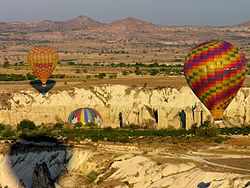
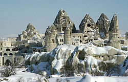
The area is a popular tourist destination, as it has many areas with unique geological, historic and cultural features.

The region is located southwest of the major city Kayseri, which has airline and railroad (railway) service to Ankara and Istanbul.

Sedimentary rocks formed in lakes and streams and ignimbrite deposits erupted from ancient volcanoes approximately 9 to 3 million years ago, during the late Miocene to Pliocene epochs, underlie the Cappadocia region. The rocks of Cappadocia near Göreme eroded into hundreds of spectacular pillars and minaret-like forms. The volcanic deposits are soft rocks that the people of the villages at the heart of the Cappadocia Region carved out to form houses, churches, and monasteries. Göreme became a monastic center in 300—1200 AD.

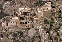
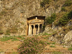
The first period of settlement in Göreme goes back to the Roman period. The Yusuf Koç, Ortahane, Durmus Kadir, and Bezirhane churches in Göreme, houses and churches carved into rocks in the Uzundere, Bağıldere, and Zemi Valleys all illustrate history and can be seen today. The Göreme Open Air Museum is the most visited site of the monastic communities in Cappadocia and is one of the most famous sites in central Turkey. The complex contains more than 30 carved-from-rock churches and chapels; some of them have superb frescoes inside, dating from the 9th century to the 11th century.

Mesothelioma
In 1975 a study of three small villages in central Cappadocia - Tuzköy, Karain and Sarıhıdır - found that peritoneal mesothelioma was causing 50% of all deaths. Initially, this was attributed to erionite, a zeolite mineral with similar properties to asbestos, but detailed epidemiological investigation demonstrated that the substance causes the disease mostly in families with a genetic predisposition to mineral fiber carcinogenesis. The studies are being extended to other parts of the region.


Source: http://en.wikipedia.org/wiki/Cappadocia
Images: http://commons.wikimedia.org/wiki/Category:Cappadocia

Hierapolis - Turkey

Hierapolis (Greek: εράπολις 'holy city') was the ancient Greco-Roman city which sat on top of hot springs located in south western Turkey near Denizli.

Hierapolis is a UNESCO World Heritage Site. The hot springs there have been used as a spa since the 2nd century BCE, and people came to soothe their ailments, with many of them retiring or dying here. The large necropolis is filled with sarcophagi, including the Sarcophagus of Marcus Aurelius Ammianos.

The great baths were constructed with huge stone blocks without the use of cement, and consisted of various closed or open sections linked together. There are deep niches in the inner section of the bath, library, gymnasium and other closed or open locations. The complex, which was constructed in the 2nd century BCE, constitutes a good example of vault type architecture. The complex is now an archaeological museum. Hierapolis is located adjacent to Pamukkale.

History
There are only a few historical facts known about the origin of the city. No traces of the presence of Hittites or Persians have been found. The Phrygians built a temple dedicated to Hieron, probably in the first half of the 3rd century BCE. This temple would later form the centre of Hierapolis. It was already used by the citizens of the nearby town Laodiceia, a city built by Antiochus II Theos in 261-253 BCE.

Hierapolis was founded as a thermal spa early in the 2nd century BCE and given by the Romans to Eumenes II, king of Pergamon in 190 BCE. The city was named after the existing temple, or possibly to honour Hiera, wife of Telephus — son of Heracles by a Mysian princess Auge - the mythical founder of the Attalid dynasty. The city was expanded with proceeds from the booty from the Battle of Magnesia in 190 BCE, where Antiochus the Great was defeated by Eumenes II, who had sided with the Romans. Thus Hierapolis became part of the Pergamon kingdom.

Hierapolis became a healing centre where doctors used the hot thermal springs as a treatment for their patients. The city began issuing bronze coins in the 2nd century BCE. These coins give the name Hieropolis (town of the temple Hieron). This name eventually changed into Hierapolis (Holy city).

Hierapolis was first excavated by the German archaeologist Carl Humann (1839–1896) during the months June to July 1887. His excavation notes were published in his 1889 book Altertümer von Hierapolis. His excavations were rather general and included a number of drilling holes. He would gain fame for his discovery in Pergamon of the Pergamon Altar which was reconstructed in the Pergamon Museum in Berlin.

Excavations began in earnest in 1957 when Italian scientists, led by Paolo Verzone, began working on the site. These studies continued into 2008 when a restoration of the site began. For example, large columns along the main street near the gate named after Domitian, that had been toppled by earthquakes, were erected again. A number of houses from the Byzantine period were unearthed, including an 11th century courtyard house.

Many statues and friezes were transported to museums in London, Berlin and Rome. In 1970, the Hierapolis Museum was built on the site of the former Roman baths.

After the large white limestone formations of the hot springs became famous again in the 20th century, it was turned into a tourist attraction named Cotton Castle (Pamukkale). The ancient city was rediscovered by travelers, but also partially destroyed by hotels that were built there. The new buildings were removed in recent years; however the hot water pool of one hotel was retained, and, for a fee, it is possible to swim amongst ancient stone remains.

Significant structures
Theatre
The first theatre was constructed to the northeast above the northern gate, when the ancient city was destroyed by earthquake in 17 CE.

After the earthquake of 60 CE and during the reign of emperor Titus Flavius Vespasianus, a new theatre was hollowed out of the slope of the hill further to the east, using the remains and the seats of the old theatre. There were alterations during the reign of emperors Hadrian and Septimius Severus. In 352 CE, it underwent a thorough restoration and was adapted for water shows.

The theatre is now under restoration. Many reliefs and statues, depicting mythological figures, have been excavated from the site.

Temple of Apollo
A temple was raised to Apollo Lairbenos, the principal god of Hierapolis, during the Hellenistic period (as can be seen on coins from Hierapolis). Apollo was linked to the ancient Anatolian sungod Lairbenos and the god of oracles Kareios. But ancient worship also centered on Cybele, Artemis, Pluto and Poseidon. Now only the foundations of the Hellenistic temple remain. The temple stood within a peribolos (15 by 20 metres (49 by 66 ft)) in Doric style. As the back of the temple was built against the hill, the peribolos was surrounded on three sides by marble Doric order columns. The new temple was reconstructed in the 3rd century in Roman fashion, but also by recycling the stone blocks from the older temple. It has a smaller area, and now only its marble floor remains.

Plutonium
Next to this temple, within the sacred area, is the oldest local sanctuary, called the Plutonium (in Greek Πλουτωνειον = "the place of Pluto") or Chronion (named after Cronus), or Charonion (named after Charon), a shrine to the god of the underworld. The Plutonium was described by several ancient writers including Strabo, Cassius Dio, and Damascius. It is a small cave, just large enough for one person to enter through a fenced entrance, beyond which stairs go down, and from which emerges suffocating carbon dioxide gas caused by underground geologic activity. Behind the 3 square metres (32 sq ft) roofed chamber is a deep cleft in the rock, through which fast flowing hot water passes releasing a sharp smelling gas. Because people died in the gas, people thought that the gas was sent by Pluto, god of the underworld.

During the early years of the town, castrated priests of Cybele descended into the Plutonium, crawled over the floor to pockets of oxygen or held their breath. Carbon dioxide is heavier than air and so tends to settle in hollows. They then came up to show that they were immune to the gas. People believed a miracle had happened and that therefore the priests were infused with superior powers and had divine protection.

An enclosed area of 2,000 square metres (22,000 sq ft) stood in front of the entrance. It was covered by a thick layer of suffocating gas, killing everyone who dared to enter this area. The priests sold birds and other animals to the visitors, so that they could try out how deadly this enclosed area was. Visitors could (for a fee) ask questions of the oracle of Pluto. This provided a considerable source of income for the temple. The entrance to the Plutonium was closed off during the Christian times.

Nymphaeum
The Nymphaeum is located inside the sacred area, in front of the Apollo temple. It dates from the 2nd century CE. It was a shrine of the nymphs, a monumental fountain distributing water to the houses of the city via an ingenious network of pipes. The Nymphaeum was repaired in the 5th century CE during the Byzantine era. The retaining wall was built with elements from the peribolos of the Apollonian temple. By doing so, the early Christians cut off the view of the pagan temple. The Byzantine gate was constructed in the 6th century CE.

Now only the back wall and the two side walls remain. The walls and the niches in the walls were decorated with statues. The Italian archaeological team has excavated two statues of priestesses, which now on display at the local museum.

The Nymphaeum has a U-shaped plan and sits on the continuation of the main colonnaded road. The stone pavement columns and other architectural remains mark a great part of the colonnaded road which ran through in a north-south direction. It has statues and shops around it, underneath which passed canals. The road had a base covered with stone blocks, now under the pool of the Private Administration. There are two huge doors which were constructed at the end of the 1st century CE which were left outside the city walls.

Necropolis
Following the main colonnaded road, and passing the Thermae extra muros, an extensive necropolis extends for over two kilometers on either side of the old road to Tripolis (Phrygia) and Sardis. The necropolis extends from the northern to the eastern and southern sections of the old city. Most of the tombs have been excavated. This necropolis is one of the best preserved in Turkey. Most of about the 1200 tombs were constructed with local varieties of limestone. The extent of this necropolis attests again to the importance Hierapolis had in the Antiquity.

Most tombs date from the late Hellenic period, but there are also a considerable number from the Roman period, and the early Christian period. People who came for medical treatment to Hierapolis in ancient times and the native people of the city buried their dead in tombs of several types according to their traditions and reflecting the social-economic status of the people.

Martyrium
The St. Philip Martyrium was named after the Christian apostle Philip and stands on top of the hill outside the northeastern section of the city walls. It dates from the 5th century CE. It was said that St. Philip was buried in the center of the building, and though his tomb has recently been unearthed, the exact location has not yet been verified. The Martyrium burned down at the end of the 5th or early 6th century CE, as attested to by fire marks on the columns. Philip is said to have been martyred in Hierapolis by being crucified upside-down, or by being hung upside down by his ankles from a tree.

In 2011 it was announced that Philip's gravesite may have been discovered about 40 metres (130 ft) from the Martyrium.


Source: http://en.wikipedia.org/wiki/Hierapolis
Images: http://commons.wikimedia.org/wiki/Category:Hierapolis

Thursday, January 5, 2012

Lycia - Turkey

Lycia (Lycian: Trm̃mis; Greek: Λυκία) was a region in Anatolia in what are now the provinces of Antalya and Muğla on the southern coast of Turkey. It was a federation of ancient cities in the region and later a province of the Roman Empire. The Lycian League founded in 168 BC was an early federation with democratic principles; these later influenced the United States Constitution.

The borders of Lycia varied over time but at its center was the Teke peninsula in south-western Turkey. It was bounded by Caria to the west and northwest, Pamphylia to the east, and Pisidia to the northeast. The region is mountainous and densely forested region with few large valleys. The mountains are the westernmost part of the Taurus mountains in particular the Akdağ and Beydağı mountains whose peaks can exceed 3000 meters. Inland is the Elmalı basin. The major rivers are the Eşen Çay (ancient Xanthos river), Demre Çay (ancient Myros river), Arykandos, and Alakir Çay. The area is known for steep gorges and underground rivers.

In modern Turkey the region is split between Antalya (on the east) and Muğla (on the west) provinces. The major city is Fethiye built on ancient Telmessos. Well known towns include Kalkan, Kaş, and Demre (ancient Myra). Inland Elmalı is fairly important. Turkey's first waymarked long-distance footpath, the Lycian Way, follows part of the coast of the region.

The principal cities of ancient Lycia were Xanthos, Patara, Myra, Pinara, Tlos and Olympos (each entitled to three votes in the Lycian League) and Phaselis. Cities such as Telmessos and Krya were sometimes listed by Classical authors as Carian and sometimes as Lycian.

Ancient names can sometimes be difficult to match with modern features: the Cragus and Anticragus mountains on the west side of the Xanthos river seem to include modern Babadağ.

Features and sights of interest
Although the 2nd-century AD dialogue, Erōtes, found the cities of Lycia "interesting more for their history than for their monuments, since they have retained none of their former splendor," many relics of the Lycians remain visible today. These relics include the distinctive rock-cut tombs in the sides of cliffs. The British Museum in London has one of the best collections of Lycian artifacts. Letoon, an important center in Hellenic times of worship for the goddess Leto and her twin children, Apollo and Artemis, and nearby Xanthos, ancient capital of Lycia, constitute a UNESCO World Heritage site.

The eponymous inhabitants of Lycia, the Lycians, spoke an Indo-European language, belonging to the Anatolian branch. The closest language to the Lycian language is the Luwian language, which was spoken in Anatolia during the 2nd and the early 1st millennia BC; Lycian may even be one of Luwian's direct descendants.
History
Bronze age
Ancient Egyptian records describe the Lycians as allies of the Hittites. Lycia may have been a member state of the Assuwa league of ca. 1250 BC, appearing as 'Lukka or Luqqa. After the collapse of the Hittite Empire, Lycia emerged as an independent "Neo-Hittite" kingdom. According to Herodotus, Lycia was named after Lycus, the son of Pandion II of Athens. The region was never unified into a single territory in antiquity, but remained a tightly-knit confederation of fiercely independent city-states.

Lycia was frequently mentioned by Homer as an ally of Troy. In Homer's Iliad, the Lycian contingent was said to have been led by two esteemed warriors: Sarpedon (son of Zeus and Laodamia) and Glaucus (son of Hippolochus). Elsewhere in Greek mythology, the Lycian kingdom was said to have been ruled by another Sarpedon, a Cretan exile and brother of the king Minos; Sarpedon's followers were called Termilae, and they founded a dynasty after their conquest of a people called the Milyans. As with the founding of Miletus, this mythical story implies a Cretan connection to the settlement of Asia Minor. Lycia appears elsewhere in Greek myth, such as in the story of Bellerophon, who eventually succeeded to the throne of the Lycian king Iobates (or Amphianax).

Classical period
Lycia came under the control of the Persian Empire in 546 BC when Harpagus of Media, a general in the service of Cyrus conquered Asia Minor. Harpagus's descendants ruled Lycia until 468 BC when Athens wrested control away. Following the ousting of the Persians, as Athens and Sparta fought the Peloponnesian wars, the majority of Lycian cities defaulted from the Delian League, with the exception of Telmessos and Phaselis.

In 429 BC, Athens sent an expedition against Lycia to try to force it to rejoin the league. This failed when Lycia's leader Gergis of Xanthos defeated General Melasander. The Lycians once again fell under Persian domination and by 412 BC, Lycia is documented as fighting on the winning side of Persia. The Persian satraps were re-installed, but (as the coinage of the time attests) they allowed local dynasts the freedom to rule. Persia held Lycia until it was conquered by Alexander III (the Great) of Macedon during 334–333 BC.

Hellenistic period
After the death of Alexander the Great in 324 BC, his generals fought amongst themselves over the succession. Lycia fell into the hands of the general Antigonus by 304 BC. In 301 BC Antigonus was killed by an alliance of the other successors of Alexander, and Lycia became a part of the kingdom of Lysimachus, who ruled until he was killed in battle in 281 BC. By 240 BC Lycia was part of the Ptolemaic Kingdom, centred on Egypt, and remained in their control through 200 BC. It had apparently come under Seleucid control by 190 BC, when the Seleucids' defeat in the Battle of Magnesia resulted in Lycia being awarded to Rhodes in the Peace of Apamea in 188 BC. It was then granted independence by Rome in 168 BC (see Lycian League below) and remained so until becoming a Roman province in 43 AD.

Lycian League
The Lycian League (Itlehi Trm̃mili) first came together around 205 BC and was formally established in 168 BC under democratic principles. It comprised some 23 known city-states as members. Lycia, which had been under Rhodian control since the Peace of Apamea in 188 BC, was granted independence by the Roman Republic at the conclusion of the Third Macedonian War. These city states joined together in a federal-style government that shared political resources against larger nations. A “Lyciarch” was elected by a senate that convened every autumn at a different city, where each member sent one, two or three representatives, depending on the city's size, to the senate, or Bouleuterion, as it was called.

The major cities of the League included Xanthos, Patara, Pinara, Olympos, Myra, and Tlos, with Patara as the capital. Phaselis joined the League at a later time. The league continued to function after Lycia became a Roman province in 46 AD. Lycia ceased being a federation in the 4th century AD, when it was taken over by the Byzantine Empire.

Roman period
In 43AD, the emperor Claudius annexed it to the Roman Empire as a province and by the time of Vespasian, it was united with Pamphylia as a Roman province. The heir of Augustus, Gaius Caesar, was killed there in 4 AD.

Byzantine era: It subsequently was a part of the Byzantine Empire.

Turkish era: It was incorporated into the Ottoman (Turkish) Empire and eventually became part of Turkey. A substantial Christian community of Greeks lived in Lycia until the 1920s when they were forced to migrate to Greece after the Population exchange between Greece and Turkey following the Greco-Turkish War in the early 20th century. The abandoned Greek villages in the region are a striking reminder of this exodus. Abandoned Greek houses can still be seen at in the towns of Demre, Kalkan, Kas and Kaya which is a Greek ghost town. A small population of Turkish farmers moved into the region when the Lycian Greeks migrated to Greece. The region is now one of the key centres of domestic and foreign tourism in Turkey.


Source: http://en.wikipedia.org/wiki/Lycia
Images: http://commons.wikimedia.org/wiki/Category:Lycia

Wednesday, January 4, 2012

Pamukkale - Turkey

Pamukkale, meaning "cotton castle" in Turkish, is a natural site in Denizli Province in southwestern Turkey. The city contains hot springs and travertines, terraces of carbonate minerals left by the flowing water. It is located in Turkey's Inner Aegean region, in the River Menderes valley, which has a temperate climate for most of the year.

The ancient Greco-Roman and Byzantine city of Hierapolis was built on top of the white "castle" which is in total about 2,700 metres (8,860 ft) long, 600 m (1,970 ft) wide and 160 m (525 ft) high. It can be seen from the hills on the opposite side of the valley in the town of Denizli, 20 km away.

Tourism is and has been a major industry. People have bathed in its pools for thousands of years. As recently as the mid-20th century, hotels were built over the ruins of Heropolis, causing considerable damage. An approach road was built from the valley over the terraces, and motor bikes were allowed to go up and down the slopes. When the area was declared a World Heritage Site, the hotels were demolished and the road removed and replaced with artificial pools. Wearing shoes in the water is prohibited to protect the deposits.

Geology
Pamukkale's terraces are made of travertine, a sedimentary rock deposited by water from the hot springs.

In this area, there are 17 hot water springs in which the temperature ranges from 35 °C (95 °F) to 100 °C (212 °F). The water that emerges from the spring is transported 320 metres (1,050 ft) to the head of the travertine terraces and deposits calcium carbonate on a section 60 to 70 metres (200 to 230 ft) long covering an expanse of 240 metres (790 ft) to 300 metres (980 ft). When the water, supersaturated with calcium carbonate, reaches the surface, carbon dioxide degasses from it, and calcium carbonate is deposited. The depositing continues until the carbon dioxide in the water balances the carbon dioxide in the air. Calcium carbonate is deposited by the water as a soft jelly, but this eventually hardens into travertine.

This reaction is affected by the weather conditions, ambient temperature, and the flow duration. Precipitation continues until the carbon dioxide in the thermal water reaches equilibrium with the carbon dioxide in the atmosphere. Measurements made at the source of the springs find atmospheric levels of 725 mg/l carbon dioxide, by the time this water flows across the travertines, this figure falls to 145 mg/l. Likewise calcium carbonate falls from 1200 mg/l to 400 mg/l and calcium 576.8 mg/l to 376.6 mg/l. From these results it is calculated that 499.9 mg of CaCO3 is deposited on the travertine for every liter of water. This means that for a flow rate of 1 ı/s of water 43,191 grams are deposited daily. The average density of a travertine is 1.48 g/cm3 implying a deposit of 29.2 dm3. Given that the average flow of the water is 465.2 l/s this implies that it can whiten 13,584 square metres (146,220 sq ft) a day, but in practice this area coverage is difficult to attain. These theoretical calculations indicate that up to 4.9 square kilometres (1.9 sq mi) it can be covered with a white deposit of 1 millimetre (0.039 in) thickness.

Archaeology: Museum
The former Roman Bath of the ancient city of Hierapolis has been used as the site of the Hierapolis Archaeology Museum since 1984.

In this museum, alongside historical artifacts from Hierapolis, there are also artifacts from Laodiceia, Colossae, Tripolis, Attuda and other towns of the Lycos (Çürüksu) valley. In addition to these, the museum has a large section devoted to artifacts found at Beycesultan Hüyük that includes some of the most beautiful examples of Bronze Age craft.

Artifacts from the Caria, Pisidia and Lydia regions are also on display in this museum. The museum’s exhibition space consists of three closed areas of the Hierapolis Bath and the open areas in the eastern side which are known to have been used as the library and gymnasium. The artifacts in open exhibition space are mostly marble and stone.

Tourist attraction
Pamukkale is a tourist attraction. It is recognized as a World Heritage Site together with Hierapolis. Hierapolis-Pamukkale was made a World Heritage Site in 1988.

The underground volcanic activity which causes the hot springs also forced carbon dioxide into a cave, which was called the Plutonium meaning place of the god, Pluto. This cave was used for religious purposes by priests of Cybele, who found ways to appear immune to the suffocating gas. Tadpoles can be found in the pools.


Source: http://en.wikipedia.org/wiki/Pamukkale
Images: http://commons.wikimedia.org/wiki/Category:Pamukkale

Selimiye Mosque - Turkey

The Selimiye Mosque (Turkish: Selimiye Camii) is an Ottoman mosque in the city of Edirne, Turkey. The mosque was commissioned by Sultan Selim II and was built by architect Mimar Sinan between 1569 and 1575. It was considered by Sinan to be his masterpiece and is one of the highest achievements of Islamic architecture.

Description
This grand mosque stands at the center of a külliye (complex of a hospital, school, library and/or baths around a mosque) which comprises a medrese (Islamic academy teaches both Islamic and scientific lessons), a dar-ül hadis (Al-Hadith school), a timekeeper's room and an arasta (row of shops). In this mosque Sinan employed an octagonal supporting system that is created through eight pillars incised in a square shell of walls. The four semi domes at the corners of the square behind the arches that spring from the pillars, are intermediary sections between the huge encompassing dome (31.25m diameter with spherical profile) and the walls.

While conventional mosques were limited by a segmented interior, Sinan's effort at Edirne was a structure that made it possible to see the mihrab from any location within the mosque. Surrounded by four tall minarets, the Mosque of Selim II has a grand dome atop it. Around the rest of the mosque were many additions: libraries, schools, hospices, baths, soup kitchens for the poor, markets, hospitals, and a cemetery. These annexes were aligned axially and grouped, if possible. In front of the mosque sits a rectangular court with an area equal to that of the mosque. The innovation however, comes not in the size of the building, but from the organization of its interior. The mihrab is pushed back into an apse-like alcove with a space with enough depth to allow for window illumination from three sides. This has the effect of making the tile panels of its lower walls sparkle with natural light. The amalgamation of the main hall forms a fused octagon with the dome-covered square. Formed by eight massive dome supports, the octagon is pierced by four half dome covered corners of the square. The beauty resulting from the conformity of geometric shapes engulfed in each other was the culmination of Sinan's life-long search for a unified interior space.

At the Bulgarian siege of Edirne in 1913, the dome of the mosque was hit by Bulgarian artillery. Due to the dome's extremely sturdy construction, the mosque survived the assault with only minor damage. On Atatürk's order, it has not been restored since then, to serve as a warning for future generations. Some damage can be seen on the image of the dome above, at and near the dark red calligraph to the immediate left of the central blue area.
The mosque was depicted on the reverse of the Turkish 10,000 lira banknotes of 1982-1995. The mosque, together with its külliye, was included on UNESCO's World Heritage List in 2011.


Source: http://en.wikipedia.org/wiki/Selimiye_Mosque
Images: http://commons.wikimedia.org/wiki/Category:Selimiye_Mosque

Followers