Monday, January 31, 2011

Wat Yai Chai Mongkhon - Ayutthaya

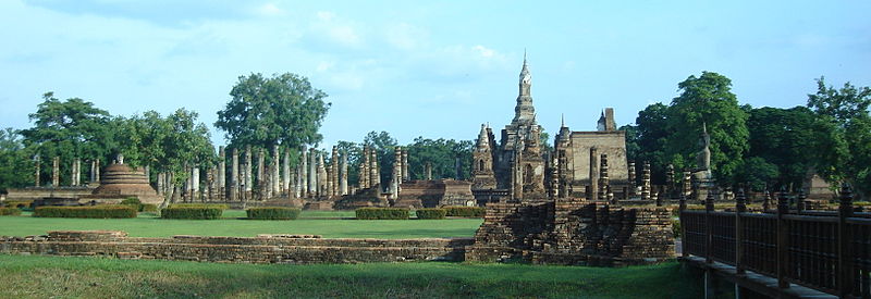
Wat Yai Chai Mongkhon (Thai: วัดใหญ่ชัยมงคล) or the “Great Monastery of Auspicious Victory” is located off the City Island in the southeastern area at present Tambon Phai Ling. In the past it bears other names as Wat Pa Kaeo, Wat Chao Phraya Thai and Wat Yai Chaya Mongkhon. A large Chedi of this Wat can be seen from a far distance. People come to play respect and many tourists are seen here especially during weekends.
The easiest way to reach this active monastery is by turning south at the roundabout chedi on Rojana Road (Wat Sam Plum) along road No 3059. The temple can be easily found at the eastern side of the road. Wat Yai Chai Mongkhon is situated in a part of the ancient city known as Ayodhya. It is widely believed that a Dvaravati (and Lopburi allied) settlement existed here before King U-Thong established Ayutthaya in 1351.
There are indications that the site was surrounded by a large moat in earlier times. The monastery was accessed before by Khlong (Pak) Khao San, which got its mouth at the new Pa Sak River. There are also traces of an ancient canal east and west of the temple; the latter ran, parallel with Khlong Khao San, also towards the Pa Sak River.
There are seemingly traces from an ancient barrier or water reservoir, close to the southwestern tip of the monastery. It could thus be that Wat Yai Chai Mongkhon has been built on a former important Khmer temple complex - taken also in account the large moat which represented for the Khmer, the oceans that surround the world.
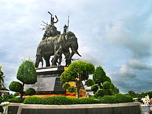
In 1592 King Naresuan (r. 1590-1605) defeated the Burmese Army at Nong Sarai by killing the Burmese Crown Prince in single-handed combat on elephant. In the battle the King and his brother King Ekathotsarot got separated from their army officers. On return to Ayutthaya the King wanted to punish to death his officers, but the Supreme Patriarch intervened and requested the punishment to be suspended; which King Naresuan granted. “The Royal Chronicles of Ayutthaya” although, state nothing about the construction of the great chedi. It is assumed that, on this occasion, King Naresuan ordered the restoration and enlargement of the temple and the principal chedi. The chedi was named Phra Chedi Chaya Mongkhon. Presumably this celebration gave rise to the temple’s new name, Wat Yai Chaya Mongkhon - The Great Temple of Auspicious Victory.
The Phraya of Tak (the later King Taksin) was promoted to Phraya Kamphaeng Phet by the Siamese King Suriyamin (Ekathat) and appointed as a brigade commander of a boat army that he had to constitute at this monastery in order to confront the Burmese in the open plains southeast of Ayutthaya end 1766. In 1767 the temple was sacked by the Burmese and the premises deserted. The monastery was re-established and officially recognized in 1957.
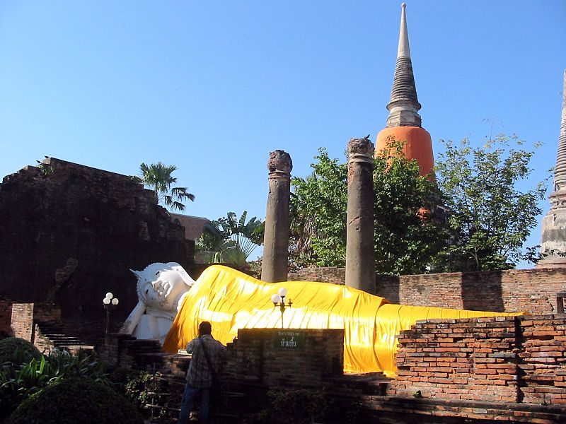
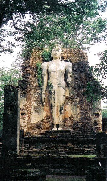
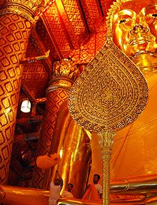
Viharn Phra Phuttha Saiyat or the Vihara of the Reclining Buddha was constructed during the reign of King Naresuan. The new image was remodeled in 1965 after the original got ruined by fortune hunters. The statue lies in a north-south position, with its head in southern direction and facing the east.
In 1979 the abbot, Phra Pawanarangsi, in coordination with the Fine Arts Department constructed a new ordination hall on the old remains, maintaining partly the ancient site, so that the original structure remains visible.
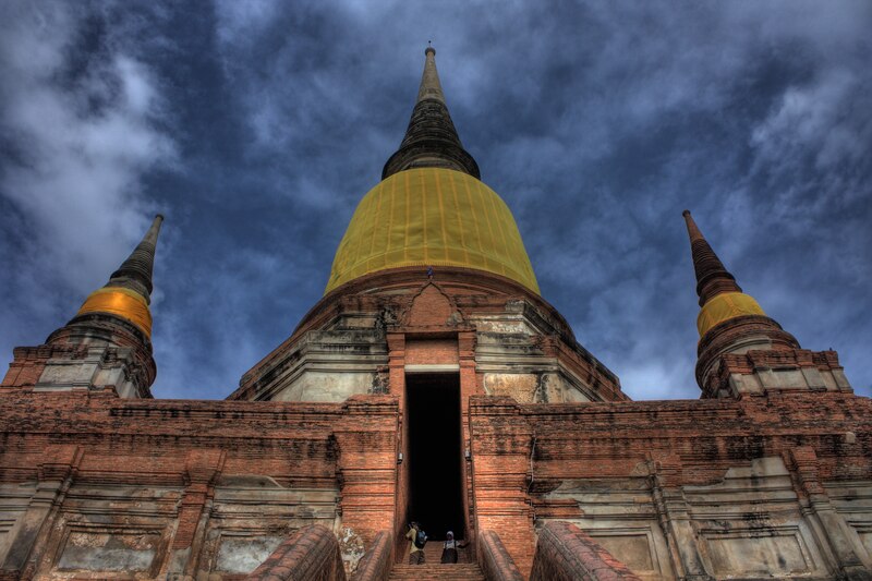
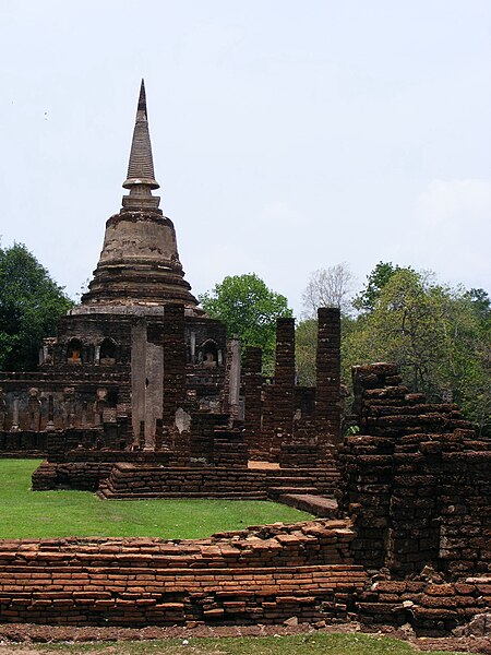
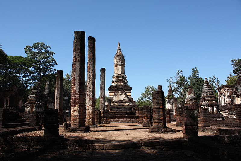
The chedi of Wat Yai Chai Monglhon is one of the landmarks of Ayutthaya, standing high, and visible to all, who approach the city from the east, at par with Chedi Phukhao Thong. The bell-shaped principal chedi stands on an elevated square base with smaller chedis at the corners. There is a second octagonal pedestal above the base to accommodate the bell-shaped body. Stairs lead up on the east side towards the first terrace, and continue inwards the dome. Inside the dome we can see the chamber where the relics were contained. Two mondops stand in the front, with their pyramidal upper structures collapsed, exposing the Buddha statues inside.
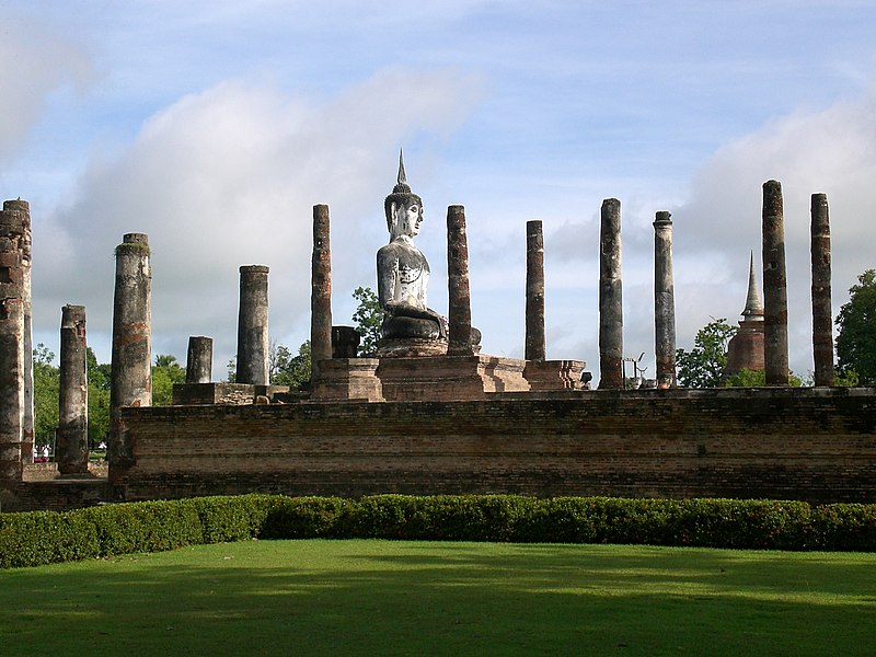
A rectangular gallery encircles the principal chedi. The gallery is enclosed by an outer wall, which along with the pillars inside, supported before the roof. Presently only the foundations of the pillars can be seen. The floor of the terrace is as usual one step higher than the court. Along the inner wall of the gallery are rows of (newly sculpted) Buddha images on decorated bases.
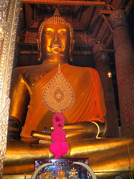
The ordination hall or ubosot lies east and in the front of the large chedi. The hall measures 16 m by 44 m and has been re-roofed to preserve it from further damage. Phra Phuttha Chaiya Mongkhon in the ordination hall is one of the most sacred Buddha images in Ayutthaya.
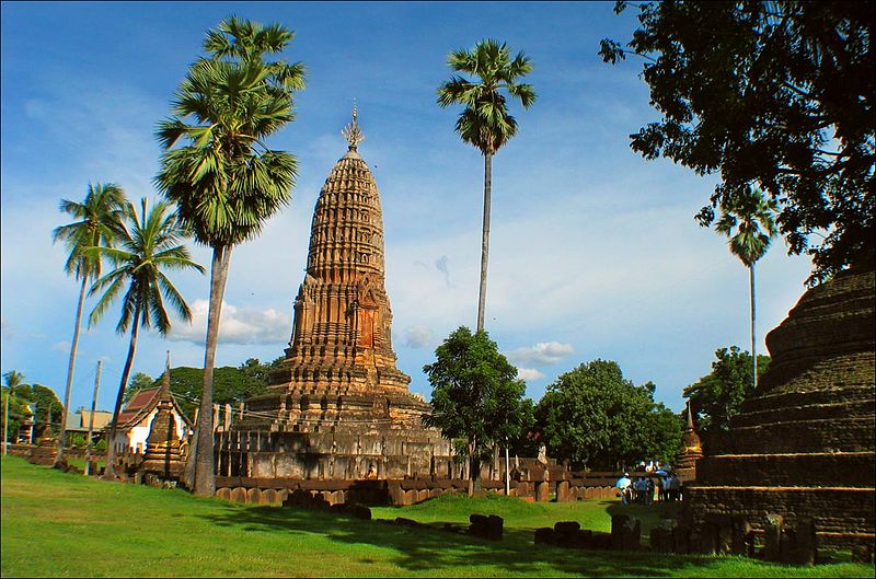
At the western side of the great chedi was a large vihara measuring 15 m by 39 m, nearly extending towards the outer boundary wall. In the area around the monastic structures we see more than twenty satellite chedis of various sizes which contain the ashes of former sponsors of this temple.
The area of the monastery has been extended towards the east. A viharn has been built to honor King Naresuan. The present entrance is situated between the monastery and the monk’s living quarters at the northern side.

Source: http://www.ayutthaya-history.com
Images: http://commons.wikimedia.org/wiki/Category:Wat_Yai_Chai_Mongkon

Wat Phanan Choeng - Ayutthaya

Wat Phanan Choeng (Thai: วัดพนัญเชิง) is located in the southeastern area at the confluence of the Chao Phraya and the Pa Sak Rivers, one of the most vibrant and oldest temples in Ayutthaya. This monastery has no record as to its date of construction or the person initiating its construction. It existed before Ayutthaya was founded as the capital.
Following the Luang Prasoet version of the Royal Chronicles of Ayutthaya, Phra Phanan Choeng was built in 1324, 26 years before King U-Thong founded Ayutthaya. At origin the Buddha image stood in the open.
The Buddha image - made of brick and mortar and covered with stucco - sits in the classic posture of Subduing Mara. It measures (approx.) 14 meters at the lap and 19 meters in height including the ornament above the head. Thai people call it “Luang Phor To” or “Great Reverend Father”, Chinese or Thais of Chinese origin call it “Sam Po Kong”. It is one of the largest, oldest, beautiful and revered Buddha images of Thailand.
When the Burmese took Ayutthaya in 1767, though an old temple, Wat Phanan Choeng has never been deserted by its followers. Continuous development has been made through time, as evidenced by the existing landscape and Thai architectural structures decorated by art motifs from different periods.
The monastery has four principal buildings in its sangkha area: an ordination hall, a vihara, the large vihara and a small Chinese building.
The ordination hall contains three Buddha images all in the posture of subduing Mara. Two images are assumed to have been built during the Sukhothai period around 1357. They were covered with stucco, lacquered and gilt, probably to hide their value from the Burmese invaders in 1767. In 1963 during a cleaning process, the stucco came off and the metal became visible. One image is in gold measuring a width of 145 cm and a height of 190 cm. The second one is made from an alloy of copper, silver and gold and measures at width 170 cm and at height is 228 cm. The third image in the middle of the pedestal is an Ayutthaya stucco image covered with gold (width 182 cm - height is 256 cm). The ubosot has beautiful mural paintings although from recent times.
The vihara located parallel and to the north side of the ordination hall has a Buddha image in the subduing Mara posture and also very nice Chinese mural paintings.
The large vihara behind the buildings above houses Luang Phor To. The large wooden entry doors are carved with beautiful floral designs, while the middle of the panels are decorated with deities and mythical animals, all in traditional Ayutthaya art. Inside the walls have hundreds of niches, each containing Buddha images and suggesting the principal image sitting in the middle of the Buddhist universe.
The large Buddha image has been repaired many times during Ayutthaya’s period of rule. King Mongkut (Rama IV) ordered a restoration in 1854 and named the statue Phra Buddha Trai Rattana Nayok. The temple and the Buddha image were damaged by fire on 21 December 1901. King Chulalongkorn (Rama V) ordered its restoration, what was finished the year after. The cheeks and the lower jaws of the image broke in pieces on 15 March 1928. In 1929 the Royal Institute had the necessary reparations made.

Source: http://www.ayutthaya-history.com
Images: http://commons.wikimedia.org/wiki/Category:Wat_Phanan_Choeng

Wat Phukhao Thong (Chedi Phukhao Thong) - Ayutthaya

Chedi Phukhao Thong (Thai: เจดีย์ภูเขาทอง) is a 50-metre chedi, or Buddhist tower, in the village of Phukhao Thong near Ayutthaya in central Thailand. Visitors can climb as far a landing halfway up the chedi, from which the surrounding rice fields and the town of Ayutthaya can be seen.
In 1569, having taken Ayutthaya, King Bayinnaung of Hongsawadi (now part of Myanmar) built a large chedi in the Mon style, next to the Buddhist temple of Wat Phukhao Thong, to commemorate his victory. Over the next two centuries the chedi fell into disrepair. In a restoration during the reign of King Boromakot (ruled 1733–1758) a new chedi in Thai style, having a square plan with indented corners, was built on the base of the ruin. The adjacent temple, founded by King Ramesuan in 1387, is still in use.
The history of this chedi reflects a tug-of-war struggle between Thailand and Burma. The temple was originally built by King Ramesuan during his second reign (1388-1395). The Burmese built a Mon-style tower over it in 1569 to celebrate its victory over Siam. Before this monument could be properly completed, Thailand retook Ayutthaya. King Naresuan (1590-1605) decided to add the crowning touch of a Thai-style chedi on top of the Mon-style base to celebrate his victory. However, some reports claim that this late construction was actually finished much later by King Prasat Thong (1629-1656). Other sources claim that it was King Boromakot (1733-1758) who added the final touch, but this was perhaps just a renovation. This temple was established near a major battle site. A Buddhist monk supervised the digging of a large canal (Klong Mahanak) nearby to defend the city from Burmese boats. This monk left priesthood to prepare Thai men for the siege, but his defensive moat proved unsuccessful in the end. The canal was named after this monk. Wat Phu Khao Thong was originally accessible by a series of canals, but unfortunately they have been covered over today.
This pyramidal, Mon-style, chedi is tied with Wat Yai Chai Mongkhon as the largest standing building in Ayutthaya. It really should be on everyone’s schedule as a site not to miss. Try to time your visit with the sunset or the sunrise, because the view can be breathtaking sometimes. There is a tunnel at the top of the chedi that leads to a hidden alter. If you’re lucky enough to find it open, don’t forget to crawl inside for a closer look. When you visit this massive chedi make sure to see the adjacent temple as well. There is an active temple built on the remains of an ancient ruin. The old pillars can still be seen. The active monastery has a nice Buddha footprint, which is covered with gold leaf. Underneath this Buddha footprint is a hidden alter. You must walk through the tiger protected staircase to enter it.
The statue of King Naresuan is built a few hundred meters away in front of the Chedi. The statue is quite impressive. On the four corners of the base, are images of the important weapons King Naresuan used during his life. At present, there are numerous colorfully painted images of fighting cocks all around the statue of the King.

Source: http://en.wikipedia.org/wiki/Chedi_Phukhao_Thong
Images: http://commons.wikimedia.org/wiki/Category:Wat_Phu_Khao_Thong_(Ayutthaya)

Thursday, January 27, 2011

Phra Chedi Sisuriyothai - Ayutthaya

Somdet Phra Sri Suriyothai (Thai: สมเด็จพระศรีสุริโยทัย) was a royal consort during the 16th century Ayutthaya period of Siam (now Thailand). She is famous for having given up her life in the defense of her husband, King Maha Chakkraphat in a battle during the Burmese-Siamese War of 1548.
Somdet Phra (สมเด็จพระ) is her queenly rank; Sri (ศรี), pronounced and often transcribed Si, is an honorific. Her given name Suriyothai (สุริโยทัย) means Dawn. It is a compound of Suriya, from Sanskrit surya SUN; plus Uthai from udaya RISING, a cognate of Aurora and Ushas.
Suriyothai was queen during the early part of the reign of King Maha Chakkraphat (2091 to 2106 Buddhist Era, with another reign from 2111 to 2112 B.E.). In 1548 AD, barely six months into King Maha Chakkraphat's reign, the King of Burma invaded Siam with the intent of sacking the main capital, Ayutthaya.
As was the custom at the time, King Maha Chakkraphat led his troops in the defense of the city from atop his war elephant. Even though women were not permitted to take part in battle, Queen Suriyothai was so concerned for her husband that she disguised herself as a man and rode into battle on her own elephant.
During the battle with Burmese troops, King Maha Chakkraphat's elephant collapsed from wounds and he was in danger of being killed. Queen Suriyothai rode her elephant to protect her husband and was killed by a scythe.
A memorial chedi to Queen Suriyothai, Phra Chedi Sisuriyothai (Thai: เจดีย์พระศรีสุริโยทัย), was built by King Maha Chakkraphat in her honor. The white and gold coloured Chedi is located at Wat Suanluang Sopsawan at the banks of the Chao Phraya, southwest of the Wang Luang (Royal Palace). There is also a memorial park to her outside of Ayutthaya, featuring a large statue of the queen riding a war elephant. It’s of some interest as a proof of the honour that ancient Siamese society gave to woman. It was renovated in 1990, and during the renovations some antique objects were found such as a white rock crystal Buddha image in the posture of subduing Mara, a chedi replica, and a golden reliquary. These ancient objects were brought to be under the care of the Chao Sam Phraya National Museum.
In 2001, a Thai movie about her life, The Legend of Suriyothai, was released. The film was directed by M.C. Chatrichalerm Yukol of the Thai Royal Family and financed by Queen Sirikit.


Source: http://en.wikipedia.org/wiki/Sri_Suriyothai
Images: http://commons.wikimedia.org/wiki/Category:Ayutthaya_historical_park

Sunday, January 23, 2011

Sukhothai Historical Park - Sukhothai

The Historic Town of Sukhothai and Associated Historic Towns is a Unesco World Heritage site which consists of Sukhothai historical park, Kamphaeng Phet historical park and Sri Satchanalai historical park. These historical parks preserve the remains of the three main cities of the Sukhothai Kingdom which had flourished during the 13th and 14th century CE. The Sukhothai Kingdom is viewed as having been the first of the Thai kingdoms.
The Sukhothai Historical Park (Thai: อุทยานประวัติศาสตร์สุโขทัย) covers the ruins of Sukhothai, capital of the Sukhothai kingdom in the 13th and 14th centuries, in what is now the north of Thailand. It is located near the modern city of Sukhothai, capital of the province with the same name.
The city walls form a rectangle about 2 km east-west by 1.6 km north-south. There are 193 ruins on 70 square kilometers of land. There is a gate in the centre of each wall. Inside are the remains of the royal palace and twenty-six temples, the largest being Wat Mahathat. The park is maintained by the Fine Arts Department of Thailand with help from UNESCO, which has declared it a World Heritage Site. The park sees thousands of visitors each year, who marvel at the ancient Buddha figures, palace buildings and ruined temples. The park is easily toured by bicycle or even on foot.
The protection of the area was first announced in the Royal Gazette on June 6, 1962. In 1976 the restoration project was approved, and in July 1988 the park was officially opened. On December 12, 1991, it was declared a World Heritage Site as part of the Historic Town of Sukhothai and Associated Historic Towns together with the associated historic parks in Kamphaeng Phet and Sri Satchanalai.

History
Sukhothai was the first kingdom of Siam established some 800 years ago. The exact year is unknown but according to the Fine Arts Office it was between 1238 and 1257. Established in around 1238 to 1257, Sukhothai literally means “Dawn of Happiness”. Phokhun Si Intharathit was the founder of the Phra Ruang Dynasty, Sukhothai’s first Dynasty. For 120 years as the capital of Siam, Sukhothai was ruled by many kings. In this connection, the most dynamic monarch being King Ramkhamhaeng the Great, who created the Thai alphabet, laid the foundation for politics, monarchy, and religion, as well as, expanded its boundary of influence. Though the golden era of Sukhothai no longer exists, tourists should bear in mind that respect and admiration for the renowned ruined twin cities of Sukhothai and Sri Satchanalai is valued.
Sukhothai historical park covers a total area of 70 square kilometers. It comprises of hundreds of historic sites located both inside the old city wall and also spreading out beyond the wall within a radius of approximately 5 kilometers. It might possible to take several days, up to a week, to cover all historic temples, but for those who have limited time, then just visiting some of those among the top of the list of “must see sites” should be very rewarding.
 Arriving inside the historic town of Sukhothai, the first and most important site to see, which is never skipped by visitors, is Wat Mahathat temple. Being the heart of Sukhothai’s religious area, Wat Mahathat was built in accordance with the ancient Indian concept of Mandala by the first king of Sukhothai Kingdom, King Sri Indrathit. The large compound of this significant temple comprises of 200 chedis – with the main one in the center, surrounded by 8 mini chedis, and has the elegant shape of a “lotus bud” characterizing the authentic art originating from Sukhothai. The chedis with lotus bud shapes can also be found at Wat Tra Phang Ngoen (located inside the old town) and at a few other temples located outside the town’s wall.
The numerous amounts of chedis found in the historical park can be roughly categorized into three different styles.
The first style is of an authentic Sukhothai style known as the lotus bud shaped chedi, while the other two styles were influenced by foreign kingdoms; Khmer and Lanka.  Before the establishment of Sukhothai, the area was influenced by Khmer art and culture, of which the evidence is seen in many Hindu temples which have been transformed into Buddhist temples during Sukhothai period, but with a Khmer architectural style of the main stupa called “Prang” remaining unchanged. Another style of chedi is found in Sukhothai – this is the “bell shaped” chedi influenced by Lankan art and which later became the general style of Buddhist chedi throughout the kingdom.
Next to Wat Mahathat is Wat Chana Songkram previously known as Wat Ratchaburana, the ancient temple with a big presidential chedi of a rounded bell shape and many smaller chedis and vihara create a beautiful layout. Adjacent to the east of Wat Mahathat, there is another interesting ruin called Noen Prasat Phra Ruang which is, according to the assumption of King Rama VI, the remains of the base of the Sukhothai royal palace. However, after the excavation of the site by the Fine Arts Department in 1983, there was no evidence found to support that original assumption. It was more likely to have been a religious building or a pavilion, as it is now believed that the palace was actually made of wood and would have been situated somewhere else – according to the similar layout of Khmer palace in Angkor Thom.
Another temple inside the wall of the old city is Wat Tra Phang Ngoen, located to the west of Wat Mahathat. The most significant highlight of this temple is its main chedi, resembling a lotus bud with four niches to enshrine standing or walking Buddhist images, which is what makes the chedi of this temple different to other lotus bud chedis found elsewhere. A vihara and an uposatha(the ordination hall) in the middle of a reservoir also boasts some outstanding features and is another “must visit” of this ancient site.
Nearby a corner of the historical compound, located Wat Sasi which is one of the most important historical sites in the old town of Sukhothai. It was built elegantly in the middle of a large reservoir known as Tra Phang Tra Kuan and composed with the main bell-shaped chedi of Lankan style, a beautiful Buddha image enshired in front of the vihara, and the ubosot or ordination hall situated in the islet in the middle of a lake. Without doubt, Wat Sasi is one of the stunning viewpoints in the historical park.
Next historical place, Wat Sri Sawai, which was originally a hindu sanctuary, but was later transformed into a Buddhist temple with a vihara added in the frontal part of the three “prangs” (the ogival towers as seen in the Angkorian temple) originally built in traditional Lopburi style which was influenced by Khmer art. The main visible evidence that proves this place to be a former Hindu temple is a carved lintel depicting the reclining Vishnu on Ananta Naga (Anantasayana) found at this historical site.
In the outer areas of Sukhothai, Wat Phra Phai Luang, which is the second most important temple built before the foundation of the Sukhothai Kingdom and was also the center of the first settlement. The most interesting spot is the three prangs of Bayon, styled during the reign of the Khmer King Jayavarman VII.
A bit further on is the location of Wat Si Chum, the ancient monument which is a highlighted destination and also the symbol of Sukhothai’s tourism, well known for a huge “sitting-posture” Buddha image named “Phra Achana” which is carved in the attitude of subduing Mara, spanning an impressive width of 11.30 meters. Phra Achana is enshrined in the chapel hall, with its walls as thick as 3 meters. On one side of the wall is a recess where a stone inscription details the founding of the Sukhothai dynasty and on its ceiling it is decorated with more than 50 pictures carved into the stone, telling stories of former incarnations of Lord Buddha (Jataka) accompanied by captions for each picture written in the Sukhothai alphabet.
Another temple, Wat Saphan Hin, located on a small hilltop of 200 meters. So, to reach the upper yard of the sanctuary it takes a little bit more energy to follow the slate staircase, but the effort will be fully repaid with a great view of the plain and an “upright posture” Buddha image watching over the surrounding areas, standing tall at 12.5 meters.
If it is not so much cloudy, so you have a change to view the sunset behind Wat Mahathat. However the sky during the twilight, orange tints and rays of light bursting in between the clouds illuminated the chedis and images of Buddha, producing a breathtaking scene of this historically spiritual site. It will be an unforgettable dusk with a magical brilliance that briefly takes you back to the previous glory of the Sukhothai Kingdom.

Source: http://en.wikipedia.org/wiki/Sukhothai_historic_park
Images: http://commons.wikimedia.org/wiki/Category:Sukhothai_historical_park

Thursday, January 20, 2011

Sri Satchanalai Historical Park - Sukhothai

The Sri Satchanalai Historical Park (Thai: อุทยานประวัติศาสตร์ศรีสัชนาลัย) is a historical park in Si Satchanalai district, Sukhothai Province, northern Thailand.
The protection of the area was first announced in Volume 92, Part 112 of the Royal Gazette on August 2, 1961. In 1976 the restoration project was approved, and in July 1988 the park was officially opened. On December 12, 1991, it was declared a World Heritage site, together with the associated historic parks in Kamphaengphet and Sukhothai.
Images: http://commons.wikimedia.org/wiki/Category:Si_Satchanalai_historical_park
Sri Satchanalai Historical Park is just the perfect place for hiding away in some secret corner behind the bare bricks of ancient temples, or under the shade of huge trees – just relaxing and watching the sky role by. Located 68 km north of Sukhothai, Sri Satchanalai, previously known as Chaliang, possesses many significant historic monuments of the same era as Sukhothai.
Although there are fewer temples than in Sukhothai in the rampart of the city. You can sit – spending time contemplating the remains of Sukhothai’s long history that stretches back several centuries. It’s really amazing, whenever you think that those lumps of bricks and ancient constructions are still in existence and a touchable part of the past from hundreds of years ago.
From the main entrance, all visitors are usually mesmerised by the first highlight of Sri Satchanalai, Wat Chang Lom, located in the center of this historic town. The temple is acclaimed as being one of the most beautiful of its kind, because the main Sri Lankan style chedi is surrounded by 39 sculptures of elephants at its base. The sculptures of the elephants at Wat Chang Lom in  Sri Satchanalai are quite different from  those found at other temples, as they represent standing elephants which are all “larger than life”.
Just opposite to Wat Chang Lom, Wat Chedi Chet Thaeo is located with various styles of chedis in the beautiful calm setting of the temple. It is compared as being as significant as Wat Mahathat in Sukhothai Historical Park, built during the period of King Ramkhamhaeng. The presidential chedi is in the style of the beautiful lotus-bud shaped chedi, the actual name of the temple translates as “the temple with seven rows of chedi”, and is derived from its 33 subordinate chedis erected inside the wall, which are also quite famous for various styles of art such as Sri Lankan, Pagan and Srivijaya. The late Prince Damrongrajanuphap – an expert of Thai history – suggested that this temple might be the place where the cremated remains of the Sukhothai royal family were kept.
Within the nearby compound, there are a few other places worthy of being visited, such as Wat Suan Keao Utthayan Noi, Wat Suan Keao Utthayan Yai, and Wat Nang Phaya – with a vihara building made of laterite block and the exterior face of its walls decorated with highly elaborated stucco, showing different styles of art from the Ayutthaya period. The atmosphere of Wat Nang Phaya is quiet and peaceful, because it is located far from the main group of historic sites adjacent of the southern rampart.
There are some significant historical sites located outside of the old town of Sri Satchanalai, paying a visit to Wat Phra Sri Ratanamahathat first.
Wat Phra Sri Ratanamahathat, locally called Wat Phra Borommathat Muang Chaliang, is one of the most important temples – assumed by archeologists to have been founded during the pre-Sukhothai period. The temple is composed of a few major buildings, the most appealing of which is the presidential prang. The main shrine of the temple was built to cover an earlier stupa of the pre-Sukhothai period, constructed from blocks of laterite, which were in turn covered with lime plaster and red paint. The prang, as seen today by its architectural characteristics, can be identified as having been built during the early Ayutthaya period. Another rare masterpiece of  Thai historical art that still remains today and is only available at this temple, is a priceless column – its top is decorated with stucco and it also displays an image of Bodhisattva.
Back into the old town of Sri Satchanalai, visitors can go up hill where another two historical sites – Wat Khao Phanom Ploeng and Wat Khao Suwan Khiri are located. To reach the top, you can either take the staircase or drive up the paved road on the other side. It is a hill slope that can be climbed fairly easily by mountain bike. On the hill, you can go to Wat Khao Suwan Khiri to see its bell-shaped chedi and to the other important temple - Wat Khao Phanom Ploeng.

Kamphaeng Phet Historical Park - Kamphaeng Phet

Kamphaeng Phet Historical Park (Thai: อุทยานประวัติศาสตร์กำแพงเพชร) is an archeological site in Kamphaeng Phet, Thailand. Along with Sukhothai Historical Park and Si Satchanalai historical park, it is a part of the UNESCO World Heritage Site Historic Town of Sukhothai and Associated Historic Towns. Major features in the Kamphaeng Phet Historical Park include archaeological remains of ancient sites such as Mueang Chakangrao to the east of the Ping River, Mueang Nakhon Chum to the west and Mueang Trai Trueng some 18 km from the town to the southwest. Chakangrao, the ancient Kamphaeng Phet town, had the same town planning concept as the old Sukhothai and Sri Satchanalai, with separate zones for religious sites both within and outside of town limits.

Structures are usually large and made of laterite - which is a very unique material and rarely found elsewhere in Thailand. Most of them have been constructed in the genuine local style of Kamphaeng Phet , reflecting the craftsmanship and beliefs of the former ancestors into the present day.
Religious sites on the west bank of the Ping River at Nakhon Chum are built of bricks and of smaller size. City walls and old fortifications mark the boundary of the rectangular town area, measuring 300-700 metre wide and 2,200 metre long.
Almost all ancient buildings and monuments in the old town of Kamphaeng Phet were used as religious places for Theravada Buddhism (originating from Sri Lanka). According to many stone inscriptions from the Sukhothai period and some architectural and sculptural evidence, Kamphaeng Phet was found in the same period of Sukhothai during the late 15th century AD, or otherwise known as being after the reign of King Ramkhamhaeng.
Sights
Wat Phra Kaeo (วัดพระแก้ว) is a large royal temple in town centre near a site believed to have been a palace. The temple itself was used on important city events and had no monks in residence. Major features include the principal Chedi with lion-adorned base and a round Chedi with elephant-adorned base. There are also other Chedis of different bases and remains of several chapels. Its boundary is marked off by laterite walls. The layout of this temple is very rare to find, placing the reclining Buddha image in front of the two sitting Buddha images, and so it has become one of the most appealing tourism symbols of Kamphaeng Phet that definitely should be visited.
Second in size to Wat Phra Kaeo is Wat Phra That (วัดพระธาตุ). Here the principal Chedi is built of mixture of laterite and bricks with a 15-metre wide square base. The style is of Kamphaeng Phet architecture.
Sa Mon (สระมน) is the site of the palace located to the north of Wat Phra Kaeo with a square earthen wall almost touching the northern city wall. Surrounded the walls on three sides are moats with a pond in the middle. There are no standing structures remaining today.
Wat Phra Non (วัดพระนอน) is fenced in by laterite walls on four sides. At the front of the temple are a square-shaped pond, bathrooms and an ancient floating pavilion which is supported by a large laterite column. The entire column was cut out in one single piece from its source and measures 1.1 meters on each side and 6.4 meters in height, the largest such stone in the country. A lion sculpture and Sema stones (boundary stones) can still be discerned. The large Vihan which once housed the Reclining Buddha has crumbled entirely.
Wat Phra Si Iriyabot (วัดพระสี่อิริยาบถ) is located to the north of Wat Phra Non and have similar pond and bathroom facilities as its neighbour. Walls on the four sides are of laterite materials with an entrance also made of laterite. A Mondop structure houses Buddha statues in four postures-walking, sitting, standing and reclining. But only one big standing Buddha image on the south of the chapel remains until today, showing a harmonious mix of Sukhothai and Kamphaeng Phet art and architecture.

Wat Phra Sing (วัดพระสิงห์) is believed to have been constructed during both the Sukhothai and Ayutthaya periods. With laterite walls, it has a square-shaped principal Chedi with arches on four sides. In front of the Ubosot are ornamental lion and Naga figurines.
Wat Chang Rob (วัดช้างรอบ) is a large temple situated on a high hill. As its name suggests, Wat Chang Rob means “the temple surrounded by elephants”. Its main chedi of Ceylonese style is in the middle of the yard but its top part is broken down. The base is adorned with 68 half-elephants between which are Bhoti-shaped designs. There are also traces of demon and female dancers’ figures remaining.
Kamphaeng Phet Historical Park might not be one of the most major destinations for tourists, as it’s likely to be just another sleepy old town and it is does not seem so appealing to passersby. However, Kamphaeng Phet historical site – especially in the forest areas outside the old town is one of the places should be visited. Therefore, locals and foreigners should be alike to visit and support the maintenance of this truly beautiful historic site.

Source: http://en.wikipedia.org/wiki/Kamphaeng_Phet_historical_park
Images: http://commons.wikimedia.org/wiki/Category:Kamphaeng_Phet_historical_park

Tuesday, January 11, 2011

Vientiane - Laos

Vientiane (Lao: Wiang-jun; Thai: เวียงจันทน์ Wiang-chan; literally "City of Sandalwood") is the capital and largest city of Laos, situated in the Mekong river. Vientiane became the capital in 1563 due to fears of a Burmese invasion. During French rule, Vientiane was the administrative capital and due to economic growth in recent times, it has become the economic centre of Laos.
The estimated population of the city is 726,000 (2007) while the number of people living in the Vientiane metropolitan area (the entire Vientiane Prefecture and parts of Vientiane Province) is believed to be over 730,000. The city hosted for the first time the 25th Southeast Asian Games in December 2009 celebrating the 50 years of SEA Games.
Sri Sattanak, or Sisattanak  is a former name of Vientiane. It is often confused with Sri Sattanakanahut, the Pali name of Lan Xang, the Kingdom of the Million Elephants. Sisattanak now is the name of one of the five districts of the city Vientiane.
The name of the city is derived from Pali, the liturgical language of Theravada Buddhism. Its original meaning is "royal sandalwood grove" or "city of sandalwood", this tree being highly valued in classical India for its fragrance. In modern Lao, the meaning of Vientiane is ambiguous, and is often mistakenly believed to mean "city of the moon", because the words for 'moon (Chandra in Sanskrit)' and 'sandalwood (chandana in Sanskrit)' are written and pronounced identically as 'jan'. However, the name in Thai, เวียงจันทน์, retains the etymologically correct spelling, and clearly indicates "city of sandalwood" as the meaning. The romanized spelling "Vientiane" is of French origin, and reflects the difficulty the French had in pronouncing the hard "j" sound in the Lao word; a common English-based spelling is "Viangchan", or occasionally "Wiangchan".
History
The great Laotian epic, the Phra Lak Phra Lam, claims that Prince Thattaradtha founded the city when he left the legendary Lao kingdom of Muong Inthapatha Maha Nakhone because he was denied the throne in favor of his younger brother. Thattaradtha founded a city called Maha Thani Si Phan Phao on the western banks of the Mekong River; this city was told to have later become today's Udon Thani, Thailand. One day, a seven-headed Naga told Thattaradtha to start a new city on the eastern bank of the river opposite Maha Thani Si Phan Phao. The prince called this city Chanthabuly Si Sattanakhanahud; which was told to be the predecessor of modern Vientiane.
Contrary to the Phra Lak Phra Ram, most historians believe Vientiane was an early Khmer settlement centered around a Hindu temple, which the Pha That Luang would later replace. In the 11th and 12th centuries, the time when the Lao and Thai people are believed to have entered Southeast Asia from Southern China, the few remaining Khmers in the area were either killed, removed, or assimilated into the Lao civilization, which would soon overtake the area.
In 1354, when Fa Ngum founded the kingdom of Lan Xang, Vientiane became an important administrative city, even though it was not made the capital. King Setthathirath officially established it as the capital of Lan Xang in 1563, to avoid Burmese invasion. When Lan Xang fell apart in 1707, it became an independent Kingdom of Vientiane. In 1779, it was conquered by the Siamese general Phraya Chakri and made a vassal of Siam.
When King Anouvong raised an unsuccessful rebellion, it was obliterated by Siamese armies in 1827. The city was burned to the ground and was looted of nearly all Laotian artifacts including Buddha statues and people. Vientiane was in great disrepair when the French arrived, arrived to only find a depopulated region with even the great city of Vientiane disappearing into the forest. It eventually passed to French rule in 1893. It became the capital of the French protectorate of Laos in 1899. The French rebuilt the city and rebuilt or repaired Buddhist temples such as Pha That Luang, Haw Phra Kaew, and left many colonial buildings behind.
Vientiane was the host of the incident free 2009 Southeast Asian Games, with 18 disciplines being dropped from the previous games held in Thailand due to Laos' landlocked state and the lack of adequate facilities in Vientiane.
Vientiane is situated on a bend of the Mekong river, which forms the border with Thailand at this point. Vientiane features a tropical wet and dry climate (Koppen Aw) with a distinct monsoon season and a dry season. Vientiane’s dry season spans from November through March. April marks the onset of the monsoons which in Vientiane lasts about seven months. Vientiane tends to be hot and humid throughout the course of the year, though temperatures in the city tend to be somewhat cooler during the dry season than the wet season.
Sights
Although a small city still, the capital has many sites for tourist to see. The city contains many temples and Buddhist monument with Pha That Luang, a Buddhist stupa, one of the most famous in Laos. It is the most important national cultural monument and very popular amongst foreign tourist. The original was built in 1566 by King Setthathirath, and was restored in 1953. The golden stupa is 45 meters tall and is believed to contain a relic of the Lord Buddha.
Another site that is also popular amongst tourist is Wat Si Muang. The temple was built on the ruins of a Khmer Hindu shrine, the remains of which can be seen behind the ordination hall. It was built in 1563 and is believed to be guarded by the spirit of a local girl called “Si". Legend says that Nang Si, who was pregnant at the time, leapt to her death as a sacrifice, just as the pillar was being lowered into the hole. In front of the temple stands a statue of King Sisavang Vong.
The memorial monument, Patuxai, began construction in 1957 and completed in 1968, is perhaps the most prominent landmark in the city. While the arc de Triomphe in Paris inspired the architecture, the design incorporates typical Lao motifs including “Kinnari”, a mythical bird woman. Energetic visitors can climb to the top of the monument, which reveals an excellent panoramic view of the city.
Buddha Park was built in 1958 by Luang Pou Bounlua Soulilat and contains a collection of Buddhist and Hindu sculptures, scattered amongst gardens and trees. The park was built about 28 kilometers south of Vientiane at the edge of the Mekong River.
Vientiane is home to one of Laos' only bowling alleys (the other bowling alley being in Luang Prabang) and its only mosques. There are many upper-class hotels in Vientiane.
Other sites include:
  • Haw Phra Kaew, former temple, now museum and small shops
  • Lao National Museum
  • Talat Sao Morning Market
  • That Dam, large stupa
  • Wat Ong Teu Mahawihan, Buddhist monastery
  • Wat Si Saket, Buddhist wat
  • Wat Sok Pa Luang, Buddhist temple
Transportation
From Thailand: The First Thai-Lao Friendship Bridge, built in the 1990s, crosses the river 18 kilometers downstream of the city to Nong Khai in Thailand, and is the major crossing between the two countries. The bridge was built with provision for metre gauge rail services. Test trains began running and Thanaleng Railway Station on July 4, 2008, and the railway was formally inaugurated on March 5, 2009. Surveys are underway to continue to the line a further 12 km to Vientiane.
The official name of the bridge was changed in 2007 by the addition of "First", after the Second Friendship Bridge linking Mukdahan in Thailand with Savannakhet in Laos was opened early in 2007.
In October 2010, plans were announced for a 530km high-speed railway linking Vientiane to Xishuangbanna, in Yunnan province in China.
Within Laos: There are regular bus services connecting Vientiane Bus Station with the rest of the country.
To Thailand: Daily non stop direct bus services run between Vientiane and Nong Khai, Udon Thani and Khon Kaen.
By Air: Vientiane is served by the Wattay International Airport with international connections to other Asian countries. Lao Airlines has regular flights to several domestic destinations (several flights daily to Luang Prabang; a few flights weekly to other destinations).
Healthcare
The "Centre Medical de l’Ambassade de France" is available to the foreign community in Laos in April 2007. Also the Mahosot Hospital is an important hospital in treating and researching diseases and is in connection with the University of Oxford.

Source: http://en.wikipedia.org/wiki/Vientiane
Images: http://commons.wikimedia.org/wiki/Category:Vientiane

Followers