The Phi Phi Islands (Thai: หมู่เกาะพีพี) are located in Thailand, between the large island of Phuket and the western Andaman Sea coast of the mainland. The islands are administratively part of Krabi province. Ko Phi Phi Don ("ko" (Thai: เกาะ) meaning "island" in the Thai language) is the largest island of the group, and is the only island with permanent inhabitants, although the beaches of the second largest island, Ko Phi Phi Lee (or "Ko Phi Phi Leh"), are visited by many people as well. The rest of the islands in the group, including Bida Nok, Bida Noi, and Bamboo Island, are not much more than large limestone rocks jutting out of the sea.

Phi Phi Don was initially populated by Muslim fishermen during the late 1940s, and later became a coconut plantation. The Thai population of Phi Phi Don remains more than 80% Muslim. The actual population however, if counting laborers, especially from the north-east, from the mainland is much more Buddhist these days.
The islands came to worldwide prominence when Ko Phi Phi Leh was used as a location for the 2000 British-American film The Beach. This attracted criticism, with claims that the film company had damaged the island's environment, an accusation the film's makers contest. The film's release was attributed to an increase in tourism to the islands. Phi Phi Leh also houses the 'Viking Cave', from which there is a thriving bird's nest soup industry.
 Ko Phi Phi was devastated by the Indian Ocean Tsunami of December 2004, when nearly all of the island's infrastructure was destroyed. As of 2010 most, but not all, of this has been restored.
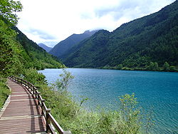
From archaeological discoveries, it is believed that the area was one of the oldest communities in Thailand dating back to the prehistoric period. It is believed that this province may have taken its name after the meaning of Krabi, which means sword. This may have stemmed from a legend that an ancient sword was unearthed prior to the city’s founding.
The name Phi Phi (pronounced ‘pee pee’) originates from Malay, the original name for the islands were ‘Pulao Pi ah Pi’. The name refers to the mangrove wood found there. They were incorporated into the national park in 1983. There are six islands in the group known as Phi Phi. They lie 50 km south-east of Phuket and are part of Hadnopparattara-Koh Phi Phi National Park which is home to an abundance of corals and marine life. There are limestone mountains with cliffs, caves and long white sandy beaches. The national park covers a total area of 242,437 Rai.
 Phi Phi Don and Phi Phi Le are the largest and most well-known islands. Phi Phi Don is 28 sqm: 8 km in length and 3.5 km wide. Phi Phi Le is 6.6 km. Koh Phi Phi comprises 6 islands, 2 of them are the main island – Phi Phi Don and Phi Phi Le. On Koh Phi Phi there are 2 villages and under administration of Ao Nang sub-district, Muang district, Krabi Province. The islands are surrounded by the Andaman Sea.
The islands feature beaches and clear water that have had their natural beauty protected by National Park status. Tourism on Ko Phi Phi, like the rest of Krabi province, has exploded only very recently. In the early 1990s only the most adventurous travelers visited the island, staying in only the most basic accommodation. Nowadays, however, the place has turned into one of the major destinations for visitors to Krabi. The is still significantly less developed than the nearby island of Phuket, or Ko Samui, on Thailand's opposite coast.
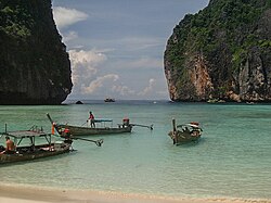
Ko Phi Phi is a popular place for diving and snorkeling, kayaking and other marine recreational activities.

Post-tsunami reconstruction
After the tsunami, approximately 70% of the buildings on the island had been destroyed. However, January 6, 2005, a former Dutch resident of Phi Phi, Emiel Kok, set up a voluntary organization, Help International Phi Phi. Hi Phi Phi recruited 68 Thai staff from the refugee camp, as well as transient backpacker volunteers (of whom more than 3,500 offered their assistance), and returned to the island to undertake clearing and rebuilding work. On February 18, 2005, a second organization, Phi Phi Dive Camp, was set up to remove the debris from the bays and coral reef, most of which was in Ton Sai Bay.
By the end of July 2005, 23,000 tonnes of debris had been removed from the island, of which 7,000 tonnes had been cleared by hand. "We try and do as much as possible by hand," said Kok, "that way we can search for passports and identification". The majority of buildings that were deemed fit for repair by government surveyors had been repaired, and three hundred businesses had been restored. Hi Phi Phi was nominated for a Time Magazine Heroes of Asia award.
 On October 31, 2005, Deputy Prime Minister Pinit Jarusombat proposed an upgrade to the hotels and restaurants on Phi Phi Don, and a limitation to the number of tourists visiting. "It'll help us preserve its environment," said Pinit. However, after consultation with residents and land-owners, many of whom opposed the plan, the Bangkok Post reported on February 17, 2006, that the proposals would not affect Phi Phi.
As of 6 December 2005, nearly 1,500 hotel rooms were open, and a tsunami early warning alarm system had been installed by the Thai government, with the help of volunteers.

Ko Phi Phi Don (Thai: เกาะพีพีดอน) is the largest of the Phi Phi Islands, in Thailand. It is the only island in the group with permanent inhabitants.
Like the other islands in the group, Ko Phi Phi Don is a non-volcanic island largely made of limestone. It is almost separated into two islands, but a strand of flat land connects them. On this strand lies the largest town on the island, as well as most of the resorts.
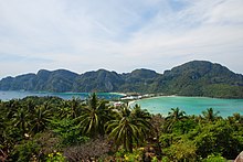 Ko Phi Phi Don is now squarely on the tourist map, and tourists from all over the world (especially Europe, Japan, and the wealthier Southeast Asian countries) flock to the island. Accessible from Phuket and mainland Krabi province, all tourists must arrive by boat. (The trip from Phuket takes around 90 minutes.) This has essentially turned the island into a rush of day trippers who overpopulate the island from 11AM-3PM. The island still holds much charm that can be enjoyed in the hours that the flocks from Phuket are not there. While in former times, Ko Phi Phi Don was a serene paradise, parts of it (especially the Ton Sai Bay area) have been exploited for tourism. Restaurants, shops, internet cafes, and shanty towns abound.
While much of the island is a so-called "marine reserve", not much is being done about the rampant growth on the island and destruction of the reefs. Also, litter (usually in the form of cans and plastic bags) is strewn all over certain areas of popular beaches (usually near the shanty towns). Much of the litter is not from tourists, but from the locals. However, since Ko Phi Phi Don is popular for diving and snorkeling, the locals have done away with dynamite fishing and other harmful activities that had probably threatened the reef even more than tourism.
Though in need of much greater conservation efforts, Ko Phi Phi Don is still a spectacular island in its own right. Featuring limestone cliffs abounding with vegetation, a look-out point, and clear waters, this island will probably stay on the tourist map as long as development becomes more in tune with nature.
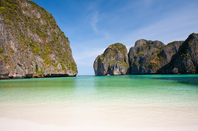
Koh Phi Phi Leh or Ko Phi Phi Ley (Thai: เกาะพีพีเล) is an island of the Phi Phi archipelago, in the Andaman Sea. It belongs to the Krabi province of Thailand.
Koh Phi Phi Leh is the second largest island of the archipelago, the largest one being Ko Phi Phi Don. The island consists of a ring of steep limestone hills surrounding a shallow bay, the Maya Bay.

Maya Bay is popular for diving, and has become even more popular after the 2000 movie The Beach was filmed there. According to the Lonely Planet's Thailand guidebook, the 2004 tsunami dramatically improved the look of Maya Bay. This was due to the fact that the high waves had cleaned up the beach and removed all the landscaping the Fox production team had added.
 Controversy arose during the making of the film The Beach due to 20th Century Fox bulldozing and rescaping of the natural beach setting of Koh Phi Phi Leh to make it more "paradise-like". The production altered some sand dunes and cleared some coconut trees and grass to widen the beach. Fox set aside a fund to reconstruct and return the beach to its natural state, however lawsuits were filed as many believed the damage to the ecosystem is permanent and restoration attempts failed.
The lawsuits dragged on for years. In 2006, Thailand's Supreme Court upheld an appeal court ruling that the filming had harmed the environment and ordered that damage assessments be made. Defendants in the case included 20th Century Fox and some Thai government officials.
 Prior to 2004, the island had avoided development. However, it is now a part of Phi Phi National Park and has since begun to see the beginnings of development and some clearing of natural plant life. There are current plans to build bungalows on the island. Since 2007, there has been an entry charge for private visitors of Bt200 per person. There are now permanent basic facilities on the island - toilets, a snack bar and camping sites.
Sources: http://en.wikipedia.org/wiki/Phi_Phi_Islands,
http://en.wikipedia.org/wiki/Ko_Phi_Phi_Don, Ko_Phi_Phi_Lee
Images: http://commons.wikimedia.org/wiki/Category:Ko_Phi_Phi