
 Doi Inthanon is part of a mountain range separating Burma from Thailand also known as Loi Lar Mountain Range or Daen Lao Range. This range, the westernmost of the Shan Highland system, separates the Salween watershed from the Mekong watershed. Other high peaks of the Loi Lar Mountain Range are Doi Luang Chiang Dao (2,175 m), Doi Pui (1,685 m), and Doi Suthep (1,601 m).
In 1954, the forests around Doi Inthanon were preserved, creating Doi Inthanon National Park, as one of the original 14 National parks of Thailand. It covers 482.40 km². The park spreads from the lowlands at 800 m altitude up to the peak in 2,565 m, thus covering many climatic and ecological different parts, thus with a total of 362 it has the second highest number of bird species of any national park in Thailand. Geologically the mountain is a granite batholith in a north-south oriented mountain range. The second-highest peak of this range is Doi Hua Mod Luang at 2,340 m.
 Doi Inthanon National Park (nickname: "the roof of Thailand") is located in Mae Chaem District, Chiang Mai Province, northern Thailand. It includes Doi Inthanon, the country's highest mountain. Established in 1972, is 482 square kilometres (186 sq mi) in size.
The park is situated approximately 60 kilometres (37 mi) from Chiang Mai. It includes Karen and Meo Hmong villages of about 4,500 people. Its elevation range between 800–2,565 metres (2,600–8,415 ft). There are a number of waterfalls such as the Mae Klang Falls, Wachirathan Falls, Siriphum Falls, and Mae Ya Falls. The park has varied climatic and ecological different sections.
Flora and fauna
Its flora includes evergreen cloud forest, sphagnum bog, and deciduous dipterocarp forest. There are some relict pines. With 383 avifauna species, it ranks second in number of bird species within Thailand's national parks.
 Its lowlands below 800 meters in elevation are warm and very dry during the rain-free season, but the summit of Doi Inthanon, at 2,565 meters, has a climate more like Canada than Thailand. The temperature has been known to drop as low as -8 degrees C. and frosts are not unusual during the cool, dry season. January is the coldest month: an average nighttime temperature is 5.5 degrees C. At any season, Doi Inthanon is a comfortable reprieve from the heat of the lowlands. At altitudes above 1000 meters, rainfall exceeds 2500 mm, considerably more than at nearby Chiang Mai. Even in the dry season, November to April, there is rare but occasional rain or the summit may be shrouded in cloud for a part of the day; persistent mist is an important factor in the maintenance of moist forest there.
  The various sub montane forest formations at higher elevations are a unique asset of the park. They have dominant species belonging to temperate climate families rather than tropical. The summit area supports the only red rhododendron in Thailand (R. delavayi); it blooms from December through February. There are also two white-blossomed species abundant on Doi Inthanon which are restricted to only a few other sites.

 Bird watching: Because of its broad altitudinal range and the cool climate of its upper reaches, the park supports the largest number of bird species of any site in Thailand. The Center for Wildlife Research at Mahidol University records a present total of 362 species and expects additions; Many at the summit are migrants from northern Asia. Species restricted to Doi Inthanon are Ashy-throated Warbler and an endemic race of the Green tailed Sunbird; the park is the only site where the Chestnut-bellied Rock thrush and the Yellow-bellied Flower pecker are known to over summer and probably breed. Over 190 bird species are listed as common to abundant. Bird lists are available at the Visitor Center and at Park Headquarters.
Places To See

Because of its easy access, this unusual waterfall has been visited by Thai people for many years and they continue to come in large numbers on any sunny day in the year to swim, picnic and relax in this beautiful setting. The rapids and waterfall spill over a wide exposure of granite and can be approached closely. Visitors are asked to exercise caution around the waterfall area and while swimming either above or below the falls. A well-maintained trail leads up the side of the waterfall, and continues to the Visitor Center and beyond.
Wachirathan Waterfall (Km 20.8)
 On the lower slope of Doi Inthanon, near the Karen hill tribe village Ban Sop Had, are the Wachirathan waterfalls (Thai: น้ำตกวชิรธาร), where the Wachirathan (lit. "Diamond Creek") tumbles over a granite escarpment. The falls are reached by a short, easy trail from the parking area. Wachirathan waters tumble down granite escarpment, creating a misty veil of great beauty. Visitors should be very cautious: three people have fallen to their deaths while taking photographs. Just a short distance on the main road beyond Wachirathan is the small Karen hill tribe village, Ban Sop Had. Turn right just past the bridge and you will find the village a few hundred meters up the dirt access road.
 Napamaytanidol Chedi (Km 41)
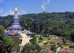
Continuing north of the main summit road, turn left at km 41.8 over a bridge on a paved road which leads to a magnificent chedi completed in 1989. These temples were built to honor the 60th birthday of the King Bhumipol and Queen in 1987 and 1992 respectively.
Summit of Doi Inthanon (Km 48)
The drive to the summit offers some fine views, especially during November and December, before the dry season haze has become well established. On your visit to the summit stupa containing the remains of King Inthawidhayanon, be sure to read the English translation on the back of the marble plaque nearby. Photographing any part of the radar station is forbidden, but visitors may take pictures freely of any other subject.


Mae Ya Waterfall (14 km from Chom Thong)
Thought to be the highest in Thailand and is well worth the extra effort to get there. Park officials estimate that the Mae Ya River plunges more than 250 meters at this point. It is a beautiful, fanning cascade, dropping down an ever-widening series of steps – without a doubt, a photographic favourite.
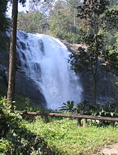
 Siriphum Waterfall
The Siriphum Waterfall (pronounced "see-ree-POOM") was an impressively tall waterfall that we noticed was accompanied by another thinner but just-as-tall companion waterfall. This was the third or uppermost of the major waterfalls on the way up to Doi Inthanon's peak (not counting the Sirithat Waterfall, which we didn't get to see), but we worked our way down from the top so it was our first waterfall stop in the park.
According the Thailand Tourism, the name of this falls came from a combination of Queen Sirikit and King Bhumipol. Thus, we also noticed some signs indicating this waterfall was referred to as Namtok Siribhum as opposed to Namtok Siriphum.
Sources, Images: http://en.wikipedia.org/wiki/Doi_Inthanon_National_Park,
http://www.chiangmai-chiangrai.com/doi_inthanon_park.html
http://www.chiangmai-chiangrai.com/doi_inthanon_park.html


0 comments:
Post a Comment