Friday, February 25, 2011

Sigiriya - Sri Lanka

Sigiriya (Lion's rock) is an ancient rock fortress and palace ruin situated in the central Matale District of Sri Lanka, surrounded by the remains of an extensive network of gardens, reservoirs, and other structures. A popular tourist destination, Sigiriya is also renowned for its ancient paintings (frescos), which are reminiscent of the Ajanta Caves of India. The Sigiriya was built during the reign of King Kassapa I (AD 477 – 495), and it is one of the seven World Heritage Sites of Sri Lanka.
Sigiriya may have been inhabited through prehistoric times. It was used as a rock-shelter mountain monastery from about the 5th century BC, with caves prepared and donated by devotees to the Buddhist Sangha. According to the chronicles as Mahavamsa the entire complex was built by King Kasyapa, and after the king's death, it was used as a Buddhist monastery until 14th century.
The Sigiri inscriptions were deciphered by the archaeologist Senarath Paranavithana in his renowned two-volume work, published by Cambridge, Sigiri Graffiti and also Story of Sigiriya.
Sigiriya is located in Matale District in the Central Province of Sri Lanka. It is within the cultural triangle, which includes five of the seven world heritage sites in Sri Lanka.
The Sigiriya rock is a hardened magma plug from an extinct and long-eroded volcano. It stands high above the surrounding plain, visible for miles in all directions. The rock rests on a steep mound that rises abruptly from the flat plain surrounding it. The rock itself rises 370 m (1,214 ft) above sea level and is sheer on all sides, in many places overhanging the base. It is elliptical in plan and has a flat top that slopes gradually along the long axis of the ellipse
History
In 477 CE, prince Kasyapa seized the throne from King Dhatusena, following a coup assisted by migara, the king’s nephew and army commander. Kasyapa, the king’s son by a non-royal consort, usurped the rightful heir, Moggallana, who fled to South India. Fearing an attack from Moggallana, Kasyapa moved the capital and his residence from the traditional capital of Anuradhapura to the more secure Sigiriya. During King Kasyapa’s reign (477 to 495), Sigiriya was developed into a complex city and fortress. Most of the elaborate constructions on the rock summit and around it, including defensive structures, palaces and gardens, date back to this period.
Kasyapa was defeated in 495 by Moggallana, who moved the capital again to Anuradhapura. Sigiriya was then turned back into a Buddhist monastery, which lasted until the thirteenth or fourteenth century. After this period, no records are found on Sigirya until the sixteenth and seventeenth centuries, when it was used as an outpost of the Kingdom of Kandy. When the kingdom ended, it was abandoned again.
Alternative stories have the primary builder of Sigiriya as King Dhatusena, with Kasyapa finishing the work in honour of his father. Still other stories have Kasyapa as a playboy king, with Sigiriya a pleasure palace. Even Kasyapa's eventual fate is mutable. In some versions he is assassinated by poison administered by a concubine. In others he cuts his own throat when isolated in his final battle. Still further interpretations have the site as the work of a Buddhist community, with no military function at all. This site may have been important in the competition between the Mahayana and Theravada Buddhist traditions in ancient Sri Lanka.
The earliest evidence of human habitation at Sigiriya was found from the Aligala rock shelter to the east of Sigiriya rock, indicating that the area was occupied nearly five thousand years ago during the mesolithic period.
Buddhist monastic settlements were established in the western and northern slopes of the boulder-strewn hills surrounding the Sigiriya rock, during the third century B.C. Several rock shelters or caves had been created during this period. These shelters were made under large boulders, with carved drip ledges around the cave mouths. Rock inscriptions are carved near the drip ledges on many of the shelters, recording the donation of the shelters to the Buddhist monastic order as residences. These have been made within the period between the third century B.C and the first century CE.
In 1831 Major Jonathan Forbes of the 78th Highlanders of the British army while returning on horseback from a trip to Pollonnuruwa came across the “bush covered summit of Sigiriya". Sigiriya came to the attention of antiquarians and, later, archaeologists. Archaeological work at Sigiriya began on a small scale in the 1890s. H.C.P Bell was the first archaeologist to conduct extensive research on Sigiriya. The Cultural Triangle Project, launched by the Government of Sri Lanka, focused its attention on Sigiriya in 1982. Archaeological work began on the entire city for the first time under this project.
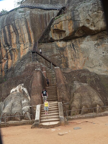
Sigiriya consists of an ancient castle built by King Kasyapa during the 5th century AD. The Sigiriya site has the remains of an upper palace sited on the flat top of the rock, a mid-level terrace that includes the Lion Gate and the mirror wall with its frescoes, the lower palace that clings to the slopes below the rock, and the moats, walls and gardens that extend for some hundreds of metres out from the base of the rock.
The site is both a palace and fortress. Despite its age, the splendour of the palace still furnishes a stunning insight into the ingenuity and creativity of its builders. The upper palace on the top of the rock includes cisterns cut into the rock that still retain water. The moats and walls that surround the lower palace are still exquisitely beautiful.
Sigiriya is considered one of the most important urban planning sites of the first millennium, and the site plan is considered very elaborate and imaginative. The plan combined concepts of symmetry and asymmetry to intentionally interlock the man-made geometrical and natural forms of the surroundings. On the west side of the rock lies a park for the royals, laid out on a symmetrical plan; the park contains water retaining structures, including sophisticated surface/subsurface hydraulic systems, some of which are working even today. The south contains a man-made reservoir, these were extensively used from previous capital of the dry zone of Sri Lanka. Five gates were placed at entrances. The more elaborate western gate is thought to be reserved for the royals.
The gardens
The Gardens of the Sigiriya city are one of the most important aspects of the site as it is among the oldest landscaped gardens in the world. The gardens are divided into three distinct but linked forms; water gardens, Cave and boulder gardens, and terraced gardens.
The water gardens can be seen in the central section of the western precinct. Three principal gardens are found here. The first garden consists of an island surrounded by water. It is connected to the main precinct using four causeways, with gateways placed at the head of each causeway. This garden is built according to an ancient garden form known as char bhag, and is one of the oldest surviving models of this forms.
The second contains two long, deep pools set on either side of the path. Two shallow, serpentine streams lead to these pools. Fountains made of circular limestone plates are placed here. Underground water conduits supply water to these fountains which are still functional, especially during the rainy season. Two large islands are located on either side of the second water garden. Summer palaces are built on the flattened surfaces of these islands. Two more islands are located further to the north and the south. These islands are built in a similar manner to the Island in the first water garden.
The third garden is situated on a higher level than the other two. It contains a large, octagonal pool with a raised podium on its northeast corner. The large brick and stone wall of the citadel is on the eastern edge of this garden.
The water gardens are built symmetrically on an east-west axis. They are connected with the outer moat on the west and the large artificial lake to the south of the Sigiriya rock. All the pools are also interlinked using an underground conduit network fed by the lake, and connected to the moats. A miniature water garden is located to the west of the first water garden, consisting several small pools and water courses. This recently discovered smaller garden appears to have been built after the Kasyapan period, possibly between the tenth and thirteenth centuries.
The boulder garden consists several large boulders linked with winding pathways. The boulder gardens extend from the northern slopes to the southern slopes of the hills at the foot of Sigiriya rock. Most of these boulders had a building or pavilion upon them. There are cuttings on these boulders that were used as footings for brick walls and beams.
The audience hall of the king was situated in the boulder garden, the remains of which are seen on the flattened and polished summit of a large boulder. There is also a five metre long granite throne in this hall. The throne is carved from the boulder itself, and is not separated from it. Another notable feature in the boulder garden is the Cistern rock, named after a large, carved cistern on top of the rock. A large archway, created by two boulders, provides access to the terraced gardens.
The terraced gardens are formed from the natural hill at the base of the Sigiriya rock. A series of terraces, each rising above the other, connect the pathways of the boulder garden to the staircases on the rock. These have been created by the construction of brick walls, and are located in a roughly concentric plan around the rock. The path through the terraced gardens is formed by a limestone staircase. From this staircase, there is a covered path on the side of the rock, leading to the uppermost terrace where the lion staircase is situated.


Source: http://en.wikipedia.org/wiki/Sigiriya
Images: http://commons.wikimedia.org/wiki/Sigiriya

Thursday, February 17, 2011

Valley of Flowers National Park - India

Valley of Flowers National Park is an Indian national park, Nestled high in West Himalaya, is renowned for its meadows of endemic alpine flowers and outstanding natural beauty. It is located in Uttarakhand state. This richly diverse area is also home to rare and endangered animals, including the Asiatic black bear, snow leopard, brown bear and blue sheep. The gentle landscape of the Valley of Flowers National Park complements the rugged mountain wilderness of Nanda Devi National Park. Together they encompass a unique transition zone between the mountain ranges of the Zanskar and Great Himalaya. The park stretches over an expanse of 87.50 km².
The Valley of Flowers is an outstandingly beautiful high-altitude Himalayan valley that has been acknowledged as such by renowned mountaineers and botanists in literature for over a century and in Hindu mythology for much longer. Its ‘gentle’ landscape, breathtakingly beautiful meadows of alpine flowers and ease of access complement the rugged, mountain wilderness for which the inner basin of Nanda Devi National Park is renowned.
Valley of flower is splashed with colour as it bloomed with hundreds different beautiful flowers, taking on various shades of colours as time progressed. Valley was declared a national park in 1982, and now it is a World Heritage Site. The locals, of course, always knew of the existence of the valley, and believed that it was inhabited by fairies.
While trekking towards valley of flowers, one can experience the beauty of shining peaks fully covered with snow. One can also see the beautiful view of surrounding greenery and various running streams with crystal clear water.
The valley is home to many celebrated flowers like the Brahmakamal, the Blue Poppy and the Cobra Lily. It is a much sought after haunt for flower-lovers, botanists and of course trekkers, for whom a sufficient excuse to embark on a mission to reach a place, is that it exists.
The Valley of Flowers is internationally important on account of its diverse alpine flora, representative of the Western Himalayan alpine shrub and meadows ecoregion. The rich diversity of species reflects the valley’s location within a transition zone between the Zaskar and Great Himalayas ranges to the north and south, respectively, and between the Eastern Himalaya and Western Himalaya flora. A number of plant species are internationally threatened, several have not been recorded from elsewhere in Uttarakhand and two have not been recorded in Nanda Devi National Park. The diversity of threatened species of medicinal plants is higher than has been recorded in other Indian Himalayan protected areas. The entire Nanda Devi Biosphere Reserve lies within the Western Himalayas Endemic Bird Area (EBA). Seven restricted-range bird species are endemic to this part of the EBA.
The Valley of Flowers was declared a national park in 1982. This part of Uttarakhand, in the upper reaches of Garhwal, is inaccessible through much of the year. The area lies on the Zanskar range of the Himalayas with the highest point in the national park being Gauri Parbat at 6,719 m above sea level.
History
According to the Ramayan this is the place where Hanuman searched for Sanjivani Booti to cure Lakshman when he was injured by Indrajit(Meghnada), the son of Ravana.
The place had disappeared from the tourist map due to its inaccessible approach but in 1931 Frank S. Smythe a British mountaineer lost his way while returning from a successful expedition to Mt.Kamet and happened upon this valley which was full of flowers. He was so attracted towards the beauty of the place he named it the "Valley of Flowers". He authored a book called "The Valley of Flowers" which unveiled the beauty and floral splendours of the valley and thus threw open the doors of this verdant jewel to nature-enthusiasts all over the world.
In 1939 Miss Margaret Legge, a botanist deputed by the Royal Botanic Gardens Edinburgh arrived at the valley for further studies. While she was traversing some rocky slopes to collect flowers, she slipped off and was lost forever. Her sister later visited the valley and erected a memorial near the spot. The memorial is still there.
Prof. Chandra Prakash Kala, a botanist deputed by the Wildlife Institute of India, carried out a remarkable research study on the floristics and conservation of the valley for a decade starting in 1993. He made an inventory of 520 alpine plants exclusively growing in this national park and authored two important books - "The Valley of Flowers - Myth and Reality" and "Ecology and Conservation of the Valley of Flowers National Park, Garhwal Himalaya'.
There is no settlement in the national park and grazing in the area has been banned. The park is open only in summer between June and October, being covered by heavy snow during the rest of the year.
The Trek
Getting to the Valley of Flowers requires a trek of about 17 km. The nearest major town is Joshimath in Garhwal, which has convenient road connections from Haridwar and Dehradun, both about 270 km from Joshimath.
Govindghat is a small place close to Joshimath (around one hour distance), from where the trek starts.From Gobindghat, a trek of 14 km brings trekkers to the Ghangaria, a small settlement located about 3 km from the valley. The valley starts near a gorge over the Pushpawati River.
Fauna & Flora
The park is home to tahr, snow leopard, musk deer, red fox, common langur, bharal, serow, Himalayan black bear, Himalayan brown bear, Pika (Mouse hare) and a huge variety of butterflies. Among the important birds and Pheasant are, Himalayan Golden Eagle, Griffon Vulture, Snow Partridge, Himalayan Snowcock, Himalayan Monal, Snow Pigeon, Sparrow Hawk etc.
Flowers mostly orchids, poppies, primulas, marigold, daisies and anemones carpet the ground. Alpine forests of birch and rhododendron cover parts of the park's area. A decade long study of Prof. C.P. Kala from 1993 onwards concludes that the Valley of Flowers endows with 520 species of higher plants (angiosperms, gymnosperms and pteridophytes), of these 498 are flowering plants. The park has many species of medicinal plants including Dactylorhiza hatagirea, Picrorhiza kurrooa, Aconitum violaceum, Polygonatum multiflorum, Fritillaria roylei and Podophyllum hexandrum.
Other Attractions
Hemkund Sahib: A very popular trekking destination, Hemkund is a 19 km trek from Govindghat. The high altitude lake known as Hemkund (4,329 m) is located here. The lake and its picturesque surroundings are an important pilgrim center for both Hindus and Sikhs. Close to the lake, the sacred Sikh Gurudwara and a Lakshman temple are located.
Joshimath: One of the popular pilgrim centres in Uttrakhand, Joshimath was established by Adi Shankaracharya in the 8th century. There are the temples of Nav Durga and Narsingh here. This scenic town is also the base for trekking to the Valley of Flowers.
Badrinath: Badrinath, one of the holy places for Hindus in India. It is the most sacred Dham in India. Badrinath is located in the Chamoli district of Uttranchal, at around 3,133 m high from the sea level. Badrinath temple is dedicated to Hindu god Vishnu. This temple is near to the Alaknanda River.
How to reach: The nearest airport is in Jolly Grant, Dehradun, 295 kilometers (183 miles) away, and the nearest railway station is in Rishikesh, 276 kilometers (170 miles) away. The closest you can get to The Valley of Flowers by road is Govind Ghat. This requires around a 10 hours drive to Joshimath, then another one hour to Gobindghat. From Gobindghat it is a 13-kilometers (8 miles) trek along a steep, narrow, but well defined mountain trail to base camp at Ghangaria. This will take between 4 and 8 hours, depending on your fitness. Ghangaria has Hotels with Electricity and Mobile towers. From Ghangaria Another 3 km Trek Leads to Valley.

 
Source: http://en.wikipedia.org/wiki/Nanda_Devi_and_Valley_of_Flowers_National_Parks
Images: http://commons.wikimedia.org/wiki/Category:Valley_of_Flowers_National_Park

Friday, February 4, 2011

Ayutthaya Historical Park - Ayutthaya

The Ayutthaya historical park (Thai: อุทยานประวัติศาสตร์พระนครศรีอยุธยา) covers the ruins of the old city of Ayutthaya, Thailand, which was founded by King Ramathibodi I in 1350 and was the capital of the country until its destruction by the Burmese army in 1767. Ayutthaya Historical Park is the most important tourist site for Thailand tourism outside Bangkok in Central Thailand. Ayutthaya is a one hour drive north from Bangkok.
In 1969 the Fine Arts Department began with renovations of the ruins, which became more serious after it was declared a historical park in 1976. The park was declared a UNESCO World heritage site in 1991. According to "Tourism Asia", thirty-three monarchs including King Rama IV governed from Ayutthaya.
Ayutthaya is important as it was the center of the Ayutthaya Kingdom for 417 years, the creative center for the Ayutthaya style of art, the defining kingdom in Southeast Asia and the start for the subsequent Bangkok Empire which was later founded by the survivors of the Burmese sacking.
To understand Ayutthaya one needs to understand the belief systems, the role of personalities including foreigners, the role of rivers and the canal system, the role of elephants and guns in warfare, the places of cultural heritage, the strengths and weaknesses of Kings and other royal and noble members in Siam society and the role of foreign communities from Japan, the muslim world, Portugal, France, Holland and Britain. Well informed with a sense of history, events and people a trip to Ayutthaya is well worth while.
When taking tours be careful to insist on giving enough time to see these important sites and not be diverted with time wasting diversions. To see everything requires several days. If you seek to see it all in one day a private tour or taxi is needed with an early start. Ayutthaya was an international trading center in Southeast Asia and a visit to the ruins, temples and monuments today will be greatly enhanced by prior reading about the characters who shaped Ayutthaya, their belief systems and fate in history.
This is a very exotic period in Thai history when Kings and their subjects believed Kings were gods, when the Catholic Church from France sought to change Siamese Buddhist minds, when Portuguese traders controlled trade and Portuguese mercenaries influenced war selling their modern methods of warfare and when Asian feudal Kings played war between themselves and with other lives as a game of egos and adventure.
Today, this historic city is a home to numerous magnificent structures and ruins concentrated in and around the city island surrounded by Chao Phraya River, Pa Sak River and Lopburi River. Ayutthaya historical park sites include;
  • Wat Mahathat
  • Wat Phra Sri Sanphet
  • Wat Chaiwatthanaram
  • Wat Ratchaburana
  • Wat Phra Ram
  • Viharn Phra Mongkhon Bophit
  • Wat Lokayasutharam
  • Wat Yai Chai Mongkhon
  • Wat Phanan Choeng
  • Wat Phu Khao Thong
  • Phra Chedi Suriyothai
  • Ayutthaya historical Study Centre
  • Japanese Settlement
  • Elephant Camp
Japanese village (Thai: หมู่บ้านญี่ปุ่น): Memorial Site of the Old Japanese Settlement in Ayutthaya.
Ayutthaya was the capital of the Kingdom of Thailand for 417 years from B.E.1893 (A.D.1350) to B.E.2310 (A.D.1767). During this period, in the second half of the 16th Century, foreigners began to come to the Kingdom and gradually in number. These foreigners were traders, missionaries, and some were engaged as volunteer guards of the King. Japanese trade aboard was also boosted when the Japanese Authorities granted official permission to travel for trading purposes by issuing the "Shuin" (Red Seal). Along with the official ships bearing the seal, unauthorized ships also sailed to South East Asia with many Japanese. Among the travelers were those who came to Ayutthaya. The King granted permission to the Japanese, as well as other nationalities, to settle. At that time there were 800 to 3,000 Japanese reported to be living in Ayutthaya.
There's nothing left of the Japanese Settlement, so instead, the Japanese government decided to create a Japanese-style park at the location of where the Japanese Settlement probably must have been. The Ayutthaya Historical Study Center started a branch here, a museum about Ayutthaya's foreign relations with Japan and other countries. It starts with an interesting movie of about 15 minutes and then you can explore the museum on your own. It's about all the trading nations that visited this city. Very interesting and definitely gives a good background of the city's history.
Ayutthaya Elephant Camp provides elephant ride attractions. Visitors can ride the friendly and noble animal and traverse the same roads where former kings once walked. The Camp is dedicated to the preservation and welfare of domestic elephants which are paramount to Thailand’s history spanning over 5000 years. The Royal Elephant Kraal has been restored which was once a prime elephant hub from early 1350 to 1900s.
It is home to over hundred elephants where they receive utmost care with a help of expertly designed health system. The Camp encourages tourists for an ‘up close and personal’ experience with Elephants. This includes tons of information and plenty of riding over the course of the stay. A 3-hour trek includes an adventurous tour within the historic Ayutthaya city and lessons on giving instruction to your elephant.
They are provided with a chance to be a ‘mahout’ and get to know a single elephant. Visitors can either rent a tent or experience an authentic Thai style, living side-by-side with elephants or else can opt for a modern style of living. They can even choose to bathe the elephant in the Lobpuri River.
Elephant Kraal Pavilion (Paniat, Thai: พะเนียด). In the old time wild elephants were searched and chased into the "paniat". This Pavilion was utilized as the royal seat to witness the elephant round up. It is located 4 km. northeast of the town along Highway No. 309. The outlook is a big cage surrounded with logs having, from the front centre, fencing lines of 45 degrees spread out to both sides far away into the jungle area.
Ayutthaya Historical Study Center, Rojana Rd (Rotchana Rd). Interesting museum about the history of Ayutthaya. It's best to visit this museum before heading out elsewhere, as it places the remains into a historical perspective. A big part of the museum is dedicated to Siam's relations with other peoples, but village life, art and culture are also dealt with.
Chao Sam Phraya National Museum. Most treasures of Ayutthaya were stolen, burnt and melted by armies or treasure hunters. Some pieces survived though and are exhibited at this museum. Most of the riches are golden statues found at Wat Ratchaburana and Wat Mahathat.


Sources: http://en.wikipedia.org/wiki/Ayutthaya_Historical_Park, 
http://www.bangkoksite.com/AyutthayaPage
Images: http://commons.wikimedia.org/wiki/Category:Ayutthaya_historical_park

Wat Chaiwatthanaram - Ayutthaya

Wat Chaiwatthanaram (Thai: วัดไชยวัฒนาราม) is a Buddhist temple in the city of Ayutthaya, Thailand, on the west bank of the Chao Phraya River, outside Ayutthaya island. It is one of Ayutthaya's most well known temples and a major tourist attraction.
Wat Chaiwatthanaram lies on the west bank of Chao Phraya River, south west of the old city of Ayutthaya. It is a large compound and is a UNESCO World Heritage Site. It can be reached by road or by boat.
History
The temple was constructed in 1630 by the king Prasat Thong as the first temple of his reign, as a memorial of his mother's resident in that area. The temple's name literally means the Temple of long reign and glorious era. It was designed in Khmer style which was popular in that time. It has a central 35 meter high prang in Khmer style (Thai: พระปรางค์ประธาน) with four smaller prangs. The whole construction stands on a rectangular platform. About halfway up there are hidden entrances, to which steep stairs lead.
The central platform is surrounded by eight chedi-shaped chapels (Thai: เมรุทิศ เมรุราย - Meru Thit Meru Rai), which are connected by a rectangular cross-shaped passage (Phra Rabieng). The passage had numerous side entries and was originally roofed and open inwards, but today only the foundations of the pillars and the outside wall still stand. Along the wall, there were 120 sitting Buddha statues, probably painted in black and gold.
The eight chedi-like chapels are formed in a unique way. They had paintings on the interior walls, the exterior ones decorated by 12 reliefs depicting scenes from the life of Buddha (Jataka), which must be "read" clockwise. Just fragments of the paintings and the reliefs survived. In each of the rectangular chedis were two sitting Buddha statues and in each of the four middle chedis was one big sitting Buddha statue, also lacquered in black and gold. The ceiling over those statues was of wood with golden stars on black lacquer.
Outside of the passages on the east, close to the river was the temple's ordination hall (Phra Ubosot). North and south from the Ubusot stood two chedis with "12 indented corners", in which the ashes of the king's mother were laid. After the total destruction of the old capital (Thai: กรุงเก่า - Krung Kao) by the Burmese in 1767, from which Wat Chai Watthanaram was not spared, the temple was deserted. Theft, sale of bricks from the ruins and the beheading of the Buddha statues were common. Only in 1987 did the Thai Department of Fine Arts start restoring the site. In 1992 it was opened to the public.
Wat Chaiwatthanaram was a royal temple where the king and his successors performed religious ceremonies. Princes and princess were cremated here, including King Boromakot's son Chaofa Thammathibet (เจ้าฟ้าธรรมาธิเบศร).
The Wat Chaiwatthanaram structure reflects the Buddhist world view, as it is described already in the Traiphum Phra Ruang, the "three worlds of the King Ruang", of the 14th century: The big "Prang Prathan" that stands in the centre symbolizes the mountain Meru (Thai: เขาพระสุเมรุ - Khao Phra Sumen), which consists the central axis of the traditional world (Kamaphum - กามภูมิ). Around it lie the four continents (the four small Prangs) that swim in the four directions in the world sea (นทีสีทันดร). On one of the continents, the Chomphutawip (ชมพูทวีป), the humans live. The rectangular passage is the outer border of the world, the "Iron Mountains" (กำแพงจักรวาล).


The ancient city of Ayutthaya, or Phra Nakhon Si Ayutthaya, The Thai capital for 417 years, is one of Thailand's major tourist attractions. Many ancient ruins and art works can be seen in a city that was founded in 1350 by King U-Thong when the Thais were forced southwards by northern neighbours. During the period of Ayutthaya being the Thai capital, 33 Kings of different dynasties ruled the kingdom until it was sacked by the Burmese in 1767.


Source: http://en.wikipedia.org/wiki/Wat_Chaiwatthanaram
Images: http://commons.wikimedia.org/wiki/Category:Wat_Chaiwatthanaram

Thursday, February 3, 2011

Wat Phra Sri Sanphet - Ayutthaya

Wat Phra Sri Sanphet (Thai: วัดพระศรีสรรเพชญ์) is situated on the City Island in Ayutthaya’s World Heritage Park in Pratuchai sub-district. It has been registered as a national historic site by the Fine Arts Department since 5 March 1935. This monastery was the most important temple of Ayutthaya and situated within the Royal Palace grounds. It served as a model for the Temple of the Emerald Buddha in Bangkok.
In 1350, Prince U-Thong ordered a palace built in an area called Nong Sano, actual the area in the vicinity of Bueng Phra Ram. The palace contained three wooden buildings named "Phaithun Maha Prasat", "Phaichayon Maha Prasat", and "Aisawan Maha Prasat". Upon finalization of the palace in 1351, he established Ayutthaya as his capital and was bestowed the title of King Ramathibodi I. The original size of the old palace compound is believed to be the same as the area of Wat Phra Sri Sanphet today.
Wat Phra Sri Sanphet, being part of the royal palace, was exclusively used by the Ayutthayan Kings. No clergy was allowed to reside on the grounds, with exception of an occasionally invitation to pray and to perform ceremonies such as the taking of an oath of allegiance for royal officers and for preaching and merit-making by the King. The expansion of the temple caused the moving of the Buddhist center from Wat Mahathat to Wat Phra Sri Sanphet.
In 1499, a principal viharn was built. The following year, in 1500 A.D. King Ramathibodi II commanded the casting of a standing Buddha image 16 meters high and covered with gold. This image, Phra Buddha Chao Sri Sanphet was the main object of veneration in the royal viharn (hall of worship). After that time the ashes of members of the royal family other than the kings were placed in small chedis constructed at the site.
The temple enshrined also the Phra Buddha Lokanat (Protector of the World) and the Phra Buddha Palelai. The third chedi was built by King Boromracha IV (r. 1529-1533) to house the remains of King Ramathibodi II. The Greek cross-shaped viharn at the west side of the temple was added during the reign of King Narai. It is not clear if the square mondop structures adjacent to the chedi were built around this time or later. On the eve of the Burmese invasion, the central portion of the temple included three gilded chedis, three gilded mondops (square buildings adjacent to the chedis that held objects of worship), and two very large viharns.
When Ayutthaya fell in April 1767, the Burmese sacked and burned the monastery to the ground. All but the chedis were completely destroyed. Buddha images were taken away and from the larger ones, the gold was melted. The Buddha image Phra Palelai in the southern chapel was completely destroyed.
The monastic structures in Wat Phra Sri Sanphet were basically straight aligned on an east-west axis. The main entity was formed by the prasat, the three chedis with their mandapas, and the Royal vihara or chapel presiding over all structures.
The three chedis, being the core of the temple, rested on a high platform with the later built mandapas (square structures with a spire) situated at the eastern side of each chedi. The elevated platform was surrounded by a walled gallery, running from the Westside of the Royal chapel towards the eastern portico of the prasat, a cruciform structure.
During his reign King Rama I (1782 -1809 A.D.) of the Ratanakosin Period ordered the transfer of the inner core of Phra Buddha Chao Sri Sanphet from Ayutthaya to Wat Phra Chetuphon in Bangkok, and had it placed in a chedi specially built for the purpose. Another Buddha image of importance called Phra Buddha Lokanat was also brought to this wat at about the same time.

Source: http://www.ayutthaya-history.com
Images: http://commons.wikimedia.org/wiki/Category:Wat_Phra_Si_Sanphet

Wednesday, February 2, 2011

Wat Mahathat - Ayutthaya

Wat Mahathat (Thai: วัดมหาธาตุ) or the “Monastery of the Great Relic” is located on the City Island in the central area of Ayutthaya at Tambon Tha Wasukri. The temple is situated on the corner of the present Chikun Road and Naresuan Road. The monastery stood on the west bank of Khlong Pratu Khao Pluak, an important canal, which has been filled up somewhere in the early 20th century. In ancient times the temple was likely fully surrounded by canals and moats. The structure has been registered as a national historic site by the Fine Arts Department on 8 March 1935 and is part of the Ayutthaya World Heritage Historical Park.
Wat Mahathat was one of the most important monasteries of the Ayutthaya kingdom, not only because it was the religious centre and enshrined relics of the Buddha, but also because of its proximity to the Grand Palace. It was a royal monastery and the seat of the Supreme Patriarch of the City Dwelling sect till the end of the Ayutthaya period - at par with the Supreme Patriarch of the Forest Dwelling sect, which had its seat at Wat Yai Chai Mongkhon (called Wat Pa Kaew in earlier times).
Wat Mahathat was restored again in King Borommakot’s reign (r. 1733-1758). Four porticos were added to the prang, which was restored at the same time as the royal vihara and the ordination hall. No evidence of restoration of the monastery could be found after. Obviously chedis, prangs, and viharns were added on several occasions in time. At the fall of Ayutthaya in 1767, the monastery was set on fire in the Burmese attack.
Wat Mahathat housed before an unusual Buddha image of green stone believed to be made in the Dvaravati style (Mon) dating from 707 - 757 AD. A governor of Ayutthaya got this statue moved to Wat Na Phra Men during the reign of King Rama III, where it still resides in a small viharn next to the ubosot. The main prang of Wat Mahathat survived until the reign of King Rama V. On 25 May, 1904, the main prang collapsed at the level of the niche. The prang fell further apart in 1911 during the reign of King Rama VI. The Fine Arts Department restored it partially. The symmetrical base with staircases on the four sides is all what remains of the once majestic prang.
Wat Mahathat was certainly not exempted from looting. From its destruction in 1767 until its restoration by the FAD last century, the temple has been prone of severe looting and damage by illegal excavation. Wat Mahathat as Wat Phra Ram, Wat Phutthaisawan and the later built Wat Rachaburana follows the Khmer concept of temple construction. We find nearly identical, but earlier built structures at Angkor. Phnom Bakheng, Preah Rup, East Mebon, Baphuon and Ta Keo were all Temple Mountains, consisting of a central tower surrounded by four corner towers, forming a quincunx, the latter also often was surrounded by a courtyard and a gallery.
All temples in the early period of the establishment of Ayutthaya were clearly Khmer styled, consisting primary of laterite structures (instead of sandstone) and bricks, enhanced with stucco. Wat Mahathat consisted basically of a large central prang surrounded by four subsidiary prangs at the four inter-cardinal points, standing on a raised square platform. The quincunx was surrounded by a courtyard and a roofed gallery, lined with a row of Buddha images. Typically for the Ayutthaya period is that often the gallery was penetrated by a monastic structure, being an ordination or an assembly hall, or even sometimes both. An exception to this was Wat Phutthaisawan.
The principal prang of Wat Mahathat was constructed of laterite at the base. The top part of the stupa was of brick and mortar. Brick work at the four sides of the base indicates that the prang had porches in the cardinal directions, a feature not used in the Early Ayutthaya period (1351 - 1491). These porches could be reached by a staircase. Historians believe that these porches were added during the renovation of the temple done in 1633 during King Prasat Thong’s reign. Mural paintings of Buddhas in the different postures were found inside the prang. The prang stood until the beginning of the 20th century, but finally the brick part collapsed as unfortunately no preserving had been done since the fall of the city in 1767. Fifty years after its collapse a crypt was found containing relics of the Buddha inside the stupa.
The Viharn Luang or the Royal Assembly Hall of Wat Mahathat stood east of the prang, orientated towards Khlong Pratu Khao Pluak. The rectangular structure was quite large, measuring 40 m by 20 m. The vihara had a front porch (east) which could be reached by tree staircases. There was also an entry into the hall from both sides. Behind the main pedestal were two exits leading down to the gallery. The multi-tiered roof of the viharn was supported by two rows of columns. The hall contained mural paintings of the Vessantara Jataka. Viharn Luang has undergone several restorations in the past as well as in recent times.
During the reign of King Rama VI in the Rattanakosin period, about 1911 A.D., the main prang of the wat collapsed again and looters seized the opportunity to dig for treasure. Only in 1956 A.D. did the Fine Arts Department undertake excavations around the central area of the prang where the relics must have been kept. The relics of the Buddha were found in the stupa within a seven layer reliquary. Other antiquities were recovered as well, including Buddha images, votive tables, covered boxes shaped like fish and golden plaques in the form of animals. All these objects are now at the Chao Sam Phraya National Museum.


Source: http://www.ayutthaya-history.com
Images: http://commons.wikimedia.org/wiki/Category:Wat_Mahathat_(Ayutthaya)

Followers